 In the heart of Portage County in central Wisconsin, the City of Stevens Point sits in the cradle of two magnificent rivers – the Wisconsin and the Plover. Indeed, at darling Iverson Park the moniker “City of Wonderful Water” is literally spelled out in rocks. Together with the surrounding landscape of conifers, these central waters gave birth to the city a century and a half ago by way of sawmills and pineries. Today, they inspire paddlers to find refuge and escape, pining for an urban oasis. Fortunately, two other streams – Mill Creek and the Tomorrow-Waupaca River, west and east of Stevens Point, respectively – double the paddling opportunities with which the county is endowed. Added to those are a dozen ponds and lakes, not to mention the huge flowage created by the hydroelectric dam on the Wisconsin River in Stevens Point, water-enthusiasts could spend a couple weeks up here and never paddle the same segment twice.
![]()
RIVER AND CREEK PADDLING
Mill Creek
Mill Creek begins in Wood County’s biggest city, Marshfield, well northwest of where it empties into the Wisconsin River near the Biron Flowage section between Wisconsin Rapids and Plover. For most of its journey the quaint creek simply isn’t navigable on account of its impractically narrow streambed and prone nature to fallen trees. Paddlers should find a little more forgiveness at County Highway C. More wooded than agricultural, this section of the creek shines with an “up north” glimmer. The whole nature of Mill Creek changes dramatically a couple miles past Robin Lane, where it tumbles through granite bedrock and big boulders left behind from the glaciers in engaging Class I-II rapids conditions while surrounded by a stunning setting. To wit, at County Highway PP is a near-mile of Class I rapids that is pure joy – when the water is high enough to paddle. It’ll quiet again shortly after Highway 66 (although not without one last splash), and then the current will all but disappear in the 100-acres-large backwaters of its blurry confluence at the Wisconsin River. In autumn, the crisp colors and back-lit shadows from a low sun create a kaleidoscopic effect that’s positively mesmerizing!
Robin Lane to West River Drive
Miles: 4 | 2016 Trip Report
A short trip in order to get the most whitewater bang for your paddling buck, this segment of intimate Mill Creek will reward experienced kayakers and canoeists with Class I-II rapids through boulder gardens, ledges, and stunning rock outcrops. These final four miles of the Mill Creek are not suitable for everybody and should be considered only by paddlers with the skill and gear to handle whitewater conditions. Furthermore, this trip can only be paddled when there’s sufficient water volume, typically after an inch or more of rain or snowmelt in spring.
As a bonus, the take-out here is adjacent to aptly named Randy’s Backwater Saloon, which truly is a hoot and a holler in and of itself, and has fabulous (and fabled) Bloody Mary’s to boot.

River Level Recommendations:
There is no online gauge for Mill Creek. However, there is a spray-painted gauge at the bridge pylon of County Highway PP (upstream side of the bridge, on river-left). Look for a level around 2′ for “Goldilocks” conditions that are neither too shallow nor too high. The creek is runnable at 1′, but you’ll do a lot of scraping and probably walk your boat in some sections. Above 3′, the creek becomes incredibly rowdy and suitable only for experienced whitewater paddlers.
Camp:
Jordan Park
Lake Emily Park
Food:
Rusty’s Backwater Saloon
Rent:
Divepoint Scuba Paddle
Map:
![]()
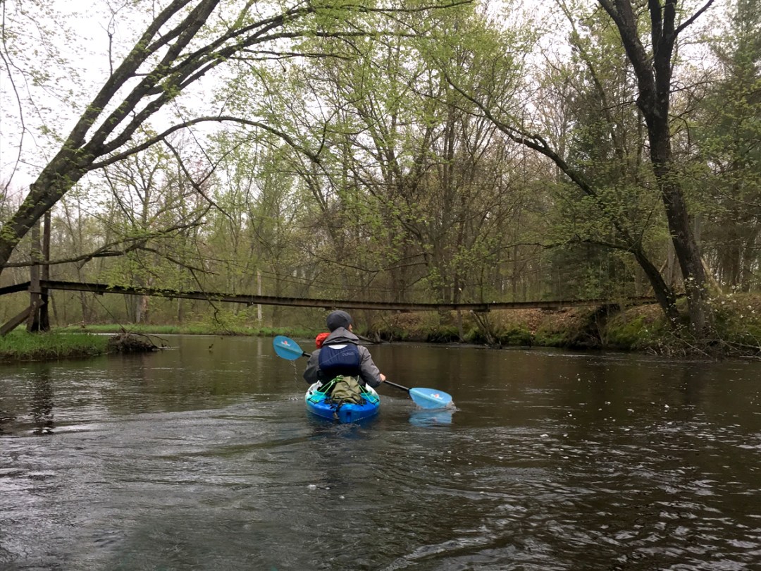
Plover River
The Plover is one of those rivers that tends to get overlooked and lost in the shadow of other adjacent streams, much to the delight of locals (but misfortune of devoted paddlers who don’t live in the area). Why this is so, we’re not sure. It’s narrow and meandering, engaging and intimate. It’s endowed with wildlife and has a mostly undeveloped landscape. It’s lined by pine trees and blessed with crystal clear water with a sand-gravel bottom. It’s got good current and generally reliable water levels. Oh, and did we mention it’s got boulder gardens galore and lots of luscious riffles? What’s there not to love about the Plover?
Originating in southwestern Langlade County in between Antigo and Aniwa, the Plover River’s first 15 miles trickle along a public fishing corridor. From the hamlet of Hatley in Marathon County to the city of Stevens Point in Portage County there are some 40 miles of paddleable conditions, although catching the river with enough water to avoid significant scraping and/or walking your boat will be tricky in its upstream segments. Conversely, on account of its many boulder gardens, downed tree hazards, and low-clearance private bridges, paddlers are advised to stay off the upstream segments of the Plover when it’s running high.
With the Wisconsin River coming from the northwest and the Plover River from the northeast, together with the geographic area surrounded by towering pines, Stevens Point was founded in the delta of these two streams and quickly took to harnessing their power for sawmills and floating down logs. Indeed, Point was known as the “Gateway to the Pines.” Today, there are four dams slowing down the Plover – not to mention the concrete-rubble remains of a former one – all used for agriculture or hydropower; the Plover’s pinery days are a thing of the past captured in historical museums, kiosks, and plaques. Geologically, the river bisects two dominant glacial characters: boulders and gravel in its upstream sections, and outwash sand downstream.
In Portage County, paddlers have their choice of two distinctly different river trips on the Plover – basically, above or below Highway 66 – each making for delightful excursions. The best section of the Plover north of Highway 66 begins at Bentley Road and concludes at Jordan Park (where paddlers have to take out, on account of the dam). That’s an 8.5-mile trip, although it can be shortened by beginning at County Highway K instead for a 5.3-mile trip. South of Highway 66 is the classic Jordan County Park to Iverson Park section, a favorite of locals that’s just under 8 miles. Below Iverson Park (an absolute gem of a city park, by the way), the river backs up to a slow flowage called McDill Pond, created by yet another dam. While the “pond” is predominated by development along its shores, there are some salient features that would attract paddlers, such as the Erickson Audubon Wildlife Area, sporadic osprey and cliff swallow nests, the Green Circle Trail, and Spring Slough.
Shantytown Road to Jordan County Park
Miles: 14.25 | 2019 Trip Report
The 5.5 miles from Shantytown Road to Bentley Road can be skipped so that paddlers get only the best of the wild-feeling woods, abundant wildlife, gorgeous water clarity, spooky floodplains, a fun rapids ledge, and a boisterous boulder garden leading to Jordan Pond. Paddlers would do well to begin this stretch of the Plover either at Bentley Road or County Highway K. Water levels are generally reliable for this trip. We strongly advise scouting the rapids and ledge at the former dam site along County Highway Y (along the shuttle) to determine if the drop has enough water to run, which line is the best to run the ledge at, and whether you feel comfortable running it in the first place. If in doubt, don’t overthink it; just portage around it. Also, if the wind is from the south, you may wish to skip paddling across Jordan Pond altogether, as it will be a bit of a slog. But this is a magnificent little trip that offers a lot of diversity and will inspire paddlers to come back for more.
Note: There is a lot more Plover River upstream of Shantytown Road – including some of its most scenic segments – but those all fall within the whereabouts of Marathon County, not Portage County.
Jordan County Park to Iverson Park
Miles: 7.75 | 2019, 2013 Trip Reports
This popular trip (and the last section of moving water) begins and ends at quaint public parks. Along those two points paddlers will encounter virtually no signs of civilization until the end of the trip, instead being treated to a dazzling juxtaposition of pine trees, steep sand banks, and swampy bottomlands. An obstacle course of downed trees to maneuver around, under, or over in a steady current will pose the only hazards, making this trip more suitable for experienced paddlers. Check water levels with local outfitters to make sure the river isn’t too high, which could pose problems with the tree obstructions. In springtime the banks are awash in a lush green of adorable (and edible) fiddlehead ferns. The fall foliage is nothing to shake a stick at either!

River Level Recommendations:
USGS Gauge: 130-350 cfs.
Water levels are usually reliable for these trips.
Camp:
Collins Park
Jordan Park
Food:
Hilltop Pub & Grill
McZ’s Brew Pub
Kozy Yak Brewery & Winery
Rent:
Divepoint Scuba Paddle
Nature Treks
Map:
![]()
Tomorrow-Waupaca River
As quintessential a stream as the central waters of Wisconsin get, the Tomorrow-Waupaca abounds with crystal-clear water and a sand-gravel bottom, reputable current (but rarely pushy), some boulder gardens, modest hillsides flanked by pines, and numerous accesses to tailor individual length trips together with long public fishing corridor easements. Approximately 60 miles long, the river quietly begins near Rosholt in Portage County with all the look and feel of a tiny creek – indeed, quite likely the narrowest stream we’ve ever paddled anywhere! – but eventually empties into the Wolf River much wider and slower than its origins.While there is one dam to portage around, in Amherst, there is a beautifully restored mill shortly before it to offset the minor inconvenience. Similarly, in spite of the surround sound noise for a few miles in one section, as well as a couple of barbed and electrical wires to be mindful of, the scenery is still quite beautiful and the paddling environment optimally engaging.
To clear up some ambiguity, the Tomorrow and Waupaca Rivers are one and the same stream. Where it is called one and not the other seems intriguingly a hotbed of colloquial confusion and perhaps the stuff of fisticuffs. Furthermore – and stay with us here – waupaca is a Native American word meaning “tomorrow.” Why the same river goes by two names that each mean the same thing is anybody’s guess. But the story behind its name is interesting – apparently it was called “waupaca” because it took a day to paddle it, meaning one would arrive to the desired destination “tomorrow.” For the sake of consistency and, well, common sense, the difference should be split at the county line, such that it were the Tomorrow River in Portage County and the Waupaca River in Waupaca County. (But if logic and common sense prevailed, Isle Royale would be a part of Minnesota, and the whole U.P. would still belong to Wisconsin, but those are separate contentions entirely.) So, out of deference to other guides and maps, as well as differing attitudes, we’ll simply refer to the river as the Tomorrow-Waupaca. (But wouldn’t “Tomorrapaca” be a lovely name)?
The most popular starting point to begin a trip on the Tomorrow-Waupaca is along the banks of the beautiful Rising Star mill in Nelsonville, where art exhibits and bluegrass concerts are held. But from here to the dam in Amherst makes for a 4.4-mile trip (a mile of which is the impounded flatwater pond behind the dam, which in summertime is choked with weeds and makes for an unpleasant slog). Paddlers have two options for beginning upstream to make a longer outing on the water: at Highway 161 (aka Loberg Road) or County Highway Q (aka Rolling Hills Road). Furthermore, the pond can be skipped by taking out at Cate Park. In our opinion, this is the best section of the river upstream of the Amherst dam – from County Q to Cate Park, for a 5.5-mile trip that showcases its best features with the fewest nuisances. It makes for a delightful time outdoors that’s neither too short nor too taxing.
The first couple miles below the dam in Amherst are mixed. On the one hand, there are some beautiful big boulders right away, a couple pleasant riffles up to and including a fun splashy Class I rapids drop, and a stately century-old railroad bridge. On the other hand, there are trees to dodge and low-clearance bridges to duck under, plus the white noise roar of cars and trucks whirring by at 70+ mph on Highway 10 is inescapable for the first 4.5 miles, which is an unwelcome distraction. For the record, you’ll paddle under Highway 10 a total of three times. Paddlers can skip the brunt of the bridge-din by putting in along Bucholz Road immediately upstream of the last Highway 10 interval. (There’s no dedicated landing along Bucholz Road – or universal consensus on how the road is spelled – but the banks here are relatively flat, making access to the water pretty easy.) The advantage of doing this is of course skipping the mosquito-like annoyance of the whining whir of the highway. The one notable disadvantage is forfeiting a lively Class I drop underneath Kenner Road, two miles downstream from the Amherst dam.
Once the last Highway 10 bridge is behind you, the best of the Tomorrow-Waupaca’s awaits, beginning with a beautiful boulder garden. There’s something about this part of the state that’s geologically distinct in its post-glacial endowments. Whereas other sections of Wisconsin might be marshy and relatively flat, the result of an incalculable mass of an ice mountain melting – to wit, just southeast and southwest of Portage County (Hello, Weyauwega! Nice to see ya, Necedah!) – here the defining characteristics of the glaciers are twofold: sand-gravel bottoms to the regional rivers and LOTS of big-shouldered boulders. There’s a Portage County Park nearby called Standing Rocks. It’s a great place for XC skiing (or hiking the rest of the year), and back in the day the motto at the park was “home of the glacial erratic and the skiing fanatic.” An erraticis simply a boulder deposited from a receding glacier, and the Tomorrow-Waupaca River has got oodles of them!
The river has a whole lot of gentle hills as well. Nothing terribly tall or dramatic – no cliffs or bluffs – but no less lovely either. Think of them as attractive little ridges with a mix of deciduous and conifers, making for an extraordinarily eye-catching palette of colors in fall’s foliage. Another thing the river has got a lot of? Riffles and light Class I rapids. The current chugs along at a reputable clip most of the time – which is why checking water levels beforehand is imperative, as there most definitely is a thing as “too shallow.” (Conversely, too high will prove to be challenging, considering the downed trees.) The most notable run of light whitewater is at County Highway DD, on the upstream and downstream sides of the bridge, where there are boulders to dodge, rock walls to avoid, and ledges to line up. It’s a lively stretch! (Unfortunately, it has a wire strung across the water also to be aware/careful of. Speaking of which, there’s one earlier, too, on the upstream side of County Highway T. Again, high water makes these particularly dangerous – especially in a canoe.) If nothing else, make an excursion to Stedman County Park here along the banks of the river to take in the wild scene (and to scout for any obstructions before running this stretch). Watch for hobits, too; the park has the look and feel of somewhere from Middle Earth.
The final miles of the Tomorrow-Waupaca in Portage County are easy and lovely, with no rapids or wires to speak of, just one fun little drop beneath the Cobbtown Road bridge, which doubles as a fine take-out location. There will still be trees to be mindful of in between County DD and Cobbtown, but it’s generally peaceful and pastoral.
All in all, the Tomorrow-Waupaca is simply a must-do experience for paddlers of all backgrounds! While you’re at it, why not make a weekend of it? Lake Emily County Park has delightful campsites along with scores of opportunities for swimming, fishing, and general fooling around the lake. Near the southeast end of the lake and park you can hop onto the Tomorrow River State Trail and bike to downtown Amherst where there are several good restaurants. But perhaps the heart’s darling of Amherst is Central Waters Brewing Company, hands down one of the best breweries in all of Wisconsin and where the art of bourbon barrel aging has been honed in, second to none. Or if it’s too early for a cold one, there’s an awesome and adorable java joint, Ruby Coffee Roasters, located just across the road from the mill in Nelsonville.
Rolling Hills Road to Amherst
Miles: 6.5 | 2014 Trip Report
An endearingly narrow, intimate stream with crystal clear water, nice current, a couple of boulders to dodge and a sense of quiet solitude, the Tomorrow is a fun little trip tucked away in the gentle hills of central Wisconsin. On the downside, the river is so narrow here that it’s prone to deadfall. And then there’s the classic conundrum of a stream itself that could benefit from a higher water level due to its often shallow conditions tempered by low-clearance bridges and culverts that have to be portaged if the water level is too high. In addition, there’s a long slog of flatwater created by the dam in Amherst that, in summertime especially, is choked with weeds. But this can be mostly avoided by using an alternate take-out.

Amherst to Durant Road
Miles: 13 | 2015 Trip Report
A real treasure featuring sparkling clear water, countless swift riffles plus a couple of rapids, stupendously big boulder gardens, steep hillside banks and adequate access points to shorten this trip, alas the Tomorrow-Waupaca River doesn’t give up all this goodness without a price. Water levels are often too low to paddle without notable scraping, there are a couple barbed and/or electric wires strung across the water, and deadfall tends to be an issue. While this trip courses through beautiful woods and pastures, the first few miles are loud and distracting due to Highway 10 located very close to the meandering river. (You’ll actually paddle under Highway 10 four times in as many miles). On account of that, we recommend putting in along Buchholz Road and taking out at Cobbtown Road for a truly fantastic section of the river, but for more experienced paddlers with good boat control only.

Buchholz Road to County Highway Q
Miles: 12.75 | 2017 Trip Report
This section of the river is eerily divided into distinct halves, but while each half might be equal in length, they are hardly equals in characteristics. The first is a lively ride right out of the gates with boulders and riffles and ledges surrounded by a whole lot of pretty landscape, while the second (the “halves-not”?) is slower, windier, and prone to a whole lot of downed trees to dodge, duck under, ride over, or portage around. There’s very little to recommend downstream from Cobbtown Road. It’s not until County Highway Q that things pick up and become fun again.

River Level Recommendations:
USGS Gauge: 275-400 cfs.
Below 275 cfs paddlers can expect to scrape and/or get stuck on rocks. Above 400 cfs the river will demand good boat control, as the current will be pushy.
Camp:
Collins Park
Lake Emily Park
Hartman Creek State Park
Food:
Ambrosia Pub & Grill
Central Waters Brewing Company
The Village Hive
Rent:
Divepoint Scuba Paddle
Map:
![]()
Wisconsin River
How does one even begin to capture in a summary the august totality of a river like the Wisconsin? It’s so big and utterly diverse, with umpteen personalities at times incongruous and totally at odds with itself! If only for that sake alone we shall make no endeavor here and now to describe the Wisconsin River as we did with the streams outlined heretofore, but instead simply detail its nature in Portage County alone. That said, it would be a glib disservice not to say something about the mighty Wisconsin River.
The big river begins small and humble, draining a quaint lake called Lac Vieux Desert that straddles the Wisconsin-Upper Peninsula state line. After dividing Wisconsin in two halves flowing south from the north, the river makes an abrupt bend to the east in the city of Portage, courtesy of the tenacious Baraboo hills, then swings with an impressive left hook to the southwest all the way to the Mississippi River, 430 miles from its source. From its northeastern reaches with Michigan on one side to its southwestern ones with Iowa across the way, the Wisconsin River can be divided into a few arbitrary segments: its hardwood forest source of bogs and wetlands to the touristy resort of Eagle River; its river-lake-river nature like a necklace of jewels from Eagle River to Tomahawk; its northwoods grandeur writ large by glaciation and granite bedrock with a dichotomous mix of rapids and slow flowages from Tomahawk to Wausau; the industrial and dam-centric waters of Wausau to Wisconsin Dells where once so many rapids roared but today lie dormant beneath the hand of man; the gorgeous geology of sandstone rock outcrops, cliffs, and canyons at the Dells to Prairie du Sac, where the big river begins entering the Driftless Area, which was unscathed by the glaciers of the last Ice Age; and, finally, the 92 serene, uninterrupted miles of sandbars and wooded bluffs from Prairie du Sac to the Mississippi River. In all, the Wisconsin River is as much a story about the state’s geography and geology as it is the people who have lived by its water, whether by mining pick-axe, sawmill, plough, or pow-wow.
It is also a story of civil engineering. The first of the river’s 26 total dams lies atLac Vieux Desert itself. From there the river babbles like a small brook through boreal forest and beaver dams for some 40 miles, picking up speed and size until it is slowed down for the first time, at Otter Rapids dam in Vilas County just west of Eagle River. At that point, the dam game is on. Twenty-two of the river’s dams lie in its first 230 miles, leaving only four in its final 200 miles. That’s how it got the nickname “hardest working river in America.” That disproportion is attributable to the state’s higher ground in its northern half. The steepest gradient of the river is found in between Tomahawk and Merrill, yet the thickest cluster of dams is smack dab in central Wisconsin, to wit Marathon, Portage, and Wood counties. From Wausau to Nekoosa, a distance of 70 river miles, there are twelve dams in all. Furthermore, from Stevens Point to Nekoosa alone there are seven total dams in only 27 miles of river – including three dams within three miles of one another in Point, and again three dams within four miles from Wisconsin Rapids to Port Edwards. Say what one will about hydropower and paper mills, from the paddler’s perspective – or geologist’s – it’s a dam shame. All of these dams have buried the burly river’s boulders and former rapids, leaving instead fat, flat lakes with only hints at the rocky substrate beneath.
That said, one serendipitous perk to all of the backed up water that the dams create on their upstream side is the creation of flowages. Just above the first dam in downtown Stevens Point lies a dazzling array of archipelago-like islands to explore and get lost in.
Lake DuBay Dam to County Road HH
Miles: 10 | 2019 Trip Report
Beginning on the downstream side of the Lake DuBay dam and ending in the humongous flowage section upstream of the Stevens Point dam, this section of the Wisconsin River offers paddlers easy float trips past wild wooded banks and a plethora of sandy islands with numerous side channels to explore. While the interstate can be heard for the first couple miles, and paddlers can expect to share the river with motorboats and jet skis, various accesses to custom fit the time on the water as well as the solitude awaiting in backwaters makes up for these distractions.

Blue Heron Loop
Miles: 3-7 | 2019 Trip Report
A natural oasis escape surrounded by the city, the backwaters of Fields Island and the Blue Heron Loop, immediately downstream from the third of Stevens Point’s three dams, treats paddlers to a wild setting free from development and the trappings of civilization (even though roads, dams, and motor boats are seldom far away). By beginning and ending at the outstanding boat launch at Blue Heron Lane, no shuttling is required for this trip – as long as paddlers don’t object to paddling upstream some. But for those looking just to go with the flow, and not against it, there are two alternatives: putting in at Al Tech County Park and taking out at Blue Heron Lane, or putting in at Blue Heron Lane and taking out at West River Drive (see below). Any of these options make for splendid outings on the water.

Al Tech County Park to West River Drive
Miles: 7.75 | 2019 Trip Report
A fun and scenic trip featuring terrific accesses and excellent wildlife, a rare stretch of boulder gardens, an exotic and evocative side channel option, and a smattering of islands and backwaters to explore, there’s tremendous diversity in this section of the big river. A shorter alternative is skipping the roundabout of Fields Island and instead cruising down the big boulevard of the Wisconsin River for five direct miles in between the two access points.
For the intrepid paddler looking to go rogue, one can intentionally tool around Stevens Point’s three dams within three miles of one another, by putting in at the fishing access located at the end of Wisconsin Street on the east side of the river, immediately upstream of the stately railroad bridge. Taking out for such a backwaters exploratory is entirely up to one’s own preferences; the options are too varied and convoluted to lay out here specifically, but they generally range from 1.5 miles (at County Highway HH) to 2.5 miles (at the second dam), 3 miles (at the third dam), 5 miles (a there-and-back trip to Wisconsin St by not portaging around the dams at all), or the “damarathon” option of a 4-mile paddle to Blue Heron Lane that comprises two portages of 530′ and 1120′ (or 33 rods and 70 rods), respectively.
What’s the “point” of such excursions? For starters, the dams are an indelible feature to the riverscape, for better or worse. And the feat of engineering alone is pretty dam(n) impressive. But it’s on the downstream side of dams where you get to see hints and vignettes of the natural landscape – namely, rock outcrops and giant boulders, most if not all of which, on the upstream side, have been submerged by the back-filled water from the dam. And with outcrops and boulders come rapids, which is why these dams were built in the first place (to harness the hydro-electric power) and why they’re located where they are. While those rapids are bridled and buried today, you do still get a glimpse, even a gesture, of how things used to be. That alone is pretty cool, akin to walking along an inactive volcano.
In addition, there are several huge wooded islands in the river here in between the dams. Some – like the scenery directly below the Whiting low-head dam (the middle of the three) – are accentuated with rock outcrops and shorelines calling to mind a Maine landscape or scene straight out of the Boundary Waters. Some offer paddlers narrow side channels to sneak through that will embody solitude and feel like another time and place. Much of the shoreline on both sides is undeveloped (minus a few backyards and, well, the huge dams themselves). Especially beautiful are the River Pines Trail and Paper Mill Trail sections of the Green Circle Trail, on the east bank of the river. Plus there’s hardly any current past the spillways on the downstream side of the dams, making them easy paddle trips for beginners and easy too (well, relatively) to paddle upstream to avoid shuttling.
All this said, extreme caution must be heeded when paddling near dams. Do not even think about running them. Ever. Dams are notoriously lethal, even the smaller ones that might appear harmless. Stay as far away from the spillway of a dam as possible and take out and portage around the dams where signage indicates. And when launching a boat at the downstream side of a dam, be mindful of the strong current by keeping out of its direct path.

River Level Recommendations:
USGS gauge: 2000-4000 cfs.
Water levels are usually reliable. But when the river is above 4,000 cfs, beginner paddlers should stay off the water near the dams. Experienced whitewater enthusiasts will find waves and play spots here and there, but the fun is fleeting and the necessities of portaging and/or paddling upstream/ferrying across such a broad river as the Wisconsin might put the kibbosh on things.
Camp:
DuBay County Park
Jordan Park
Lake Emily Park
Food:
Emy J’s Café
Guu’s on Main Tavern & Grill
The Main Grain Bakery
Mickey T’s Club 10 Supper Club
Rusty’s Backwater Saloon
The Wooden Chair
Rock ‘N’ Roll Cafe
Rent:
Divepoint Scuba Paddle
Map:
![]()
LAKE PADDLING
It’s not all just about moving bodies of water (although those are the types that we prefer and generally seek out to explore). Some of the distinct advantages lakes have are beginner-friendly, always reliable water levels, no obstructions and no shuttling logistics. Plus not everyone has all day to paddle a river, or wants to (although we generally don’t know who these people are or why they might feel this way!). For those folks looking to get a little time on the water without committing to the time, energy, skill sets, weather whims, or fickle water levels of a river, the following list comprises our recommended lakes and ponds for enjoyable paddling, based on beauty and intimacy, public land and relative lack of development, and, where applicable, electric-only motors and no-wake zones):
Bear Lake | Map
Located at the base of Standing Rocks County Park, Bear Lake is mostly undeveloped and features steep slopes on the north and south shores.
Collins Lake | Map
Located three miles southwest of Rosholt, Collins Lake offers an attractive mix of bottom material (including marl), not to mention a beach and campground.
Jordan Pond | Map
An impoundment of the Plover River created by a dam, Jordan Park is incredibly shallow (about 8′ deep) but is lovely and lined by public land on its south shore, including three campsites for paddlers only.
Lake Joanis | Map
Ensconced smack-dab in the city of Stevens Point, Lake Joanis offers paddlers and hikers alike a beautiful natural oasis surrounded by the city and UWSP campus. The lake is only 23 acres large, but is 25′ deep, and is an outdoor lab for the university.
McDill Pond | Map
Another impoundment of the Plover River, McDill Pond is essentially shallow (approximately 14′) but fairly large in area (261 acres). While there is a fair amount of development along its shoreline, there are some notable natural areas, such as the Erickson Audubon Wildlife Area, sporadic osprey and cliff swallow nests, a section of the Green Circle Trail, and Spring Slough.
Pickerel Lake State Natural Area | Map
Comprising a state natural area by the same name, Pickerel Lake offers 40 acres of predominantly undeveloped shoreline. Like many lakes in Portage County, Pickerel Lake is a seepage lake, meaning it has no inlet or outlet. As such, it is prone to shallow periods in times of drought.
Sunset Lake | Map
One of the prettiest and most popular of Portage County’s lakes, Sunset Lake also is one of the deepest, at 55′. While half of the shoreline is private property, most of these homes cannot be seen, so the lake still retains a wild and beautiful character.
Wolf Lake | Map
Featuring what may well be the wildest setting of them all, Wolf Lake is only doubly large as it is deep (36′ and 18′, respectively), but offers an attractive shoreline of sand and marl, and a public park to its east. Like Pickerel Lake, Wolf Lake is subject to shallow periods in times of drought.
Map:


No Comments