Trow Lake Dam to Halls Creek Landing:
Halls Creek is one of many excellent paddling destinations in the Black River Falls area. With countless riffles, a few Class I ledges and numerous stunning rock formations that decorate the twists and turns through an often intimate and sometimes canyon-like setting, Halls is a bucket-list paddle.
Rating: ☆ ☆ ☆ ☆ ☆
Trip Report Date: May 6, 2017
Previous Trip Report:
June 28, 2014
Skill Level: Intermediate
Class Difficulty: Class I(II)
Gradient:
11′ per mile
Gauge Recorded on this Trip:
Neillsville (Black River): ht/ft: 4.95 | cfs: 940
Gauge note: This gauge doesn’t directly correlate to the creek. It does, however, give a good idea if there has been recent water in the Black River Falls area.
Visual Gauge:
Looking upstream from County Road E: Halls Creek Visual Gauge 1 | Halls Creek Visual Gauge 2 |Halls Creek Visual Gauge 3
The key for Halls is the visual gauge on County Road E looking on the upstream side at a rock in the middle of the stream. If just the tip appears, there’s plenty of water. If half the rock is exposed, it’s too low.
Recommended Levels:
Use the visual gauge, as the correlative gauge is misleading. We’ve paddled this when the Neillsville gauge on the Black River was an astonishing 2160 cfs and then again at a lower 200 cfs, and while there was a distinct difference, it certainly did not correlate to 11 times less water the second time around. 200 was very low – probably too low in fact. Based on this trip, the cfs had no correlation to the water level.
Put-In:
Trow Lake Dam, Beach Drive, Merrillan, Wisconsin
GPS: 44.43965, -90.82365
Take-Out:
Halls Creek Landing, off County Road E, Black River Falls
GPS: 44.3588, -90.78455
Time: Put in at 1:00p. Out at 6:05p.
Total Time: 5h 5m
Miles Paddled: 11.5
Alternate Trip Ideas:
Garage Road to Halls Creek Landing (7.5 Miles)
Wildlife:
A dozen or so eagles (some say we lost count at 37), deer, heron, geese, ducks and a herd of elk(!)
Shuttle Information:
4.3 miles, doable by bike.
Background:
We’ve visited Halls Creek twice before but this was my first time at very low levels. And you know what? It makes all the difference. Not that it was bad – nor did we have to walk – but the current and riffles were noticeably slack or even non-existent with even an inch or two less beneath our boats. A low-level Halls is still a great run but temper your expectations and also know that it can be an even more exhiliarating paddle at higher levels.
Now, if a birthday wish is wished, a birthday wish gets granted for Miles Paddlers. In this case, Timothy was about to climb over a significant hill, and if one is going to notch another decade on their belt, what better way is there to celebrate such an occasion than by hitting the best of what the Black River Falls are has to offer? That being the trifecta of excellent creeks; Morrison, Halls and Robinson – quite argueably, three of the best in all of Wisconsin. These three creeks are all different paddles with regards to character – but all of them awesome.
It was kind of like we all got a birthday wish granted.
I would suggest that those who have never paddled Halls should paddle the entire section from Trow Lake Dam to Halls Landing – especially if the water is up. Trow Lake to Garage Road is mostly lightwater – as Timothy has recently coined – with nothing too technical. The Garage Road to Halls Landing segment is just a little more exciting in terms of riffles and waves and probably even more majestic outcrops. This section is where the three larger ledges reside and they should be scouted to find the right line. Put both of these sections together and it make for one helluva excellent paddle.
Overview:
The put-in below Trow Lake Dam is decent but it isn’t the easiest for the casual paddler. There’s a rugged trail that descends to the landing area through some tall weeds and it involves climbing over a tree.
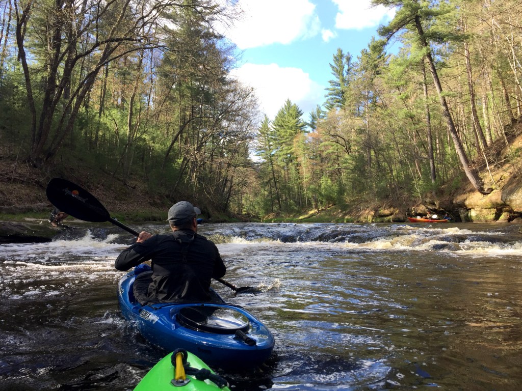
Once you’re on the water you’re immediately greeted by riffles and swift currents and you might not know it yet but you’re in for something special because a narrow and canopied creek awaits with gentle riffles ready to carry you onto bigger and more beautiful scenery. It’s quite inviting and it just doesn’t quit. It’s corner after corner of something new to look at or currents to negotiate.
The water changes from clear and clean to brown muddy root beer (most likely due to all the recent rain) which is common to the creeks in this area and very different than the black of, well, the Black river.
I was surprised by the width of the creek. It’s much wider than I expected, having Robinson Creek on my mind as the only other paddle in the area to compare it to. It’s not like Robinson at all – in fact, it’s completely different. Robinson is more intimate with less of the majestic rock formations. Halls is much wider and just a bit more breathtaking with every turn.
And it’s not Carroll Creek even though I wanted to compare the two because it shares so many similarities with its rock formations and constant riffles. For my money, this holds an edge on both the Robinson and Carroll but shares similarities to both. It’s just a helluva lot of fun.
Prior to Garage Road, there was one tree to portage. Well, it appeared to be a portage at least. Turns out, it can be limboed under river-right, something I didn’t think was possible until I was standing on the log and watched Timothy float under unscathed.
Past Garage Road, where again, it gets arguably more technical, there are three distinct ledges but there’s space between them (they’re not consecutively on top of one another) so all can be scouted and portaged.
The first, is a former dam. On river-left is a concrete slab that makes a very convenient slide – a little chutes and ladders if you will – with a bump in the middle. It’s pretty easy but it can also be portaged river-right with some creative climbing and scooting.
The next two are before the County Road E bridge and are nearly consecutive. The first is more of a traditional drop which should be scouted on river-right. There are a few different lines to choose (in fact, Timothy ran it twice for varieties sake). I chose the pool which was a blast. This is easy to scout and portage if need be.
The third and final drop is a few hundred yards downstream from the second and it’s more or less a gradual slope. I likened it to a shallow gravel driveway incline because I was scraping and scratching my way down. We both ran it river-right where it’s also easy to portage. Though it’s not challenging, it’s often scrap-ey in low levels and you’ll want to find the path of list resistance (which was the middle on this day).
That’s where we thought all the excitement would end but again, this creek doesn’t quit and Halls continues to surprise. Figuring we were nearing the confluence with the Black where the current would slow down, we were both caught off guard by a boulder garden lying just beneath the surface on our approach to County Road E. Neither of us lost it but it was touch and go there for a bit. It was a good reminder to not get too complacent and keep seated until the ride is over folks. In hindsight, we probably should’ve expected the boulder garden since this is where the visual gauge is located looking down from the bridge.
Finally, just past County E and before the confluence and take-out on the Black River is an impressive natural spring/waterfall flowing down from high above onto some large slabs of rock on river-right. It’s one last wink from Halls before the end of a special trip. Halls made us feel like we were welcome company with this last send off. It was an unexpected and pleasant surprise capping off an exciting trip.
Just a few more paddle strokes and you’ll spot the Black, in all its true blackness and noticeable contrast to the brown of Halls. The Black River itself, was raging after a couple weeks of rain so paddling to the take-out situated right at the confluence took one of us (ahem, me) for a ride (had it not already been a perfect paddle, I might’ve continued downstream to who knows where?).
The take-out is a legit landing on the Black River, officially named Hall’s Creek. The landing is paved, making for a very easy and accessible exit. There are no facilities but plenty of parking.
What we liked:
Every inch of this water. Halls Creek is as good as it gets for creeking in Wisconsin.
What you’re treated to is a simply engaging environment on a creek that is never very wide. You’ll float atop copper-hued water, over sand and stone, while discovering countless rock formations and outcrops that form small canyon-like bends and halls. There are numerous seeps and a few side streams (one in particular is a treat to explore). Often tree-lined, with sandbars that part the turns, it’s a photogenic feast throughout. It’s almost the perfect creek if there was such a thing, in my opinion.
In fact, we had some discussion about what was better – Morrison, Halls or Robinson? (which we revisited the following day) I’ve often said Halls Creek is my favorite but it’s kind of a pointless discussion as they are all different by more than a couple degrees – each with unique characteristics. And of course, water levels play into the kind of experience you’ll encounter on any given day. The best part of the argument is that you really have to paddle them all to have even have the argument, so in the end, you win by just paddling them. And even then, when you can make your case for favorite, it’s like choosing your favorite child. Impossible.
But for us, it didn’t stop there, we witnessed something extra special. While paddling into the Black River, I was leading the way. I glanced upriver and noticed some tan spots in the distance mid-river. Not thinking much of it, I turned my gaze downriver thinking they were logs or something until I heard “Elk!”. I spun my head around and sure enough, they weren’t logs – it was a herd of 6-8 Elk crossing the Black River in a single file line. The leader of the pack tried to lunge up the muddy bank but slipped back down into the water which gave us some extra time to stare and appreciate the sheer size of them. We were a distance from them but they still appeared huge, leaving it to our imaginations as to how we’d size up if we were standing next to one. The first one eventually made its way, as did the others, and they carried on into the woods.
There was a fisherman on the opposite side of the Halls Creek bank who witnessed it too. He said he’s been fishing there for 10 years and had never seen elk there. It was pretty amazing and though most of us snapped shots on our phones, we were just too far. Luckily, Timothy (who coincidentally was pulling up the rear) caught the backend of one. Fitting, right?
After I posted the shot on Facebook, there was a comment that they were recently introduced to Jackson County and sure enough, that would explain it.
Lastly, there were no portages to contend with this visit, save for a couple newly-fallen trees. One we trimmed, (before and after) and the other (a casualty of erosion) can paddled around.
What we didn’t like:
The unexplainable aspect to this trip were the water levels. The area had plenty of rain recently. The usual suspects that are historically water dependent were up and paddable, (Morrison was rocking, Robinson was frisky and a few of us paddled the East Fork – and if the East Fork rapids are runnable, you know the water is up) so we figured Halls would be too. But it wasn’t. Everything was up except Halls. It was almost the same on the visual gauge as our Halls Creek II report – so it definitely didn’t equate to the fun we had on our first trip in higher levels. Our educated-hunch is that the dam affects Halls more than we thought and that the correlated gauges mean very little (but at least we have the visual gauge to go on). So Halls took us by surprise and the only thing we can figure is that the dam had everything to do with the levels.
Though Halls is so damn beautiful, it hardly matters what the levels are.
Oh, we also didn’t like how cheaply crafted this pie iron was. (I mean – it’s meant to go in fire, you’re not suppose to break off because of fire!)
If we did this trip again:
For first timers, it’s still glorious – even in low-water. For repeat visitors, with some perspective on how it runs in higher levels, this trip (while still beautiful) leaves you longing for more because you know how much more fun it can be.
Either way, Halls Creek is a special paddle, and one to return to again and again.
***************
Related Information:
Camp: Black River State Forest
General: American Whitewater
Good People: Friends of the Black River
Map: Friends of the Black River
Map: Wisconsin DNR
Wikipedia: Black River
Miles Paddled Video:
Photo Gallery:


Previous Trip Report:
June 28, 2014
☆ ☆ ☆ ☆ ☆
Halls is a creek for creek lovers and it’s exactly the kind of destination that keeps us searching for the next great paddle.
It’s exciting but not overly-complicated. With near constant riffles and Class Is, a few exhilarating (but manageable) drops, natural springs that trickle down the banks into beautifully cut sandbars and pools and endless, sometimes jaw-dropping, rock formations in a canyon-like setting, it has everything you’d ever want but are unlikely to expect from a creek. It’s a thing of beauty.
Gauge Recorded on this Trip:
Neillsville (Black River): ht/ft: 6.68 | cfs: 2,160
Time: Put in at 12:25p. Out at 4:05p.
Total Time: 3h 40m
Wildlife: A blue-winged teal, an osprey, two deer and a bald eagle.
Ever since paddling Robinson Creek back in 2012, the next must-paddle destination in the Black River Falls area was Halls Creek. Spotted on a map given to me by the Park Ranger at the Black River Falls East Fork Campground, (and subsequently destroyed in that night’s rains) I knew there was more to these feeder creeks that needed exploration.
Halls, like Robinson, typically has very little water this late in the season to paddle. Part luck, part global warming, here we were in late June with enough water to give it a run.
The night before we left, the Neilsville gauge unexpectedly shot up over two grand (some lingo I picked up on this trip and will adopt henceforth) in the overnight hours. Karma was clearly on our side when that gauge moved from 5.3 to 6.68 in depth and 1200cfs to running 2160cfs. It was meant to be…
Now, in reality, the gauge has arguable correlation to the creek, as Halls is controlled by a dam and it is the Neilsville gauge (on the Black, much further upriver) but for our own benchmark and the recommendations via American Whitewater, it’s what we have to go on for comparison’s sake. If anything, it’ll give you an idea if there’s been recent water in the area.
We, of course, were going regardless of levels (because we’re stubborn like that) but damn did we get lucky with that late-water arrival because the levels were perfect and I can’t imagine (nor recommend) paddling this at lower levels. We rarely scraped but it could be a potential walker at lower levels.
So me and fellow-Miles Paddler, Timothy, set out to feast on the beauty that is Halls.
What we liked:
There probably aren’t enough superlatives to describe how fun and naturally breathtaking it really is. It’s the pinnacle of creek paddling for me, personally. This creek doesn’t quit and you’ll be rubber-necking the entire way as you make your way past canyon walls, through seemingly non-stop riffles or splashy Class Is. You’ll pass numerous natural springs that create little photographic nooks and inlets and the occasional small waterfall. Capped off by three exciting drops between Garage Road and the take-out, this is like a movie you’ll want to rewatch as soon as you’re finished.
We met a friendly local at the put-in who told us we were going to love it. He was about to take a friend down Halls but was taking-out at Garage Road because his buddy was new to kayaking. He told us that below Garage, the paddling is a bit more technical. After running it, I’m not convinced it was anymore technical than the first four miles but one man’s technical is another man’s median (and at this point, we’re probably just splitting hairs). However, the three drops that reside on the downstream side of Garage are indeed, drops, so he was probably (and correctly) erring on the side of caution.
Fun fact about this guy. He’s got his own unique bike shuttling setup. A van with enough room for his kayaks and a moped (this being the first moped shuttler I’ve met).
The section to Garage road is indeed great for beginners but it would be hard to recommend this creek without recommending the whole stretch. It’s just too damn beautiful and since the drops are easy to run, they are similarly easy to portage if you wanted to opt out. Plus, it only took us an hour to paddle to Garage Road in these water levels. Much too short of a trip if you’re making the drive to the Black River Falls Area.
Unrelated to the paddle and on our way to the campground, we detoured to the Black near the dam to scout the rapids. There, we met some folks from Milwaukee, one a serious whitewater kayaker who was scouting the rapids for a potential run. We hiked for about an hour, in awe of the massive amount of water churning downstream. He pointed out the lines (or lacktherof) he was looking for and explained the classes at each section, including a class V+ that had his gears turning. We watched as this guy struggled with an internal argument over the reality of successfully running it. Who knows if he did (he had planned for the Monday after that). Check out some of the scouting pics here, here, here and here.
We spent the night at campsite #9 at the Black River East Fork Campground, one of my favorite places to tent when you’re riverside. For me, there’s nothing better than fishing from your campsite (sorry to the walleye I accidentally murdered). A storm rolled in that night, which led to some creative emergency shelter building/scrambling but that just made the day even more memorable. More importantly, it was keeping the water levels up in the area (and for the next day’s paddle too).
Lastly, of all the things “We Liked,” I’d be remiss if I didn’t mention that it was on that night, I had my first ever homemade She-Meh-Neh burrito over an open-fire (Burrito Drive fans will understand the impressive nature of this feat). I didn’t even know it could be done but Timothy outdid himself and solidified his status as camp chef from here on out (kidding, I’ll help, if I have to).
What we didn’t like:
This is the least I’ve ever written about “didn’t like”. There really isn’t much to say. We saw very little wildlife but I’m stretching here – there’s just too damn much to look at and love otherwise.
If we did this trip again:
I’d go again in a heartbeat. The weather was perfect, the water was perfect and it doesn’t get much better than this for creek connoisseurs and lovers alike. It’s worth calling in sick to work if the water is up.
Miles Paddled Video:
Photo Gallery:


Alternate Trip Report: Shorter Paddle (7.5 Miles)
Garage Road to Halls Creek Landing
August 9, 2015
☆ ☆ ☆ ☆ ☆
An impromptu redo of what may well be our favorite stream anywhere (and quite possibly, in all of Southern Wisconsin), Halls Creek is simply incredible on all accounts.
Gauge Recorded on this Trip:
Neillsville (Black River): ht/ft: 3.5 | cfs: 200
Put-In:
Garage Road, Merrillan, Wisconsin
GPS: 44.40522, -90.80502
Take-Out:
Halls Creek Landing, off County Road E, Black River Falls
GPS: 44.3588, -90.78455
Time: Put in at 11:25a. Out at 2:50p.
Total Time: 3h 25m
Miles Paddled: 7.5
Wildlife:
Songbirds, bald eagle, toads, great blue heron and muskrats.
Background:
This return review really is intended to discuss various water levels and how Halls feels at higher and lower rates.
Making the most of being in the area still after our fun trip down the Black River the day before, the Sunday morning question over coffee and quiche at the always delightful Molly’s on Highway 12/27 (aka Water Street) was where to paddle today? I myself still have both individual segments and whole streams yet to be discovered in the area – Morrison and Robinson Creeks, the East Fork of the Black – and going somewhere new always is my favorite thing to do, but seeing if Halls Creek was runnable made the most sense for the least amount of driving and the best paddling landscape. Plus neither of my two friends I was with knew anything about Halls Creek. And my second favorite thing to do is go to somewhere “knew” – by which I mean a place I know and cherish together with the rich opportunity to share that special and spectacular place with someone for whom it is their first time, their eyes wide with wonder, their slack jaws forming smiles from ear to ear. Halls Creek is that place.
For better or worse, the conventional correlative gauge for Halls Creek – indeed, for all of the Black River Falls area tributaries of the Black River – is the USGS gauge for the Black River in Neillsville. This is problematic for a number of reasons, namely that the Black River itself is so much bigger and drains such a larger watershed than any of its individual tributaries, most of it coming from way upstream.
On top of that, Neillsville itself is at least 30 miles to the north, and just because it rains up there does not necessarily mean you can skip watering your garden in parts down south. You should at least consult the NOAA gauge on the East Fork of the Black River, which is geographically closer while measuring a more comparable watershed and compare it with the USGS gauge.
But if you’re already in the area, the very best way to determine whether Halls Creek is runnable is to check the visual gauge on the water itself at the County Road E bridge. Look for the large rock in the middle of the streamed on the upstream side of the bridge. If you can’t even see the rock, you’ll have more than enough water – and a wild ride! If just the tip is exposed, you’ll be in great shape. If it looks like the photo below (or here) when we ran Halls Creek this second time, you’ll scrape here and there, and the latter two of the three total ledges will be too low to run comfortably.
Halls Creek is luxuriously exquisite, but because it is so tricky to catch at a runnable level I would say you should try your luck even at as low a level as we did for this trip, even though ordinarily I would argue that you should wait til it’s a smidge higher.
One last consideration. When Barry and I ran this last year, the water reading on the Neillsville gauge was bonkers high at 2,160 cfs. By contrast, the same gauge was sputtering at a skimpy 200 cfs when I was contemplating Halls Creek again, a dramatic difference of more than ten times less volume. But this discrepancy in no way correlated to such less water on Halls Creek. Halls was definitely lower this time around than when we ran it last year, but not to the point of negation.
This is what makes correlating water levels a very imprecise, very relative exercise. To be sure, if you’re not in the area already, correlating is better than nothing. But the way one gauge reads with respect to the current conditions on a separate stream should be taken with a grain or few of salt. Normally, I would never consider doing Halls Creek if the Neillsville gauge is at 200 cfs. But we were only a few miles away, so we had the privilege of eyeballing the level directly. I was shocked that, low as it was, it could still be run.
OK, one more one last consideration. The day before, while paddling down the Black, we took a break at the Halls Creek landing to have lunch. As we did so four whitewater paddlers decked out in hardcore gear and clearly experienced were just ending their trip on Halls. I asked how their run was and the water level and they reported that both were great. But the creek did drop in the span of those 24 hours, so keep that in mind as well – it drains fast.
And even one more little water-level postscript to this trip. One day after we’d paddled this the Neillsville gauge recorded 0.8” of rain, resulting in the river rising three feet! This doesn’t always mean that x amount of rain equals x amount of feet the river will rise, but it does provide a rudimentary ratio. At the very least, it’s correlative, not causal, as the scientists like to say. And guesstimating river levels where there are no gauges is as much an art as it is a science. So, we ended up missing that rush of rising water by a day. But them’s the breaks in the whitewater game. Not unlike new snow for XC skiing, paddling is a commitment to carpe diem. Go when the muse commands. She won’t wait for you to dance til you’re ready.
What we liked:
Halls Creek has everything a paddler will fall in love with: clear water, a sandy-rocky bottom, a mini-canyon gorge environment with endless rock outcroppings, and constantly swift current – too many riffles and Class I rapids to count, three outstanding Class II ledges in the last three miles before its confluence at the Black River. Throw in many weeping seeps, a couple mini-waterfalls, great wildlife and generally very little development in a forested setting, it’s really a slice of heaven.
For this trip we paddled the second “half” of Halls Creek, from Garage Road to the Black River, rather than begin below the dam upstream, since we were starting late and still had to drive 2 hours back to Madison (on a Sunday afternoon with all the Dells exiles returning to Illinois). This is unquestionably the better stretch of Halls Creek. It had been a kind of “welcome to whitewater” weekend as it was, with one of my friends paddling Class II for the first time the day before and the other feeling more comfortable in Class I+ conditions. Halls Creek is a great place for these platforms, even the three ledges, as each of them can be portaged if so desired.
Speaking of which, the third of these three ledges was quite different than when Barry and I had paddled it last year. Indeed, we kept punning the word “allegedly” because we never really found it. In retrospect, it must have mostly washed out in the higher level, because this time around, at a lower level, the ledge was clear as day but too shallow to run without scraping the heck out of your boat. There’s just not enough water to carry you over comfortably, so the three of us ended up awkwardly and inelegantly nudging our ways forward and down. More comical-debacle than adrenaline rush.
All that said, if you have the time, you should definitely begin your trip below the dam and run the full course of Halls Creek to the Black River. The water is beautiful and swift upstream and the landscape is still picturesque. But if you have only so much time and are mainly interested in the brawnier rapids, then skip the first four miles and begin at Garage Road. There’s a trampled down path to the river and a perfectly adequate launching spot off the grass on the upstream side of the bridge on river-left. There’s even a convenient spot to park a car just off the road.
What we didn’t like:
Just the low water level but that’s not the creek’s fault. The paddling was more thrilling last year, with more water rushing through but this year’s run was still tremendous fun!
If we did this trip again:
We’ll often return to do Halls Creek, whenever she’s up and running.
Photo Gallery:


11 Comments
Chris Vander Ark
May 21, 2015 at 2:49 pmI did this same section yesterday morning. The Black River Neillsville gage was less than 3.6, and while I wouldn't recommend this for others, or do it again at this level, I'm so glad I went. Yes, it was "low and scrapey," as the Friends of the Black River paddling brochure puts it, because of no recent rain, and I got hung up innumerable times. But it was still a stunning morning on the water, with the deer and bald eagles around. The bike commute would have been not doable but there was so little traffic on the stretches of highways E and K that I was only passed twice by cars. The cold, 32 degrees when I started out, kept things interesting. A great morning overall.
Miles Paddled
May 22, 2015 at 12:23 amGlad you made it Chris! Bummed I couldn't partake. Great to have a low-gauge note for future reference. Happy to hear it was a good trip despite the scraping and temperature!
Miles Paddled
June 12, 2015 at 11:46 pmNot a problem RATMescher! Thank you for posting an update and you're absolutely right – there's a lot to check out in that area. Can't wait to do it again. This weekend looks great for a visit. Have a great time!
RATMescher
June 14, 2015 at 4:53 amThanks so much for writing this review! Last year after seeing this post we ran it with the gauge at about 6.5 ft and it was the best paddling experience of my life (so far). We are doing it again this weekend, and can't wait to try out Morisson and other creeks in that area. With the mountain biking and the paddling right next to each other it's a little slice of heaven.
Ram bling
June 14, 2015 at 4:53 amRATMescher, if you're into mountain biking, then you must know Levis/ Trow Mounds. Great little secret spot with awesome trails and lookouts where you'd think you're out in the mountains. If you're into XC skiing, the Wildcat trail in the state forest off Smrekar Rd is one of the best anywhere in the state, south or north. The BRF area is probably my single favorite place in all Wisconsin. Don't forget about Robinson Creek or even Perry Creek (the last half-mile is paddleable in high water) and falls over 3-4 super-fun drops. Anyway, enjoy this weekend and let us know where you went and how it was. Water levels should be supreme!
RATMescher
June 18, 2015 at 6:00 pmOh yes, I know all about Levis, it is the greatest. I will check out Perry next time for sure especially if it's just a short run to do after another creek.I don't want to write my own travel blog in the comments here, but here are a couple tips:East Fork campground is great and you will always find a site. Aside from holiday weekends you are virtually guaranteed to find a site at any time. Even holidays, if you get there on Friday I have never seen it fill up. We nabbed the coveted site 13 this time out! the pup. Kathy's Animal Ark is literally on the shuttle route for Hall's Creek. Super duper affordable too! They are only open till 4pm and I think closed Sunday and Monday so if you're going for a long weekend with the pup, head out Thursday instead. Get an early start to make sure you get back by 4 and leave a tip! Tell them Stein sent you.Also, be sure to take an early morning paddle on the East Fork if you're at the campground. Put in at East Fork Rd and take out at your campsite. An easy bike shuttle to get back too. There are 3 simple class 1 rapids in a short 45 minute stretch of the river, a good way to start the day. I get up early camping so I was in the water at 7 and out at 8, packed up the campsite and was off to Levis. A great sendoff for the weekend!The Neillsville gauge isn't all that accurate for Hall's but it's the best we have. The gauge was lower this time than last, but the levels were higher. I noticed the gauge peaked right after the rain and immediately fell down and plateaued. To me that means they opened the dam at Arbutus to drain excess water, which has no effect on the creeks. Something to keep in mind.Oh no, I gave away all the secrets. Oh well, the more the merrier (unless you steal site 13 from me…).
Ram bling
June 18, 2015 at 8:05 pmOh, we know about the beloved E. Fork Campground, stayed there last year after we ran Halls Creek, and then did a short clip of the E. Fork itself the following morning. We love the place! Been itching to check out the real whitewater on the E. Fork further upstream, putting in at Steponik or even Knutes. Ever hear of Rock Creek? It enters the E. Fork just upstream of E. Fork Rd on river-right (from the north). We scouted a short 5-mile section of it last year. Looks like it has some real potential, though downed trees are almost certain.As for correlating, I think the NOAA gauge for the E. Fork is likely the best way to tell what Robinson Creek is doing. The E. Fork is much wider, but the two are comparable in other regards. Morrison, like Halls, is more of a crap shoot, unfortunately.I think the Hatfield Dam still has scheduled releases once a month, right? We saw it roaring at Class V last year when Neillsville read 2160 cfs, and it was truly ferocious — a little Grand Canyon in Jackson County.Finally, Perry Creek is really a lark. You'd have to schlep your boat a couple hundred yards from the parking area at its mouth, over the pedestrian bridge, then up the hiking trail, and then commando launch from wherever you felt like it. It's gorgeous though and looks fun as hell. But you'd need to catch it right after a good rain, or it will be too low.
Jim Johnson
May 21, 2017 at 8:35 pmDid Hall’s Creek today. Gauge read nearly 9′ & discharge 4,000. Lots of pushy water. According to the flattened vegetation along side the creek it was 2-3 feet higher a couple of days ago. It’s neat to paddle downhill for an entire trip; almost no flat water. I handled everything but that last drop which suprised & dumped me. I had to chuck my paddle in order to catch the boat (& save myself). Quite a bummer after that. Luckily, from that point to the take-out wasn’t much more than a mile. My “Aquapac” brand”waterproof” phone bag prooved to be unworthy. The unitiatiated should know to use a skirt; I would have been swamped a dozen times had I not.
Timothy Bauer
May 29, 2024 at 10:00 amWe returned to Halls for a Memorial Day paddle after three separate rain events in the course of seven days (including the day before our trip). The visual gauge rock upstream of County E was just barely totally covered. Since the water color is tannin-clear, you could see the rock from the bridge (especially if you know where to look), but you could see that it was covered. In other words, a higher than normal and therefore excellent water level. From the dam to Garage Road is nearly nonstop Class I fun. The first ledge was read on the fly, as there was nowhere to get out and scout. This is the one where a dam was mostly removed, with a cushy chute center-left that is pretty intuitive. The other two ledges could be scouted and/or portaged. Even at our high water level, there was still some scraping going down these, which surprised us. Maybe “the rock” needs to be totally invisible…
Considerable thanks goes to Jeff P and the river angels crew for clearing out fallen trees and dangerous strainers — especially after 100 mph winds and a lot of rain the last few days! We didn’t have to portage or worry about a single obstacle (except for the ledges). Please consider reaching out and/or donating to the Friends of the Black River for their tireless sweat equity making places like Halls, Robinson, and Morrison safe and exhilarating paddle trips. Rivers clear of clutter don’t just happen; volunteers make them happen, at no small expense of their own time and personal comfort. https://www.friendsoftheblackriver.org/
Nicole T
July 6, 2024 at 5:57 pmDid garage road to Hall Creek Landing today and the Black River at Neillsville was approximately 2200 cfs. So current was moving and the trip took us only 2 hours! The drops were a blast. Those with rec kayaks and no skirts definitely filled up or tipped ( other groups we saw). Beautiful paddle but too fast for to many photos today.
Timothy Bauer
July 7, 2024 at 9:11 pmRight on, Nicole! (Write on?) Two hours is pretty fast for that section. Water levels have been fantastic this year. But kayaks without skirts on the three ledges is asking for trouble… Glad y’all had a great time!