Watersmeet to Forest Road 5250:
An amazing day-trip down a beautiful river located within the Ottawa National Forest, the Ontonagon has it all: peaceful flat water sections, whitewater up to class II and a waterfall to boot. Fun, rejuvenating and just challenging enough for paddlers new to whitewater.
By Trevor Bellrichard & ‘A’
Miles Paddled contributors
Rating: ☆ ☆ ☆ ☆ ☆
Trip Report Date: August 12, 2017
Skill Level: Expert
Class Difficulty: II(III)
Gradient:
9′ per mile average, 21′ per mile maximum
Gauge Recorded on this Trip:
Paulding: ht/ft: 4.25 | cfs: 165
Recommended Levels:
A little low but still great and a normal summer level. 180cfs would be a great time and still doable.
Put-In:
Designated canoe access just south of Highway 45, Watersmeet, Michigan
GPS: 46.27471, -89.17656
Take-Out:
Forest Road 5250, northeast of Watersmeet
GPS: 46.35672, -89.07679
Time: Put in at 11:40a. Out at 5:50p.
Total Time: 6h 10m
Miles Paddled: 16.25
Wildlife:
Wood ducks galore, a few turtles, one whitetail deer and free range children.
Shuttle Information:
The drive from put-in and take-out is 40 minutes round trip. Bob at Sylvania Outfitters is very free with information and if you don’t want to use your own vehicles or boats, give him a call.
Background:
This was a long overdue trip to visit a good friend who recently moved to Michigan’s upper peninsula. We paddled this particular river because it offered us a more challenging paddle than what southeast Wisconsin has to offer without being more than we could handle.
Overview:
This was such a fun trip! Whitewater of this scale (class II max if you don’t run Max-i-min-e Falls) was a great introduction to the experienced flat water paddler (but whitewater-curious adventurer) who was ready for something different.
The put-in location on this branch of the Ontanagon is only four hours north of Madison (we say only because we assumed the drive would be much longer). The put-in itself, just south of the Highway 45 bridge is very well marked with parking for a handful of cars. There’s a twenty-foot mowed grass trail which helps make getting your gear down a hill to the bank a little easier.
The river starts narrow with alder covering the banks and branches extending a foot or two over the water. The growth makes it feel a little crowded at times and I started to wonder, what are we doing here? In this section, 15-20 wood ducks were roosting in the alders and burst out as we passed. The first “whitewater” we came to was manmade and unexpected – that being a 2-foot ledge located between concrete pilings which gave us a long pause. We surveyed the area for ten minutes, trying to decide if we should run it or not. The kayak in our group went first without incident. It was actually a fun concrete slide with water moving quickly over it. The canoe made it through but just barely – it’s a tight squeeze on both sides. This feature could create dangerous hydraulics in high water, so be cautious.
You’ll come to your first real whitewater about three miles into the trip. It begins with small riffles and increases to low grade class II rapids around a left hand corner. (There also happens to be a house right on this corner, what an amazing place to live!) The way through the rapids is obvious and it’s fun to get your first taste so early on in the trip.
The riffles end after a quarter-mile and then it’s flat water paddling for quite some time. You’ll pass below two bridges, one at mile four and another at mile six and a half. The second bridge is a trail for ATVs and off-road bikes. From there, the river slows way down and in about another mile, you’ll encounter an enormous bed of wild rice. Enormous like, the river disappears and you are paddling IN wild rice, enormous. There’s a house on the river/rice-right shore and some folks shouted that we should come their way. Exiting what felt like a prairie growing in the river, we eventually found the channel. Our advice would be to stay river-right, through this section.
In a mile you’ll come to a tall railroad bridge and the river starts to speed up. We saw a whitetail feeding in the shallows there. It was a pretty sight – towering trees, whitetail in the river, boulder garden – amazing. The river speeds up due to the “waterfall” ahead (we were told it’s more accurately a class III+ rapid). But before that, there are a few boulder gardens that lie just ahead and then a couple of class I rapids. Mid-river you’ll see a sign for the “Tamarack Creek” takeout. Just past this, three-quarters of a mile ahead, you’ll eventually come to Max-i-min-e Falls. There’s a large rock peninsula that juts out from river-left, which means you’ll need to squeeze through on the right and then stay on the river-right shore to the portage.
Max-i-min-e Falls is impressive and it’s possible to see how a braver soul could run this. Not for us though, we took the 20 rod portage around. Above the falls is a great place to sit on a rock and have lunch, though.
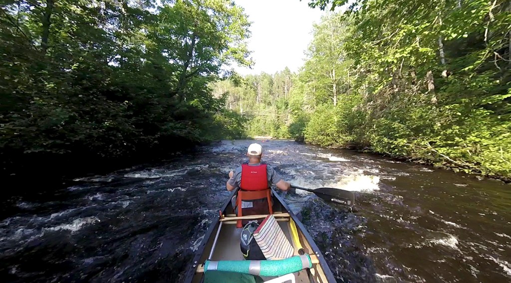
Below the falls, the real fun begins. The river is lively and full of class I and II rapids all the way to the takeout. You’ll get breaks between runs to enjoy paddling through National Forest on all sides. It’s easy for your mind to wander staring at the towering pines and tall rock outcrops, but you’re often brought back to the present when you hear that low roar of another rapid ahead.
At this water level, nothing below the falls required scouting before running. There were a few ledges and tricky spots that in high water might give pause, but nothing dangerous. Any less water and you would hit every rock for the next six miles. This was one of most fun stretches of river we have ever paddled and we cannot recommend it any higher. Almost constant rapids for three hours!! Who can argue with that?
The take-out is at the only bridge you’ll encounter after the falls. The access is on river-right after a stretch of rapids and right-turn horseshoe but it’s all very accommodating to easy exiting and enjoying a celebratory drink of your choosing.
What we liked:
We loved it all.
What we didn’t like:
Since we now know what this section of the Ontonagon has to offer, we would probably skip the stretch of river above Max-i-min-e Falls. There were many long periods of paddling slow straightaways with not much on shore to hold our interest. That said, we felt accomplished because we paddled the upper section and would have always wondered what it offered, had we not.
For more information, check out this explanation of the trip in its entirety (scroll to the bottom and combine trips #2 and #3).
If we did this trip again:
We would love to do this trip again. When we do, kayaks will be the boat of choice. Considering that this was our first time paddling water like this, we were happy to have the familiarity and stability of our canoe. However, at times, the canoe was cumbersome and slow in responding. If you love your canoe and like doing things the traditional way, go for it. We proved it can be done. If you don’t feel one way or the other, do it in a kayak.
***************
Related Information:
General: American Whitewater
Outfitter: Sylvania Outfitters
Wikipedia: Ontonagon River
Photo Gallery:


No Comments