Steponik Road to Overguard Road:
A beautiful and almost entirely undeveloped swath of classic central Wisconsin landscape featuring tall pines, root beer-hued water, and modest granite outcrops, this section of the Black River’s East Fork is characterized by calm quietwater with an occasional riffle every few miles that’s perfect for beginners and canoeists. The one notable exception is a 1,000′-long segment of Class II rapids leading to a Class III ledge at so-called East Fork Falls that should be done only by experienced paddlers in closed boats.
Rating: ☆ ☆ ☆ ☆
Trip Report Date: May 4, 2019
Skill Level: Beginner for virtually everything. Experienced for East Fork Falls.
Class Difficulty: Quietwater with occasional riffles, except for the Class II-III rapids at East Fork Falls.
Gradient:
4′ per mile for most of the trip, except for approximately 15′ per mile at East Fork Falls.
Gauge Recorded on this Trip:
East Fork Black River: ht/ft: 894.85 | cfs: 259
Recommended Levels:
We strongly recommend this level. I got lucky and hit this at a great level. The day before I paddled it, the river was running at 200 cfs. It rose to 260 cfs while I was on it, but then dropped to 169 cfs (or 5″) the next day.
Put-In:
Steponik Road, east of Pray, Wisconsin
GPS: 44.37479, -90.44682
Take-Out:
Overguard Road, Black River Falls Area/Hatfield, Wisconsin
GPS: 44.41111, -90.59917
Time: Put in at 1:25p. Out at 5:00p.
Total Time: 3h 35m
Miles Paddled: 11.5
Wildlife:
Deer, turkey vultures, hawks, bald eagles, wood ducks and leatherback turtles.
Shuttle Information:
10.7 miles, all of it dirt/gravel roads, doable on knobby bike tires but not much fun.
Background:
It’s easy to overlook the East Fork. Nowhere near as showy as the Black River’s other neighborhood tributaries – like Halls, Morrison, Robinson, or Wedges Creeks – and far more monotonous and tame than the more rambunctious sections of the Black River itself, the East Fork is that proverbial redheaded stepchild in the Jackson County Family Five. But it is a beauty in its own right, even if it doesn’t stand a chance next to its siblings. I mean, surely there’s got to be a Neville or Marsalis who’s a fine musician – a great one by any conventional standard – who’s perfectly content to garden or do carpentry instead of sharing the spotlight with its more prodigious sibs, right?
Paddlers are drawn to the East Fork for two reasons: its unspoiled landscape and its occasional rapids. Whether your trip is seven, eleven, fifteen, or even more miles, there’s virtually no development along the banks. Instead, you’re treated to a continuous flow of conifers along public land, beguiling backwaters and hollows, lots of little riffles, and a smattering of modest rock outcrops. As for the rapids, there are two notable sections: from Steponik to Pray roads (Class II-III) and then, further downstream, Overguard Road to the campground/boat launch (Class I-II).
We first paddled a short segment of the East Fork back in 2014. Because accesses are essentially few and far between, we opted for putting-in at Overguard Road and taking-out at the official boat launch at the campground for what ended up being a 4.5-mile trip that took us only an hour and a half to paddle. At the time, our reference was Michael Duncanson’s Canoeing Guide to the Indian Head Rivers of West Central Wisconsin, a slim little periodical that’s as adorable as it is admirable in its outdated nature. (Published before we were even born, the guidebook is totally old-school: everybody in the photos is skinny and toned and wearing cut-off jean shorts, having at 25-mile-long day trips like a walk in the park – back when you just paddled all day because that’s what people used to do before we had to be plugged into bells, whistles, buzzes, and dings from our phones – while the maps are innocently before the time of GPS coordinates and are oriented from the perspective of a paddler going downstream as opposed to the more conventional bird’s-eye-view.)
That trip was too short, but at the time we didn’t have the time to re-shuttle and tack on an addendum segment upstream. So it was that we’d have to wait til the time was right to come back to the East Fork to further explore it. That time came five years later via the old adage “when a door closes, a window opens” (or however that saying goes). The original paddling plan met a plot twist at the 11thhour, but this turned out to be pure serendipity. Friends of mine had already planned on kayak-fishing the East Fork for the opening weekend of fishing, putting in at Overguard and drifting down to the boat launch, just as Barry and I had done years before (sans rods). I knew I wanted to end my trip at Overguard, in order to complete the link upstream. I also knew that my friends would be waking up at the crack of crack to be on the water early after driving from Madison (me, I like to ease into the morning with that one and only cup of coffee and take my time before getting into the car).
So, I drove up to Overguard Road, found one of their cars (they were still on the water somewhere), and left my spare car key with a handwritten note asking them to find my car at the put-in, at Steponik Road, and then drive it back down to Overguard so that it would be there for me at the end of my trip. No phone calls, no text messages – just a key wrapped up in a note and a gentleman’s word. A small article of faith. The way shuttles used to be done back in the ‘70s and ‘80s. I think Mr. Duncanson would’ve been proud.
Overview:
Assuming you’ll first leave a vehicle (or bike – but bike shuttling for this trip is pretty awful on account of the gravel-dirt roads) at the take-out at Overguard Road before moseying up to Steponik, let us first say a few words about these access points. Both are dead-end roads that lead to/close to the river. The river runs east-west, both of these roads head due north. At Overguard, the take-out, you’ll drive down it as far as you can until you just can’t anymore (or shouldn’t), and there you’ll find a space to park a vehicle or two. But before you leave, do yourself a favor and mark the spot by the water with a bandana, a balloon, a mosaic of shells so arranged as to read “Take-Out Here!” Whatever you got to catch your attention. Because it’s really easy to miss this nondescript spot from the water. And while it’s only some two miles to the next bridge, at East Fork Road, it would be a long and grumbling schlep of shame from there back to Overguard.
At Steponik, the put-in, it’s more or less the same matter with one difference: there’s a house to the left and for a moment you might worry about trespassing. But to the right of the address marker (N8381) you’ll find a distinct trail that leads to the water.
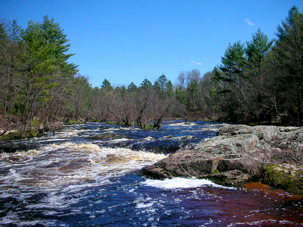
At the put-in the river looks deceptively bigger than it is due to a backwater. But here, as elsewhere, it’s about 50′ wide. Immediately, the view is gorgeous: root beer-hued water, gleaming green pines leaning river-ward from each bank, a deep blue sky (ideally), and brown ground teasing of hollers and hideaways. It’s truly a beautiful beginning to a trip.
The landscape itself will alternate between this iconic Central Wisconsin look to more of a floodplains feel, back and forth. A long, prominent slough will be found on the right, easily mistaken at first for a separate stream feeding the East Fork. The first “landmark” comes next, a red snowmobile bridge. Unless the river is crazy high, there should be no difficulties passing under it. The first of umpteen riffles follows this. Then an attractive sand bank appears on the right; about 200′ long and 10′ high, it adds an attractive accent to the scenery. Here, the river will meander some, then straighten up, only to curl with a zig and a zag again. The first small rock outcrops appear, on the right, and then some additional riffles on the left. This pattern will continue until you hear the unmistakable sound of real rapids, two miles from the put-in.
Meister Mike Svob unassumingly alludes to these as “a couple of Class II-III rapids (for skilled whitewater paddlers only)” in his “Other Trips” paragraph for the Neillsville-to-Lake Arbutus trip on the Black River in his good book, Paddling Southern Wisconsin. Sometimes, when we say “a couple” we mean a handful, right? Not a lot, but some. And then other times we mean literally two, one and then another, period. Svob must have meant the latter, because there’s “Whitetail Rapids” (Class II) immediately followed by “East Fork Falls” (Class III). Whitetail is a simple enough affair of pillowy haystacks you just plow into. A canoe’s bow might afford a more formidable cover, but for kayakers I strongly recommend wearing a spray skirt, unless you’re looking to get totally soaked and want to rinse out the inside of your cockpit with a couple gallons of water.
East Fork Falls is more nuanced. Scout it on the right bank. There are three ways to run this drop. From left to right they are as follows:
LEFT is the safest route that still provides a lot of splashy up and downs, together with river-reading and good boat control, but it’s essentially a Class II+;
MIDDLE is the solid Class III run with a smatter of massive granite slabs in the middle of the river and a diagonal ledge to the right of these outcrops with a very sticky-looking hole and backroller at the base, meaning this is the more complicated and least safe run (but the funnest probably);
RIGHT, where the run is Class I-II, with a series of modest ledges and boulders to dodge, but some straggler trees from the nearby right bank, which, in the swift current, you’d need to avoid, and to avoid, you’d need to be able to stop on a dime, pivot, steer away, etc.
Since I was paddling alone, I simply portaged around this whole affair and went on my merry way again.
Just kidding! Come on, I’m not “The Fanatic” for nothing! But I did run this on the left, since I was alone. Sure the middle looked fun as hell, but also dangerous and totally unwise since I was like Han from Star Wars and paddling Solo (it was May 4th, after all…). Or you can be less of a jackass/smartass and simply portage around the so-called falls via the right, where you’ll discern a feint trail. Conversely, you can use said feint trail to re-run the falls. Either way, there’s a delightful sandbar and small island on the downstream side, river-left, of the falls. It provides a great place to re-situate, dry off, take off your spray skirt (you won’t need it for the rest of the trip), and get close to the falls for a better view.
A very long straightaway follows the falls, nearly a mile long with hardly any bend or nuance to it. But then the river turns left, then right on its approach to the first – and only – bridge on this trip, at Pray Road. There’s perfectly adequate access on just about all sides of the bridge. Taking out here makes for a 4.4-mile trip.
More long straightaways are what you can expect downstream of Pray Road. It’s still very pretty, what with the pine-flanked banks… but it does get a tad monotonous. Out of nowhere a lodge of some sort will appear on the left bank. I don’t know if it’s private or public, but there is a prominent flagpole, which led to a hunch that it’s public (Jackson County Parks?). There was nobody around to ask. Following this are more riffles, modest rock outcrops, and pine-flanked banks going out like a surplus sale. The river does meander more after the lodge, which provides for a faster pace of current (but still no real rapids, just riffles). And some of the rock outcrops are more impressive than modest (but still not like those found on the Black River itself or its sublime tributaries).
After one prominent meander that more or less resembles a crooked right-hand index finger, a long straightaway leads to the totally inconspicuous take-out at Overguard Road. Just keep your eyes peeled for whatever you’d left earlier to indicate the spot. (You didn’t forget to do that, did you?)
And if you’re lucky like me, your car will be there waiting for you!
What we liked:
What’s not to like about virtually no development for 11.4 miles – just woods, moving current, and modest rock outcrops? That’s the real appeal to the East Fork, this upstream portion of it in particular. It’s a contemplative river, a Zen stream of mindfulness and being-there. The wildlife is wonderful – although neither elk nor wolves were seen this time around… The fishing is excellent. But really it’s the remoteness, the solitude, that makes the East Fork pretty enchanting.
Oh, and those rapids! Sure, it’s extremely brief, but it’s an exhilarating experience. There’s something so magnificently satisfying about running Class II-III whitewater that’s truly empowering. Neither Barry nor I think of ourselves as “whitewater paddlers.” We’re not, plain and simple. But we affectionately liken ourselves as “lightwater” paddlers. Class II-III rapids, in our opinion, are that edge between just plain dumb fun and a fundamental skill set of intelligence together with basic boat control to choose the best route and handle the conditions safely. Does it always work out that way? Of course not. But the point is to do one’s best with what one has. Like anything in life. Anyone can handle Whitetail Raids, but not everyone should attempt East Fork Falls without first scouting it and realistically being able to safely paddle its conditions.
What we didn’t like:
This section of the East Fork is like that kid at an amusement park who breaks her little bank on one expensive ride that’s thrilling but fleeting. For, as soon as it’s done, she learns that it’s all over much too soon, and now she’s got hours to go to just wander around before it’s time to leave the park. Sure, there are little riffles before the rapids, and there’s a handful of additional ones still after the rapids, but they’re nothing to write home about (or in a blog). From a geological perspective, it’s pretty interesting how minutely invested the rocks and gradient tumble are. Consider: but for a single 1000′-long spot, this 11.4-mile-long trip is totally tame and well-behaved. It’s just rambunctious as all get-out in one skinny little section. But from a paddler’s perspective, it’s a little disappointing that the hedge-fund managers bet the farm on East Fork Falls and then let everything else between Steponik and Overguard pass by overlooked.
Paddling a crossover kayak for 11.4 miles makes for a long day, and a workout, no two ways about it. The faulty boat choice was mine, and the whole time I wished I’d had taken up the solo canoe instead. Although it’s debatable at best whether I’d have paddled the rapids in the canoe, as I don’t have the right whitewater gear for the canoe – or paddling skills for canoeing in whitewater. And, frankly, that thousand-feet or so of wild water is the single-most fun part of this section of the East Fork (and anywhere on the East Fork in general). But the long, flat straightaways do get a little redundant after awhile, especially in a 9.5′ boat that is no more designed for this type of environment than is an AWD hatchback for a smooth interstate highway.
But this is really a minor quibble. The East Fork is a positively lovely river to paddle. If it weren’t so close to the Black River itself, to say nothing of the other aforementioned creek tributaries (Halls, Morrison, etc), then we’d be singing higher praises. But given its proximity to those more engaging and beautiful paddling experiences, it’s hard to see the East Fork for what it is – a delightful destination in its own right.
If we did this trip again:
I’d do this trip in my solo canoe, pure and simple. Maybe it’s because I’ve still got Duncanson on my brain, but there’s a powerful association with north-country landscapes and canoes (not kayaks). It’s like going to a country music concert and wearing jeans: you just gotta. You’re not gonna wear khakis or corduroys, hell no! You’re gonna put on your best pair of Levis that fit you like a glove and then deliberate about which pair of boots to go with ‘em. The East Fork of the Black River is that classic country venue that calls out for canoes.
(I realize that this purely aesthetic, arguably vain, and takes for granted a kind of privilege that one even has both a canoe and a kayak to choose between. Touché. I’m just saying that if you do have the luxury of choice, then opt for the canoe.)
That said, I’d just do Steponik to Pray in order to paddle the brief but exhilarating rapids. From Pray to Overguard the river is just a bit monotonous and less interesting than other segments of the East Fork. Furthermore, the Overguard to the campground trip is really fun and aesthetic, too, with more engaging rapids, albeit tamer, along the way. Between this trip and that trip, I’d sooner re-do what Barry and I first did.
***************
Related Information:
Black River East Fork I: Overguard Road to East Fork Campground
Camp: Black River State Forest
General: East Fork of the Black River State Natural Area
Good People: Friends of the Black River
Map: Wisconsin DNR
Overview: The East Fork of the Black
Video: Morrall River Films
Wikipedia: Black River
Photo Gallery:


No Comments