Point Rock Park to Jacobstown Road:
In terms of the most mind-blowing bang for your paddling buck, this is probably the best creek I’ve ever been on, anywhere. Seriously. Constant riffles, a fun Class II ledge in the beginning, jaw-dropping geology, caves, cliffs and bluffs and almost no development. All condensed in six spectacular miles, Carroll Creek may well be the single prettiest and most fun stream in all of Illinois.
However, the creek is fickle and difficult to catch at the right time. Compounding that, there is no gauge, so it’s a gamble whether you will be able to paddle it at all, especially if you are traveling from afar. Then again, if such a beautiful stream were without drama, chances are it wouldn’t be in Illinois in the first place…
Rating: ☆ ☆ ☆ ☆
Trip Report Date: June 21, 2014
Previous Trip Report:
April 26, 2013
Class Difficulty:
Class I (One Class II, an easy portage)
Gradient:
11′ per mile
Gauge:
n/a
Recommended Levels:
Very difficult to correlate, as there is no online gauge and the stream drains quickly. The visual gauge is the land bridge at the park at the put-in. If water is flowing over the bridge, the creek is high. If it’s skimming the surface, you’ll be fine. If it’s ankle deep, wait a few hours or the next day. Keep off when it’s too high, as it will be dangerous. If it’s more than a couple inches below the culvert-like holes at the top of the bridge, it will be too low. The only times to run this are in spring after some snowmelt or after a heavy rain.
Put-In:
Point Rock Park, Mt. Carroll, Illinois
GPS: 42.09846, -89.98352
Take-Out:
Jacobstown Road
GPS: 42.1057, -90.0554
Time: Put in at 8:15a. Out at 10:50p.
Total Time: 2h 35m
Miles Paddled: 6
Wildlife:
Three owls (saw-whet or screech, I’m not sure which), three great blue herons, lots of cormorants, a couple spotted crawfish, a gala of songbirds and a good half-dozen softshell turtles. Oh, and one gazillion annoying buggy gnats and no-see-ums.
Shuttle Information:
A straightforward 4.7-mile affair with one decent hill and one alternating paved-unpaved road.
Background:
Carroll Creek also goes by the name of “Waukarusa Creek,” at least by locals but I’d give it another moniker: Goldilocks. We tried to paddle this back in April and it was woefully and undeniably low (too low to even pretend it might still be OK and work out). That’s a bitter pill to swallow after driving two hours to only paddle six miles! I returned because after a week of heavy rains and storms (and tornadoes), I knew that just about every tributary of the Mississippi River was running very high and/or flooding, whether in Wisconsin, Minnesota, Iowa, or Illinois. I’d had other plans for the weekend but high water nixed them too. Instead, I thought that this just might be the right time to give old Carroll Creek another try.
There is no gauge for Carroll Creek. There is only a visual one, which fortunately is right at the put-in bridge at Point Rock Park. For adequate water you’ll want the creek to be running as close to the top of the bridge as possible. Too low, where you can prominently see the hollowed out recesses on the underside of the bridge and you’ll be scraping a lot and probably very cranky. That said, if the water is roaring over the bridge, the creek will be very pushy and require considerable boat control, especially when encountering downed tree strainers and rock walls around tight bends. Ideally, you want just a small amount of space below the top of the bridge. See the Morrall River Films video for an ideal level. It’s a combination of good luck and reckoning to catch the creek with the right amount of water volume (but oh so worth it).
Naturally, this time around it was way too high! I just couldn’t catch a break on this creek. The good news is that the creek drains quickly, since it has a small watershed with a steep gradient, so if it seems too high when you first arrive, wait a few hours if time allows. It dropped a good 8” from 4:30pm on Friday (June 20th) to 8:00am on Saturday (June 21st). Still high (and a muddy mother like something out of an Old Testament flood) but not as raucous as the day before. Plus, I had no more time to wait around. This creek has been hot in my back pocket for over a year now, and it was time to finally have at it.
What we liked:
Point Rock is a cute little town park with lots of room for parking and restrooms with plumbing and running water. Putting in at or by the land bridge is pretty easy. A sizeable log had lodged itself on the left bank, which I dragged away from the creek to put-in there. About 100 yards downstream from here is the first and only formidable rapid, a solid Class II drop of 3’ or so. It’s a fun and pretty straightforward drop. There’s a lot of volume coming through this, so you do need to be mindful and not afraid of splashing. After this, you won’t need to wear a spray skirt (if kayaking). Portage on river-left if you want to avoid running this quick ledge.
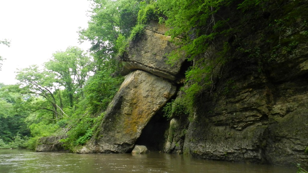
After that, the scene becomes a geologist’s dream. The 20’-wide creek wends around 40-80’ high bluffs, cliffs, crags and rock outcrops, some of which have been dubbed “Giant’s Tea Table,” “Castle Rock,” “Twin Sisters,” and “Devil’s Backbone.” In between the first and second miles you’ll happen upon a stunning wall of sheer rock like a palisade on the river-left. It’s hard to believe this is all basically in the backyards of farmhouses.
At this point you might notice small huffs of fog just above the water at the base of rock walls. These isolated breaths of fog are just that: cool air exhaled from openings within the rock, in other words, caves. There are countless caves in the first five miles, some of which are accessible by foot (not so much boat). On a hot and muggy summer day, these caves are godsends! Just remember to pack along a powerful headlamp and/or flashlight, not to mention clothes you don’t mind getting dirty. One cave in particular is worth an on-foot detour. It will be on your left about 10′ above the water roughly at the halfway point. Two large boulders provide an ad hoc docking spot to leave your boat in an eddy and a spot to climb and clamber into the cave. It’s definitely worth checking out! You can also see this cave in the Morrall video at the 2:30 point.
But it’s not all about gorgeous geology. There are tucked away forest settings and haunting oak trees, too. The juxtaposition had me ogling and wondering how this stream is not in the Ozarks.
The other characteristic that makes Carroll Creek such a gem is its swift current. With only very few exceptions, the creek is constantly riffly and just an absolute delight to paddle. Barry is spot-on about this trip not being suitable for beginners but it makes a smart “crossover” stream for those interested in upping the ante to whitewater light (except for that one Class II ledge in the beginning, that should be run only after some experience). There are several strainers and sweepers taking you into rock walls and nasty downed trees. Solid boat control is imperative. True, if you were to capsize, chances are that you will need only stand up and be fine, as the creek is always shallow. Still though, we recommend staying dry. It’s typically a clear stream, which makes the swift current even more exhilarating. But after all the storms and high water, the creek was muddy brown and adulterated. And now cue what we didn’t like…
Oh, also I picked up a spare paddle that was entangled in some flotsam in an eddy. Let us know if it’s your paddle, and we’ll gladly send it back to you. ‘Til then, it’ll be kept safe and dry in the Miles Paddled lost and found.
What we didn’t like:
Yes, the brown water was disappointing but I was consoled by at least being able to paddle the dang thing! Still though, I do feel a tiny bit cheated of the true Carroll Creek experience. Oh well. Leaving that jeremiad aside, I know I had a different adventure than Barry last year when he ran this or what you see in the Morrall video. This I believe has everything to do with the recent storms that raked through the area.
All in all, there were three troublesome trees that had fallen into the creek with nowhere to portage around on the banks. The first is found within the first mile. Too wide a tree to charge and slide/pull over and only one clear space to try to duck under but right at a spot with very swift current, thus making boat control and maneuvering quite tricky. It worked out for me but really it was a 50/50 shot of being able to grab onto it and yank aside successfully and quickly enough to then scoot my way underneath without being pinned to the tree or worse. I got lucky. In lower water this would likely not be an issue.
The second obstruction also involved going through some annoying branches and hoping it all kind of worked out on the other side but it was easier than the first. The third was just ridiculous: a huge tree hovering both sides of the banks, with a potential for ducking under on the far-right side but under a small rapid where the odds of being nastily swept, pinned, or capsizing are way too good to chance it. The only option (and trust me, this was a measure of last resort and necessity) was to hoist my boat a good four-feet into the tree, rest it on some limbs, climb up into and over the tree to the other side and pull my boat over and gently down. Your feet will be wet from the creek and the rest of your body will likely be pooled in sweat – now acting like a kind of glue for tree brush and the billion bugs I haven’t mentioned yet.
The only good thing about this portage is that it’s downstream from the Scenic Palisades Road bridge (where in retrospect I wish I had used as my take-out). Unless this tree is removed or “manicured” in such a way as to allow for safe passage for paddlers, I strongly recommend taking out at Scenic Palisades Road for two reasons: 1) there’s riprap on the upstream river-left side that allows for an un-muddy take-out and 2) by this time, you have paddled the best of Carroll Creek’s best. To continue to Jacobstown Road, the “official” take-out for this short trip, provides another 1.2 miles of paddling but it’s really nothing spectacular or memorable, if you ask me. True, a 6-mile trip is quite short for a destination paddle (especially as a non-whitewater river, especially for those of us driving from afar) so I certainly understand the appeal of adding another 1.2 miles. Just be prepared then for that nasty tree!
The other annoyance (and this really was a pain in the ass that distracted from the otherwise captivating creek) was the amount of bugs. They’re on you the minute you get out of your car and before the boat is off the roof. And they stick with you (often literally) the entire time to the take-out. The. Entire. Time. True, most were gnats and no-see-ums, not mosquitoes but sometimes I would prefer a bloodsucker I can slap to its splattered demise than to a kamikaze gnat dive-bombing for my friggin’ eyeball. Over and over, again and again. I felt like Pigpen from Peanuts with a swarm of bugs hovering around my head the whole time. No matter how regularly or aggressively I swatted them with my hat (full circles, slicing arcs, chops, punches, stabs, I could have been on the Kill Bill set) it was to no avail; they were imperturbable. You try to put up with it but it boils to a point where you just can’t take it anymore. I’m guessing this isn’t always the case, instead the byproduct of the recent rains and high water in summertime, etc., but pack bug spray and fumigate yourself like it’s going out of style!
The last thing not to like is the brevity of this creek. A 2-hr drive for a 6-mile paddle is romantic at best and impractical at worst, especially when there’s no gauge to guarantee water levels. Why not put-in upstream of Point Rock Park or take-out downstream of Jacobstown Road? Access, that’s why. Unless you know someone, or know someone who knows someone and that someone is a private landowner whose property conveniently abuts the creek, there are virtually no options. Seriously.
Upstream, the first bridge is only 2,000’ from Point Rock Park, at which you’d have to portage around the low-water bridge, so that’s silly. Upstream of that is Highway 78, which straddles a gorge and is totally inaccessible (unless you’re lowered by a helicopter). The next is Highway 52/64 where there is nowhere to leave a car and it’s unsafe and would be too prone to no trespassing issues.
As for continuing downstream, Carroll Creek flows into the Plum River a mile and a half after Jacobstown Road. However, there is not a single bridge after Jacobstown Road until Highway 52/64 (further west) by Old Mill Park in Savanna. That Carroll Creek/Plum River would be a 9-mile paddle in its own right and one reportedly miserable with logjams, downed trees and muddy portages. Thus, for all intents and purposes, Carroll Creek is just a 6-mile trip however you look at it (but it’s so pretty you’ll want to spend your time and dawdle, even get out and explore a cave or two. Or, frankly, just run twice – why not? It’s totally worth it.)
Unrelated to the creek, I camped one night at Palisades State Park, as Barry had last year. It’s a pretty park with cool hiking trails but the camping is a little lame. Most of the sites are packed like sardines and when I stayed there they were not selling firewood (there’s a mom-and-pop gas station about 2 miles down the road, in town, that sold soggy firewood in small $4.25 bundles. Had I known that, I’d have taken along my own from home, with or without emerald ash borers.)
A better campground choice, by far, is either Apple River Canyon State Park or Lake Le-Aqua-Na State Park, both in the area. I chose Palisades because it’s the closest to Carroll Creek and I didn’t want to drive back north only to go back south and then back north yet again on my way home. Plus, the road to Palisades takes you through the VFW halls, dive bars, Harleys and cheap kitsch in downtown Savanna. Per capita, I’m not sure if there are more biker bars anywhere in the state, maybe the time zone. One boasted being the “Key West of the Midwest.” If Jimmy Buffet with a couple Bud Lights is your ticket to fun, then you’ll be in hog heaven.
One more fun fact and accolade about Savanna: a former school there is now home to Facemakers, Inc, which boasts having “the world’s largest selection of mascot costumes.” Mascot costumes, the world’s largest selection, in Savanna, Illinois, so there you have it. Take that Moline!
If we did this trip again:
OK, so in a perfect world when that aforementioned tree is removed, I would take-out on the correct side of Jacobstown Road. I don’t know why but I assumed the take-out is right at the bridge (to my credit, or corroboration, a faintly trampled path could be discerned on the downstream river-right side, which is where I took out – it was very muddy). The correct take-out is somewhere on river-left about 50’ upstream of the bridge. In the high water it’s possible that I didn’t see this as a viable option…
Otherwise, this creek is definitely a must-do (and re-do), probably an annual event. Early spring is your best bet but I must say that I’m really glad I was able to paddle the creek in summer when all the foliage was raucously flush and verdant. Catching the creek with enough water then would be tricky and you might be forfeiting the clear/cerulean blue hue of the creek with all the runoff from heavy rain but so it goes on Goldilocks Creek.
***************
Related Information:
Camp: Apple River Canyon State Park
Camp: Lake Le-Aqua-Na State Natural Area
Camp: Mississippi Palisades State Park
Overview: Canoeing Adventures In Northern Illinois: Apple River To Zuma Creek
Video: Illinois Paddles
Video: Morrall River Films
Miles Paddled Video:
Photo Gallery:


Previous Trip Report:
April 26, 2013
☆ ☆ ☆ ☆ ☆
Take the stunning cliffs and curves of the Kickapoo River, the clear water and swiftness of Badfish Creek, the length, riffles and intimacy of Robinson Creek and you’ve got the best of all paddles, Carroll Creek.
Gauge: n/a
Time: Put in at 2:15p. Out at 4:30p.
Total Time: 2h 15m
Wildlife: Five whitetail deer, one beaver, a muskrat, two heron, hawks, geese, roosters, swans and ducks.
Last year was meant to be a year of Northern Illinois paddles, with Carroll Creek being at the top of the list. In fact, it’s been on my must-paddle list since the moment I started paddling. However, with historic drought conditions, Southern Wisconsin was suffering (and Illinois was obviously worse) so we had to head north for most of our trips.
But this year, I made it a point to plan a trip there early in the season and I’m glad to say I finally made my way to the much-loved but often-unpaddable, (due to low water) Carroll Creek which starts in Mt. Carroll, Illinois. Neither of the other Miles Paddled guys (or girls) could make the trip (nor could Timothy, who was totally bummed – he had prior obligations. Sorry man, I hate to break it to you but it was as spectacular as you’ve heard but I know you’ll make it there).
What we liked:
From the moment I saw this video by Tom Lindblade in one of his Illinois Paddles videos, I knew I had to experience this creek. Then more recently, Morrall River Films documented a trip down the Carroll, only making my need to paddle it greater (which by the way, we highly reco all their films. They’re a must-add paddling resource for your library).
Mark says “The Carroll Creek is probably one of the nicest streams I’ve ever paddled. From its towering fern-covered limestone cliffs, to its narrow intimate size and fast challenging current. It’s everything I enjoy in a stream.” It’s a spot on description and I couldn’t agree more. It’s all that, (possibly even more?) and exactly what I’ve been searching for in a river or creek too.
Coincidentally, Mark extended an invitation to join their group who paddled the creek the previous Sunday. Other commitments prevented me from making it so I had to (begrudgingly) turn the offer down and keep to my original plan.
As mentioned, the reoccurring and unfortunate theme to Carroll Creek, also known locally as the Wakarusa (an Indian name meaning “Winding River”) is that it rarely has enough water in it to canoe or kayak. While the water supply is constant on the creek, it’s not always runnable due to the small watershed and it drains quickly (unless that’s something the locals say to keep this prime secret to themselves – but I doubt it). Despite the current flood conditions across the midwest and especially our area (and as evidenced by every creek and river I passed on my way down), the Carroll is an anomaly. It’s as if it’s flood-resistance (well I’m probably stretching that truth, apparently it does). You really have to try to hit this up in Spring or after heavy rainfall.
As warned, I expected to have difficulty in the shallows with the creek already losing water but I didn’t have any trouble. The water was at a perfect level for my trip (I was fortunate for a midweek rain) but if it were much lower, I would reconsider since it’s easy to see how another inch lower and I would’ve been dragging my kayak in more than a few places. Since there is no gauge, you have to use the low-water concrete bridge near the entrance to Point Rock Park which extends over the creek.
The put-in at the park (which is quite nice in its own right) is very convenient, offering multiple access points. You can put in at that concrete bridge or any numerous areas along the creek from the wide-open grassy field.
Once on the creek and only after the first left-bend in the creek, you’ll already come to the only Class II drop on the creek. I chose to portage around it since I totally forgot about it and didn’t have my spray skirt on or even in the kayak. I would’ve most definitely taken on water judging by the chute available. Next time, I’ll run it with abandon (famous last words).
Following that drop and just around the bend was an ominous sign – a headstone laying in the water (perhaps a sign that I made the right choice in not running that drop?). Also on that same stretch, keep your eye out for frisbee golf discs from the park’s course on the cliff high above river-right. I spotted a couple and even landed a driver which must have been an incredibly errant throw. It should be noted that there are other strange things to be spotted on your journey aside from the headstone, like chairs, precariously-positioned picnic tables and a surprising amount of litter in the water.
From then on, you’ve entered a steep canyon with beautiful undercut rock formations and bluffs ranging from 50-75 feet high. And it’s riffly stretch after riffly stretch. That’s what I love about the Carroll. It seems as though you never travel more than a couple hundred yards before you are greeted by riffles, ledges and/or breathtaking rock cliffs and caves. It’s gorgeous and intimate. Incredibly pretty.
Before the Ivy Road bridge you’ll spot a beautiful house on river-right (something to be envious of for sure) and you’ll hit a series of 1/2 foot naturally formed ledges (easy for sure). Almost immediately after that bridge is the Scenic Palisades Road bridge. From there until the take-out, the creek is less twisty but not less exciting. It’s still riffly, with some really nice back-and-forth paths, and the current just grabs your boat and takes you along for the ride.
The take-out is river-left just before the Jacobstown Road bridge. It’s undeveloped but decent for a bridge-side take out. On this day, it was a rather unstable slab of wet sand and I sunk down ankle deep but nothing to complain about.
This creek is not for beginners or the casual paddler but it would be a great primer-paddle for someone interested in taking that next step towards whitewater with its drops, ledges, riffles, windy nature and pushy current that sweeps your boat around tight turns and near walls and strainers. Only once did I have to portage (other than that Class II) due to a recently-fallen tree. It was at this point that I noticed just how chilly the water was. Portaging in general is quite easy on this creek though, if you feel the need to avoid potential tricky situations. It’s clear and stony in the shallows and the deeper channel of water for which to follow is a beautiful cerulean color.
There is plenty of wildlife on the paddle too. I came upon two whitetail deer drinking from the creek, a muskrat, hawks, two heron, a million geese (some whom were obviously protecting nests so I kept my distance) and a bunch of roosters, swans and ducks who were co-habitating on some guys lawn near the take-out. I also maneuvered around a very waterlogged carcass of what appeared to be a deer at first glance but judging by the leg of the animal, it might have a been a dog.
There are several caves along the dells of the Carroll too. I didn’t explore these former lead-mines but will surely check them out on a return visit.
The creek eventually flows into Plum Creek a few miles south of the take-out. It might be worth checking out the lower few miles on a future paddle.
I camped at Mississippi Palisades State Park on a tip from Timothy. It was an interesting State Park, not a lot of privacy. In fact, every Boy Scout Troop in Illinois happened to be camping there this weekend. Must have been a Jamboree or something. I found a site in the far reaches of the park. The ground was incredibly soft and waterlogged, as if you could dig down and find the Missisissippi moving below. At night, the trickle of water could be heard underneath the leaves coming down the hill. The next morning I had to put the Jeep in 4-wheel drive to get out since it had sunk overnight.
Being the first time I ever camped (and paddled) in Illiniois, two things really shocked me about Illinois State Parks. First, they don’t require a State Park sticker. Hooray! Second, (and the real shocker) was the “All Alchohol Prohibited” sign upon my entrance to the park. Let me tell you, being from Wisconsin, where no such thing occurs, it was like seeing unicorn. It just doesn’t exist. In fact, as I was taking picture of the sign, a park ranger came over and without even a question he said “yeah, it’s just one of those State things” and then smiled and said, “I recommend a Red Solo cup.”
This is where this paddling trip report really ends because from here on out, it turned into a brewery trip…
A radio station I randomly happened upon was playing tribute to the late George Jones which set the mood for my drive alongside the swollen Mississippi and through the small river towns like Savannah. It made for a great drive and I found myself compelled to travel North on the route home through the beautiful city of Galena. Coincidentally, the Boy Scouts were canvassing the Galena area too. They had President Grant’s home on the hill surrounded.
Then, since I was more or less in the area, I headed up to Potosi to have a beer at the brewery (something I had failed to do on our Grant and Galena trips). The brewery is beautiful. From a design perspective, the details and branding are spot on and the beer is fantastic. In my opinion, they put out some of the best beer in the State (except for maybe Central Waters, of course). Insider tip: If you purchase a pint glass in the gift shop, they reward you with a free beer token. I only found this out afterward, so I’m saving it for the next time.
On my way back East towards Madison, I decided to keep with the theme of the day and detoured down to New Glarus. For living in Madison for over a decade and enjoying my fair share of Staghorn and Moon Man, I had never visited the brewery. The vibe was a little different and very crowded due to the (finally) seasonable weather. The brewery is expanding again so things are slightly out-of-sorts but it was well worth the visit. Six bucks bought me a full pilsner pint glass and a taster (half a pint) as well as a coupon for a free beer at one of the local New Glarus bars.
A paddling trip just doesn’t end any better than that. Sometimes it’s the drive and sometimes it’s those last minute diversions that tie the whole trip in a bow.
What we didn’t like:
I’ve had some excellent solo paddling trips and they can really be great experiences but on a stream as beautiful and exciting as Carroll Creek, experiencing it alone isn’t enough. You really want to share something this awesome. The rest of the crew needs to experience this paddle (and I’ll be happy to join them anytime they want to).
Also, no alcohol permitted in a State Park? Is that even American? Camping and beer go together like… [insert two awesome things].
If we did this trip again:
If there ever was a “perfect creek”, the Carroll Creek would be it. It’s intimate and exciting. It’s a narrow creek and offers countless riffles, drops and ledges and it’s a breathtaking paddle through a canyon filled with gorgeous bluffs and wildlife all around.
This is the kind of paddle you should plan for every year. Put it on the calendar for early April, bring some friends and have a great day trip. The two-hour drive from Madison is well worth it. It’s such a rarity to paddle it, and that alone justifies the travel. It’s a special creek and one that I hope to visit often.
Photo Gallery:


No Comments