County Road W to Highway 47:
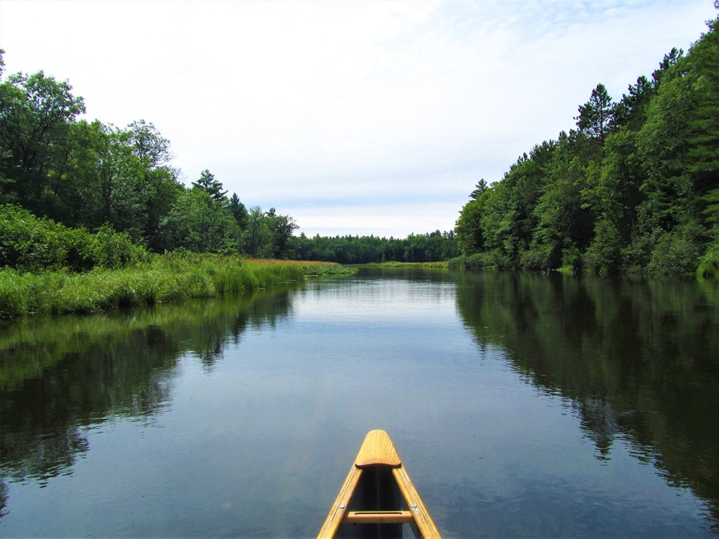
A quintessential northwoods narrative known not for its rapids or granite boulders, but rather its soft features and easy float, this classic paddle on the Manitowish River is a natural delight for slow-flow enthusiasts who wish to soak in a mostly undeveloped landscape alternating between hardwood forest and squishy marsh with a generous array of wildlife opportunities all along the way. Added perks are the ample boat-only campsites, multiple access points to tailor this trip, as well as an awesome trail to bike-shuttle from take-out to put-in.
Rating: ☆ ☆ ☆ ☆
Trip Report Date: August 6, 2022
Skill Level: Beginner
Class Difficulty: Riffles (w/one brief stretch of Class I rapids)
Gradient:
~1′ per mile
Gauge Recorded on this Trip:
n/a
Recommended Levels:
Water levels are usually reliable for this trip.
Put-In:
County Road W, Manitowish Waters, Wisconsin
GPS: 46.13872, -89.88768
Take-Out:
Highway 47, Manitowish, Wisconsin
GPS: 46.13082, -90.01197
Time: Put in at 11:30a. Out at 4:15p.
Total Time: 4h 45m
Miles Paddled: 10
Wildlife:
Bald eagles, turtles, beaver, deer, mergansers, wood ducks, blue teals, kingfishers, some large fish fringed in red (redhorse?), crawfish and mussels.
Shuttle Information:
By bike it’s 7 miles all along a dedicated trail – which is totally free, flat, paved, and very pretty! By vehicle it’s pretty much the same distance, since the two are largely parallel – but nowhere near as fun.
Background:
This section of the Manitowish River was first featured in Milespaddled.com’s Canoe and Kayak Camping Wisconsin Water Trail Guide.
A quiet guiding spirit of the northwoods, the Manitowish River drains High Lake in Vilas County near the U.P. border and then gently meanders westward for some 40+ miles connecting a nexus of lakes along the way like a bejeweled necklace before making a precipitous slip to the south where, after being fed by the Bear River (re: don’t feed the bear) from the east, the two streams inexplicably become – abracadabra! – the North Fork of the Flambeau River just before the ginormous sprawl of the Turtle-Flambeau Flowage to the west (aka Wisconsin’s version of Sylvania – aka poor man’s Boundary Waters). While there are small towns and communities along the way (people do love to live along lakes), the whole river complex is surrounded by the Northern Highlands-American Legion State Forest. Fun fact: the NHAL is the largest swath of public land in Wisconsin, comprising more than a quarter-million acres. What does a quarter-million acres look like, you wonder? Bigger than all of New York City.
If you’ve driven up to Mercer (or past Mercer up to Haywood or Ashland), then chances are pretty good to indisputable that you’ve been over the Manitowish River. I have – and have long been curious about it. Abetting that curiosity are two unrelated nuggets:
~ It’s the single favorite stream of a dear friend of mine who no longer lives in Wisconsin but had a family cabin nearby in Iron County; and
~ Over winter I read an admirable book entirely dedicated to the Manitowish called River Life: the Natural and Cultural History of a Northern River, written by John Bates (one of the annual presenters at Canoecopia – and always one of the most engaging). I cannot convey how much I deeply admire paeans to specific places; their love of a certain area – good and bad, for richer or poorer, in sickness and in health – is powerfully palpable.
But the Manitowish is given its due also in the Wisconsin Trail Guide as well as Mike Svob’s Paddling Northern Wisconsin (both excellent resources for this trip and so many others). It’s worth noting that neither describes the 20-odd miles of river from its source at High Lake down to Rest Lake in the town of Manitowish Waters, where it is dammed for the last time. Our trip likewise begins on the downstream side of the dam.
Overview:
There’s a public boat launch located on the downstream side of the County Highway W bridge, river-left, accessible via the parking lot for the Pea Patch bar and motel, where you’ll see picnic tables. While shallow in sections, the river is deep enough for motorboats to use as a launch due to its proximity to Vance Lake only a hundred yards downstream. You’ll see the ghostly vestiges of several dozen pylons just above the water’s surface, harbingers of an old fish hatchery that was first built by the Civilian Conservation Corps in the early 1930s, primarily for muskie and walleye. Here as in most stretches of the Manitowish, the current is slackadaisical (can we make that a term from now on?). The banks will widen, and before you know it, you’re in Vance Lake (aka Just Don’t Vance). Dotted here and there along the tall banks of the lake are attractive houses, but the overall feel is not one of congestion. If the lake were a clock, the outlet for the river would be at ‘8’. To the right of it is a very primitive campsite – even more rustic than the others downriver… and possibly a holdover from a bygone day? (Its inconspicuous sign is labeled “V1” – ‘V’ for Vance? – and is designed with a font and pattern not used since the 1960s.) Why the DNR would have a campsite here, with little privacy of its own and at the mercy of nearby landowners, let alone so close to the dam, is a curious one to ponder while later gazing at stars. But there is a large and sharply incised boulder immediately in front of the shoreline at this spot. Author and local historian John Bates tells of a similar monolith on the north shore of the lake being “reminiscent of spirit stones that the Ojibwa singled out as places to pray.” So maybe that’s why the campsite is where it is…
No matter; we’re back on the sluggish river in the easy back and forth between lakes. The surroundings here are soft and pretty, with marsh-grass and lush flowers lining the banks. Sturgeon Lake comes into focus, another spongy sprawl. I’m not sure what kind of ink-blot image one can render of the lake’s shoreline, but the outlet is once again found in the southwest. If/when in doubt about directions, just listen for the road and follow it. Incidentally, the lake was not named on a mere whim. The Manitowish River is a spawning habitat for sturgeon. Whether you see one of these ancient denizens or not, it’s mighty cool to know that they’re there… somewhere beneath your boat.
The most exciting (relatively speaking) and one of the most aesthetic sections in this trip follows with a meander here and there towards the first bridge – the only one until the takeout. The road here is Highway 51 (aka Stoughton Road for us southerners). Immediately downstream on river-left is a convenient access – and is where both Svob and WTG begin their make-a-wish trips. The only truly moving water follows in a riffle-rifled stretch a hundred yards long over a rocky streambed with a bevy of boulders to dodge and beneath a spanning pedestrian/bicycle bridge that is part of the Heart of Vilas County trail. If the river is low, this will be Scrape City. But with enough flow it’s an enjoyable little run of riffles and at best Class I rapids. A painter’s palette of deciduous and conifers together with marsh flowers and water lilies make this a very pretty sweep, and the paddling here exemplifies that classic northwoods experience – clear water even on a cloudy day gurgling over a streambed abounded by rocks, with maybe some mergansers bobbing along, all surrounded by vegetated banks lined by cedars and steep evergreens – found only in vestiges down in southern Wisconsin.
At a sharp bend to the left there’s a curious access on the right. I say “curious” because it’s not on any map and I’m not entirely sure how you get there from a road (via Benson Lake Road, presumably). But it’s not a campsite; it’s indisputably a put-in/take-out. If you have only an hour to paddle, end here. A short straightaway leads into kidney bean-shaped Benson Lake, a pleasant enough little pond with a couple of attractive cabins and houses. Keep to the right shore to follow the river. You’ll basically horseshoe back up (not a verb, I know, but why not?). A few more houses and whatnot lie along the river’s edge here – and who can blame them? All told, it’s a brief affair, after which there will be precious little development at least within eyesight (the sound of the often parallel road is another story).
From here to the next access the surroundings are supremely pretty. Admittedly, there’s nothing spectacularly dramatic – no waterfalls or ledges or huge boulders; that’s just not the Manitowish. Instead, it’s a soothing mix of white and red pines with willows and cedars, lush lily pads and submerged logs supporting nursery sprouts of grasses and plants. Call it a serene scene on a slow pace that’s all go with the flow, allowing you to soak it all in.
The next and more intuitive access is at the Circle Lily Creek Landing along the banks of the River’s Edge Lodge & Outfitters, a rather impressive enterprise replete with boat and bike rentals, XC skis and snowshoes for the winter, campsites and even an indoor decadence option a la “Fall asleep in the loft to the sound of nothing but your dog’s snoring (yes, of course, we’re dog-friendly),” which how in the world could I not give a shout (snout?) out to? Or just hang out and chill, get a beverage, stretch your legs, and indulge in lawn games. It’s a one-stop hop and out on the trail, if you take out here – roughly 4 miles down from the put-in.
Another straightaway from here shoots due south before swinging to the west (right). At the bend lies the next designated DNR campsite, a true beauty on the right (they’re all on the right) marked with a sign emblazoned “MR 51.” (MR, one can surmise as Manitowish River; 51 though? The next site is MR 52, lest one correlate the highway name and number.) When it comes to paddle-camping, this is pretty much glamping at its best, baby! It’s got a picnic table and fire ring – and it’s 100% free. And you’re near nobody but the splendid presence of protective pine trees towering above you. Eat that, Boundary Waters! Suck it, Lower Wisco! (I’m kidding, of course – but these sites along the Manitowish River are sublime.)
I would be remiss to not mention that due west of the River’s Edge place and just a smidge downriver from the campsite is the former footprint of Camp Mercer, a CCC operation that began, like the aforementioned fish hatchery, in the 1930s. (To be sure, a paddling blog is not the place or time to hold forth about the commendable CCC or tacitly assert anything about hard times and the role of government to the people or the sense of civic duty to one’s country. But boy oh boy, are we a whole long way from those days, 90 years later! It’s simply unimaginable anymore that Uncle Sam would just pay young people to plant trees, build bridges, blaze trails – all for the Public Good no less. Put down that smartphone and pick up that backhoe! Snide cynicism aside, here are some cool black and white photos from the era. And for more info on the camp and the CCC’s impact on Wisconsin’s northwoods, here is a well made video.)
A series of lush meanders leads south and away from Highway 51 for the next couple miles, the surroundings splendidly undeveloped and ranging from the squishy squelch of marshy grass and bogs to needle-softened blanket of wooded banks. Another campsite lies 1.5 miles down from the other. The next landing/access – and last until the take-out – comes up at what’s called “Highway 51 Wayside Landing,” entirely inspired by no known poetry or feat of imagination, but at least tells it like it is. Generally speaking, a lot of folks (re: not paddlers’ paddlers) end their trips here A) for the sake of convenience and B) to skip the next 3.5 miles of meandering. That’s all good in the hood – and no judgment here. But it’s this next section – at least for this trip on the Manitowish – where the river is at its wildest and most undeveloped. Just saying…
That said, it is marshy meandering through beaver dams, wavy grass, reeds, and a whole lot of off-shoot sloughs. Arguably not for everyone. But for the avid paddler, that sounds like a dream come true. About midway between the last landing and the take-out is yet another campsite (for those keeping score at home, that’s MR 53). Eventually the river makes an earnest break for the northwest closer to Highway 51 again, and the sound of the road will corroborate that orientation. Before you reach the road bridge you’ll pass under a wooden bridge (today for ATVs and snowmobiles) with a sign that reads “End of Trip Hawk’s Nest,” signaling that it’s the next bridge where paddlers will want to take out. Nota bene: “Hawk’s Nest” was the name of the outfitter prior to River’s Edge Lodge & Outfitters. For those of us who dig history and archives, I for one revel in the past-recreational semiotics of this sign.
The road bridge at Highway 47 comes immediately afterward, and the access off the river is, like everything on this trip, on the right, downstream side. It’s not developed, but it’s totally doable and obvious, with little more than a short schlep from river to road.
What we liked:
The Manitowish is a sweet stream whose gentle nature, charm, and unimposing prettiness are impossible not to make a favorable impression. The wildlife opportunities are superb and, generally speaking, the surrounding environs are wild and undeveloped. There’s a tremendous amount of history along the banks of the slow-going current, both Ojibwe and European.
There’s something about a river-lake-river trip that feels special. Maybe it’s that it requires a modicum of navigation to find the outlets. Maybe it’s the sense of getting the best of both worlds – flat-water lake paddling and moving-current river. Either way it’s a unique experience, all the more natural and enjoyable when there’s no dam(n) interrupting your way.
While it added only a skimpy 1.5 miles, I’m really glad that we began at County W, and not at Highway 51 as recommended in the other guides. Of course, it extends the stay. But more than that, it got me thinking about our relationship to land, whether we’re passing-thru or stewards-of. Perhaps more so than other woodsy swaths of Wisconsin, the tri-county area of Iron-Vilas-Oneida palpably captures that northwoods ethos evoked by the hallmarks of ritualized pastime that have been reenacted for generations: gasoline stirring the whir of outboard engines; Supper Clubs’ fried fish, prime rib, and raucous laughter clinked with tumblers of Old Fashioned and bottles of cold-lager Leinie’s; tonight’s smoke from fire rings and burning wood found tomorrow on clotheslines strung between cottages drying out the day’s bathing suits. All of these hallowed memories, fused by scent, sight, and sound, radiating outward like tree rings, like ripples from skipped rocks. (It’s not for nothing that these three counties contain one of the largest densities of lakes anywhere in the world.) But maybe all that’s nothing more than marketing, a “come to the cabin” ad campaign for us flatlanders down south and city folks suffocating from offices. Maybe today, in the wake of the pandemic but still in the flood of divisive politics and tribalism, up north is mired in up yours. Maybe it always has been; now, there’s just more of us – and caffeinated by social media.
But those arel human machinations, after all. What supersedes all that BS are the sweet scent of pine trees hand in hand with sandy soil and soft-grass marsh along the lake’s edge; the vaunted fauna of bald eagle wings swooning the sky and loons’ cries eerily echoing the ethereal, all while weightless deer and lumbering bears browse and graze upon terra firma.
Author John Bates writes eloquently about reading a landscape while out and about, and how, once done successfully, “the landscape acquires a sense of place that becomes part of the reader’s soul, a center point around which one’s life revolves. This sense of place grows incrementally by living with the land over time.” By and by, we’re all just passing through. It’s a question of duration… Those young fellows in the CCC, living in barracks on the banks of the river, did they have the luxury of learning how to read the landscape? Or were they too tasked to change it? People die, empires crumble – feint outlines of a foundation are all that remain. But the Manitowish captures the essential and the acquisitioned, the sense of how it was (all along) and how it’s been (since the 20th Century and the advent of tourism). Maybe that’s why that campsite on Vance Lake persists, its spirit boulder spearheading the entrance.
Finally, there’s the bike shuttle option. We love a dedicated bike trail – who doesn’t? – the more so when it’s a perfectly viable conduit between take-out and put-in. When I first compiled a long list of places in the state to combine paddling and pedaling, and then presented a personal “best of” at Canoecopia earlier in the year, the Manitowish and the Heart of Vilas County Trail were at the top (and not only because it’s the northern-most combo in Wisconsin). To be clear, since most of this trip is in Iron County, west of Vilas County, the trail portion is an adjunct to allow bicyclists safe logistics to get to Mercer and is not a part of the trail proper. Indeed, the majority of the shuttle for this trip is on a residential road that runs parallel to Highway 51. It’s really not until you pass River’s Edge, on your way to County W, that the bike trail is supremely pretty.
What we didn’t like:
The only caveat to the aforementioned river-lake-river allure is that lakes typically come with development, and the fabled northwoods is no exception to that maxim. Fortunately, the shoreline development along this trip is limited both in sections (found only in the first half), aesthetics (all cabins and lake houses, no McMansions), and in numbers (there aren’t many, period). The second half of this trip is entirely undeveloped.
The only other matter worth mentioning is the proximity of Highway 51, which runs parallel to the river for the majority of the trip. It’s not necessarily distracting (or detracting) in the same way that some roads can be when paddling rivers, and, by and by, there are only a couple times when the two are truly in unison. But I feel obliged to mention it.
If we did this trip again:
This is a delightful gem of a trip that we’ll be sure to do again. The only thing we’d do different is plan to camp overnight at one of the many dedicated sites and extend the experience the following day down to Murray’s Landing – the only access point after Highway 47 and the last one before the ginormous sprawl of the Turtle Flowage. Both Svob and the WTG allude to a mist that hovers above the river early in the morning and consider if that is how the stream’s name derived – “Manitou” meaning spirit in Ojibwe. (Shout out to my first-ever kayak, a Necky Manitou 13’ made of composite materials and as black in color as Johnny Cash’s wardrobe – still miss that bad-ass boat…) It would be something special indeed to see a beguiling fog lingering above the whimsied meanders of the lower Manitowish like a silky scarf around its svelte neck, which would require already camping along its banks the night before too witness such reverent elegance come sunrise.
***************
Related Information:
Canoe + Kayak Camping Wisconsin Water Trail Guide: Manitowish River
Camp: Sandy Beach Lake Campground
Guide: Wisconsin Trail Guide
Outfitter: River’s Edge Lodge and Outfitters
Wikipedia: Manitowish River
Photo Gallery:


1 Comment
Jonathan Beers
July 16, 2023 at 11:20 amTimothy wrote: “If you’ve driven up to Mercer (or past Mercer up to Haywood or Ashland),” You probably meant Hayward, not Haywood? Thanks for the report. We’re going on a Natural Resources Foundation of Wis. (snorkel-optional) paddling field trip to look for mussels on the Manitowish. We’ve done NRF field trips on the Mukwonago and Wolf in the past: https://wiatri.net/inventory/mussels/news/pdf/2019Winter_ClamChronicle.pdf
“Five field trips allowed participants to explore waters in-search for unique populations of mussels in the Chippewa, Manitowish, Mukwonago, and Wolf Rivers.”