County Road A to Lily:
A mostly fun and pretty trip on what can be described as the dress rehearsal of the famed Wolf River rapids further downstream, this stretch is mostly quietwater with a couple notable exceptions. Just make sure you paddle this when the water is high enough, otherwise it’ll be frustrating.
Rating: ☆ ☆ ☆ ☆
Trip Report Date: September 5, 2015
Skill Level: Expert
Class Difficulty: Class I-II
Gradient:
6′ per mile (on average but it’s a lot higher in the Class II section)
Gauge Recorded on this Trip:
Langlade: ht/ft: 7.8 | cfs: 280
Recommended Levels:
This is below our recommended level. To avoid scraping, we strongly recommend at least another couple inches on the gauge – ideally over 8’ and with a flow rate above 300 cfs.
Put-In:
County Road A, south of Pearson, Wisconsin
GPS: 45.34899, -88.99474
Take-Out:
Highway 52, Lily, Wisconsin
GPS: 45.30765, -88.85806
Time: Put in at 1:20p. Out at 6:20p.
Total Time: 5h 0m
Miles Paddled: 11
Wildlife:
Osprey, swans, bald eagle, unidentified fish and great blue herons.
Shuttle Information:
9.4 miles (bikable, but not great).
Background:
The conventional put-in for this section of the Wolf is two miles upstream, in Pearson, at County Road T. We chose to put in at County Road A instead because our group of six was running late as it was, coming from Madison three hours away and we were also meeting two friends of ours who’d started before us.
This turned out to be a comical debacle, as the most difficult rapids of the Pearson-to-Lily section, called Wendigo Rapids, a Class II due to the studded boulder gardens, begin right here at the County Road A bridge and continue for about 500 yards – and of the eight total paddlers, six of us all capsized one way or another in this segment. Of those six, four of them had been on the water for about five minutes before getting sunk! Talk about baptism by rapids.
But it turns out, we were not alone. In Rick Kark’s recently uncovered resource, “Kark’s Canoeing and Kayaking Guide to 309 Wisconsin”, he apparently had a similar experience on this stretch, “I have never paddled the two miles from County T to County A. I paddled the section from County A to Lily in May 1998. Immediately I encountered Class II Wendigo Rapids which ordinarily would be easy for me. But the rock garden was so shallow it gave me problems. I was in my non-whitewater Wildfire canoe which is harder to turn. It got caught sideways between two rocks and flipped.”
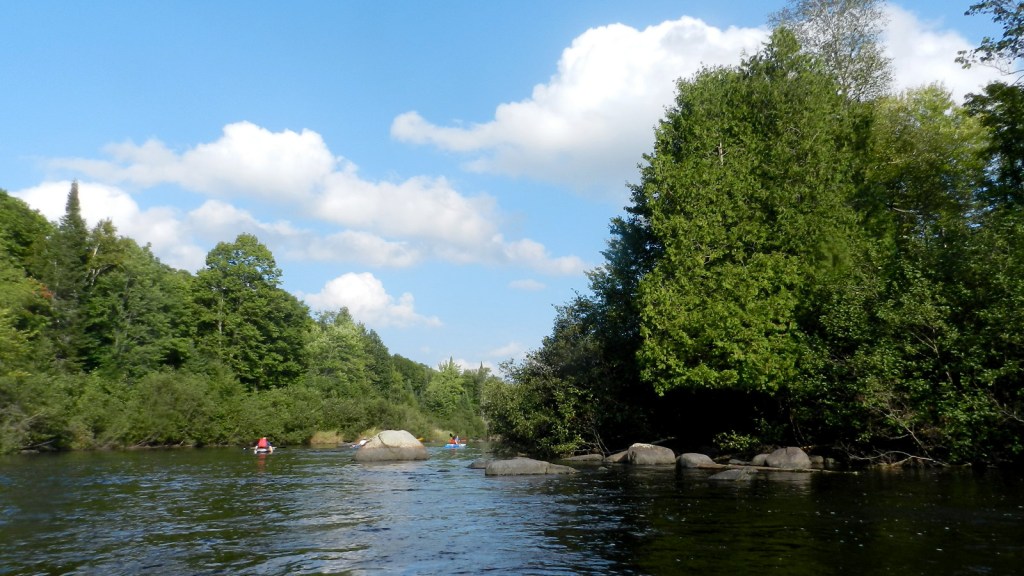
After Wendigo Rapids, the river calms down, slows down and often flows in long straight strokes for 6.5 miles. There’s about a half-mile of intermittent Class I and I+ rapids that resume where the river constricts and bends, as well as an alternate landing on your left. A couple more delightful but brief Class I rapids await shortly after the alternate landing. Alas, this is then followed by 3.5 miles of additional wide quietwater all the way to the take-out.
There’s not much to write home about the topography on this trip, as there are few hills to speak of. There is a pleasant mix of trees and of course a gazillion boulders. The take-out is on the downstream side of an attractive retro truss bridge on the right. It’s a common access point for the popular next-section of the Wolf but it does require you to carry (or drag) your boat a hundred yards or so to the parking lot.
What we liked:
For most of us, this was our first time on the almost mythic Wolf River (true, we were not on the truly turbulent rapids for which the river is renowned; still though, there’s at least a teething wolf pup feel).
Seeing the river and its rapids at our compromise put-in made me giddy. By one of those coincidences that seems too good to be true (until it actually works out that way) our two friends happened to meet us at County Road A within 10 minutes of our arrival. It was great to spend the time together with the whole group from that point forward, even if most of us would encounter a couple humbling moments in the river, not just on it, only moments later (fortunately, it was one of those stupid-hot September days, so the water was refreshing).
More fortuitous still, the last of our party – two more from Madison who couldn’t leave town until much later – pulled into the take-out within five minutes of us reaching it (considering that it’s a three-hour drive and that we paddlers had no idea when they would be even leaving town and they had no real idea when we’d be arriving at the takeout, this was rather extraordinary timing).
It was the end of a longish day on the river, the late afternoon sun was golden and the first of two nights camping in the Nicolet National Forest was about to begin!
What we didn’t like:
First and foremost, the water was way too low. While still runnable, the scraping was frequent and frustrating. Worse still, when it’s this shallow you’ll hit umpteen barely emerged or just barely submerged boulders that when run into will A) startle you and you’ll probably lose your balance and tip or B) suddenly turn you sideways and within seconds gallons of water will start spilling inside your boat (and possibly/probably cause you to tip due to the imbalanced weight). Two of the paddlers in our group whose boats took on an almost literal ton of water had their entire shins scraped raw when trying to get out of their boats after they had filled up in order to empty the water. Not fun.
The otherwise awesome Wisconsin Trail Guide states that the lowest recommended height of the gauge should be 7.6’. I find this a little bit ludicrous, frankly, because it was frustrating and even unsafe at 7.8’. Turns out, this level is basically arbitrary. Where does the measurement of 7.6’ come from? The gauge itself. What I mean is, the lowest the gauge even records is 7.6’. So saying that 7.6’ is the lowest recommended level is misleading: it’s not the lowest recommended level; it’s literally the lowest the gauge itself reads. Trust me and many other paddlers on this: 7.6’ itself is too low; the true lowest recommended level should be at least 8 feet at the gauge.
This whole question of safety in higher water might sound counterintuitive. Let me explain: I am not saying paddle rivers with rapids only when they’re raging high – for that’s too much a pendulum swing in the opposite direction (unless of course you’re a skilled whitewater paddler who seeks only raging levels). What I am saying is oftentimes more water allows you extra “cush” over rocks and hard spots that will otherwise damage your boat potentially or cause you to capsize in a way that higher water wouldn’t. The clarity of the water might be compromised, but you have to ask yourself this question: are you paddling a river with known rapids to look at rocks underneath the water, or to be paddling the rapids themselves? Personally, I’d rather paddle liquid mud that’s high and rolling with waves than a crystal clear stream where I’m scraping the whole time.
The other dislike is the monotonous in-between portions of this trip where there are no rapids – which, in this stretch, are most of the trip. The landscape is certainly pretty but by no means spectacular. There’s a general lack of development along the banks, as much of the land is state-owned but there are some private houses and cabins here and there – more than what I’d expect for a river that is one of only two in Wisconsin that earns the much coveted designation of a National Wild and Scenic River (the other being the Upper St. Croix River).
There are a lot of wide-open marshy sections, which are fine but not what I associate with the Wolf or want to drive several hours to experience (this gets much better in the trip segments further downstream). Also, for what it’s worth, only 24 miles of the entire 225 miles of the Wolf River, or essentially 10 percent, is federally designated as “wild and scenic” and it’s all enclosed within the Menomonee Reservation, in which you will need to purchase a permit in order to paddle.
If we did this trip again:
Being hopeless river completers, at some point we’ll put in at Pearson, or maybe even upstream and then run the Wendigo Rapids again – though only in higher water! But there’s little incentive to revisit the rest of this trip. It was pleasant and I’m glad we did it but it wasn’t interesting enough to inspire a repeat. Besides, there’s just so much more interesting sections of the Wolf not yet paddled!
***************
Related Information:
Wolf River I: Lily to Hollister
Wolf River II: Hollister to Langlade
Wolf River III: Langlade to Markton
General: American Whitewater
Guide: Paddling Northern Wisconsin
Guide: Wisconsin Trail Guide
Outfitter: Bear Paw Resort
Wikipedia: Wolf River
Photo Gallery:


1 Comment
Timothy Bauer
May 22, 2023 at 6:31 amRevisited this splendid section yesterday during radically higher water levels than when this trip was firstreported — 625 cfs vs 280 cfs. World of difference! Wendigo Rapids were a wild ride, nearly half a mile long of solid Class II boulder gardens and haystacks. It was still an obstacle course of hazards to avoid, just-miss, or not-see-til-the-last-second-and get-stuck-on (or pinned against), but it was howling good fun like the rowdier sections of the Wolf found further downstream.
A couple considerations…
The access at County T is quiet and easy, but was full of ticks on this late-May afternoon. The little bastards were crawling even on temperature-neutral gear, not just warmth-emanating skin. All wood ticks, but still. And our designated take-out at the super-quaint Military Park park access was pretty pesky with mosquitoes (though not as bad as the full-on Red Cross marauder endured along the banks below Wendigo Rapids when emptying one of our boats of a whole lot of taken-on water). Both bug-ridden accesses could be the byproduct of circumstances or timing, but Caveat Paddler.
And the 2-mile segment of County T to County A is all quietwater with a northwoods feel. Not as flat as the marsh/slough section that predominates Wendigo Rapids to Lily, but still pretty slow-going.