Cameron Crossing Bridge to Au Train Heritage Landing
A truly splendiferous (and serendipitous) paddle through the outskirts of the Hiawatha National Forest between Marquette and Munising in the north-central nub of Michigan’s Upper Peninsula, this trip features extraordinary clear water, a protected forested setting, excellent accesses, one of the best and uniquely short shuttles, and the unforgettable experience of finishing into Lake Superior – all in under eight miles.
Rating: ☆ ☆ ☆ ☆
Trip Report Date: June 8, 2023
Skill Level: Beginner
Class Difficulty: Flatwater
Gradient:
~2′ per mile
Gauge Recorded on this Trip:
Au Train River at Forest Lake: ht/ft: 3.7 | cfs: 150
Recommended Levels:
We strongly recommend these levels. That said, water levels are usually reliable.
Put-In:
Cameron Crossing Bridge on Au Train Forest Lake Road, Au Train, Michigan
GPS: 46.41297, -86.84254
Take-Out:
Au Train Heritage Landing also on Au Train Forest Lake Road
GPS: 46.4329, -86.83635
Time: Put in at 1:00p. Out at 4:00p.
Total Time: 3h
Miles Paddled: 7.75
Wildlife:
Sandhill cranes, bald eagles, great blue herons, turkey vultures, wood ducks, songbirds, fish, mussels, painted turtles, snapping turtles, and turkey vultures.
Shuttle Information:
This is bliss. Like it’s Friday on your way home from work before a three-day weekend and after hearing your favorite song come on the radio you find a $50 bill on the ground. Nothing to change your life, but a feeling that the gods are shining favorably upon you just this once. This truly is one of the few river experiences where you begin at A, end at B, but don’t need to shuttle; you can just walk back to your vehicle where you began because the points are so near one another.
Too good to be true, you say? Like alchemy or a perpetual motion machine, or sensible gun reform? While it’s not exactly a Round River the likes of Aldo Leopold’s daydream, it’s pretty close, thanks to an improbable vector that zigs west and then zags east on top of where it first started. (Think of a letter Z written by a shaky hand.) To do the more secluded and prettier stretch of 5.5 miles paddled (ahem), the road distance from the bridge where you start and the bridge where you could take out is only three-quarters of a mile – what, a 10-minute walk? Even if you continue to Lake Superior, as we did, adding another 2.25 miles of paddling, that’s only another three-quarters of a mile to the shuttle, for a skimpy 1.5 miles total. You can’t beat that with a stick. And it’s all flat and fine for bicycling, too.
Background:
It’s been a minute since I simply opened up a map, saw a beautiful blue squiggly line, and said “let’s go paddle this!” You buy one guidebook, then another, plus a few more after those (and sometime, somewhere, in between end up writing one yourself…). Suddenly, you’re awash in options that are essentially prescribed. Gone is the wanderlust for wondering about and getting lost. Heck, who even uses paper maps anyway? (Put down your phone and raise your fisted hands, fellow Luddites!) But I get it. Our days are overbooked as it is – jobs, kids, aging parents, aging ourselves, house stuff, volunteering, gardening, cooking, cleaning. In short, adulting. And the day is still only 24 hours long. Most of us just want to know/be told where to go. Isn’t that so?
Me? I love maps. The advantage of digital ones is not lost on me, but give me a printed page any day, whether it folds or flips, 1:100,000,000 or 1:10,000. Make it topo and two-toned for public land, and I’ll show you a face lit from within by the kind of innocent felicity otherwise reserved for a flight of beers at a brand new brewery.
My girlfriend and I were up in the Pictured Rocks area of the U.P. for vacation, and I had maps falling from my ears. Not unlike a DIY job at home that requires purchasing a new tool, traveling to a new place presents me with an opportunity to pick up a new map (or two). After three nights car-camping at Twelve Mile Beach we pampered ourselves in an Airbnb southwest of Munising. (Later, skeeters.) Of course I was curious where we’d be staying and where that was in conjunction to, well, anywhere else. This may come as a surprise to no one, but when I pass a river on a road I’m unfamiliar with, I’ll later look it up. That’s how the Au Train got on my radar, and I wanted to get on board. My trusty but seldom used Michigan Atlas & Gazetteer had that wink-and-nod canoe/paddler symbol next to the river, meaning it is a recommended paddle trip.
This little river – a scant 17 miles long – starts in a wilderness area of hills, tumbles down a series of stunning waterfalls, then flows into a big lake, before sauntering toward Lake Superior through national forest and then wetlands. What truly caught my attention, however, is the unique zigzag the Au Train makes after the outlet of its namesake lake, making for a ridiculously giddy and easy bike shuttle. All aboard?
Thanks to this hip and trending thing called the internet, a basic browser search revealed that the Au Train is by no means unknown or obscure. Indeed, not only are there two separate rental outfitters in town (note: there’s really no town), there’s evidence everywhere that this river is very popular. For instance, there are “No Parking” signs littering the roadway in a manner more befitting a gated community or popular tourist trap (which this area might well be). Think Waukesha County meets Waupaca Chain of Lakes. The other tell is an entirely different kind of sign at the landing where we launched from cautioning against the use of foul language not to mention the removal (presumably voluntary) of one’s clothing. Were that not enough, the signs asserts that “the river will be patrolled!” What the heck jet setting is going on, on the Au Train River? Being a Thursday in early June in the middle of the day, I didn’t really think we’d find out. But signs aren’t posted without something preceding them. Still. I’ve paddled thousands of miles at this point in my so-called career, but I’ve yet to encounter nude canoeists swearing like sailors – not even up dere in da U.P., so.
Overview:
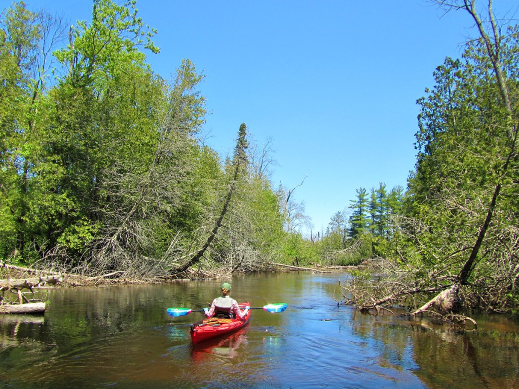
Other than finding a place to leave your vehicle, the access at the southern-most Au Train Forest Lake Road bridge is excellent: flat and gravelly, no steep banks or mud. At the time of our trip, the landing looked like a veritable boatyard, with canoes, kayaks, and PFDs scattered in clusters. We went when it was quiet and secluded; but it must be a mob-scene on summer weekends.
At first, the scene is moderately residential and you might well wonder if this is the natural landscape equivalent, relative a national forest, of a gerrymandered political district, for you’ll pass by a handful of lawns and swanky “cottages” with steep staircases, docks, and piers. But these will all vanish behind you after a 1000′, past which there is zero development for a good five miles. What you will see, instead, is a positively pretty environment with several steep sandbanks supporting pines, astonishingly translucent water with a root-beer hue, and pristine wetlands. The river meanders like a mother******, but you’d have to be a total ***** with a **** and *** to not find your ******* way (Editor’s note: I don’t even know how to fill in these blanks.) Just kidding. It does squiggle this way and that, and is only 50′ wide or so, but given the commercial-recreational footprint of the river, it appeared well maintained, so deadfall shouldn’t be an issue.
You’ll also pass several day-use recreation areas – all on the right-hand side, which if nothing else confirm the jurisdiction of national forest. All of these have seen better days – or at least have the appearance of having suffered from violent natural events a la lashing winds or high water levels; snapped trees and eroded shoreline surrounded each of these half-dozen or so areas. Or maybe that’s what happens when the river po-po isn’t properly patrolling the blasphemous nudists spouting profanities…? Either way, it’s a strange effect, as half of the time you’re lulled into the feeling of being far away from everything (it is the U.P. after all) until happening upon these seemingly random recreation areas.
In any event, you’ll paddle towards, along, and then away from a subtly tall ridgeline on the west side of the river. Shortly after that you’ll pass by a few more steep sandbanks and then a house on the left – the first since the bridge, but a harbinger of what’s to come, as several others follow. A jog up, down, left, and right, and then suddenly there’s the next bridge – technically, the same Au Train Forest Lake Road. There’s access on each side of the downstream side of the bridge, but both appeared to be the exclusive domain of the rental outfitters, complete with No Parking signs. I’ll just say this one last time: you’ve paddled over five miles, but the land distance between the two bridges is only three-quarters of a mile.
From here, it’s only 2.25 miles to Lake Superior, but it’s important to note that the Au Train is a totally different river in this next leg. Gone is the narrow intimacy, replaced now by sprawling marsh/wetlands and side channels. Gone is the clear water and sandy bottoms, replaced by dark muck. And gone too is the sense of undeveloped abandonment, replaced instead by the obvious sights and sounds of civilization – occasional at first, then increasingly numerous – houses, roads, highway tires. By and by, it’s not an unpleasant segment; it’s just a night-and-day difference. After the bridge the river braids, and it is not entirely intuitive where the main channel is, especially since there’s really no current anymore. It’s helpful to bear in mind that it flows northeast before turning west on a dime and then north again to the big lake. There are a couple places where it clearly looks like the main channel goes to the left (west) – and you certainly can go that way, but it will take you only to the east; and all you’ll see are the backyards of euphemistic cottages. But if you hug the cattail-lined right side of the river you’ll cut off the excess. That is, until an indistinct point where the river kind of dead-ends and you have to choose to go left or go right. Here, you want to go left, as the right simply backs up to a marsh but goes nowhere after that.
You’ll pass under an old closed bridge and a wavy set of meanders left and right to the west past what seriously looks like a plot of suburbia just plopped down by aliens. A welcome distraction from that is the reappearance of sandy banks portending the proximity of Lake Superior beguilingly near. One last steep bend to the right, and then it’s a sure shot north past an ATV trail bridge, then Highway 28, and finally the majesty of Lake Superior. Depending on the sandy vagaries, you may get stuck in shallows. But it is absolutely worth the effort to make it out to the lake. At the mouth, there’s a lovely beach complex to the left and right with intact dunes. While you can land here, there’s nowhere to take out per se. And at the time of our trip, the beach was closed off from the parking area for no explicable reason. So, we simply savored the moment and scene, then high-tailed it upstream to the ATV trail bridge again, where there is one of those paddling floating docks/piers fit for ADA access and accessible to all – not exactly the made-for-movie scene I was hoping to end our little trip at, but undeniably convenient.
What we liked:
The Au Train is such a pretty little river! It was surprisingly deep during our paddle, yet was bathtub warm. Mind you, this is a north-running stream in the U.P. in June – where there was still snow only a month earlier, and virtually no rain. How the volume was so plentiful and why the temperature was so warm is beyond even my best guess. But it was lovely. Being able to clearly see 3-4′ down is a novelty and a real treat. The wildlife was wonderful, too, with sandhill cranes and a variety of turtles being the highlights. Gorgeous water, engaging wildlife, and a seemingly pristine landscape through the outskirts of a national forest – there’s a lot to like here!
While the second “half” of this trip is nothing like the first, we enjoyed navigating the sprawling marsh complex to find at last that rugged and wild feeling of a river’s natural mouth at an oceanic body of water the likes of Lake Superior. Not as dramatic as other tributaries and perhaps detracted by the presence of a state highway, the effect is still powerful, and the pull towards the world’s largest freshwater lake undeniable. I have no idea why the beach here is closed off via the parking area, but it’s a beautiful stretch – especially with the dunes.
Finally, there was our laughably facile bike shuttle, which was awesome.
What we didn’t like:
Not gonna lie: the second “half” is a bit lackluster and monotonous. If the wind is out of the north, as it was for our trip, prepare to be buffeted. I could have done without the “suddenly suburbia” feeling superimposed on the landscape so close to Lake Superior.
If we did this trip again:
Wouldn’t change a thing. Is the stretch from the second bridge to the Lake worth it? Only you can decide that for yourself. The landscape change from national forest to sprawling wetlands to suburbia is something of a transmogrification, to be sure. And the one-trick pony effect of river-to-sea finale that is the mouth of the Au Train at Lake Superior is a bit subdued by the highway (not to mention the beach basically being closed off), but it’s a pretty pony all the same.
Regardless, you’d do well to skip this trip on summer weekends (unless of course you want to share the river with scantily clad louts, drunks, and gutter-mouthed hooligans). I think we dodged a bullet and were lucky to paddle the river when we did. Choo choo and cue either “Take the A Train” or anything by Coltrane.
Disclaimer: “au train” is from the French for “to the traverse” or “at the shortcut,” and has not a darn thing to do with railroads or subways.
***************
Related Information:
Camp: Hiawatha National Forest
General: Au River Canoe Trail
Wikipedia: Au Train River
Photo Gallery:


No Comments