
Touring Lower Six Mile Creek:
A delightful little jaunt in the Madison area, the lower half of Sixmile Creek offers a pleasant respite without the commitment of a long drive or shuttling (it’s a there-and-back outing), plus a wide array of wildlife and undeveloped surroundings.

Rating: ☆ ☆ ☆
Trip Report Date: August 22, 2021
Skill Level: Beginner
Class Difficulty: Flatwater
Gradient:
≈ 1′ per mile
Gauge Recorded on this Trip:
Waunakee: ht/ft: 2.77 | cfs: 6.5
Current Levels:
Waunakee: ht/ft: 2.24 | cfs: 7.43
Recommended Levels:
There is always enough water to paddle this trip.
Put-In + Take-Out:
N. Shore Bay Drive, Waunakee, Wisconsin
GPS: 43.14093, -89.43756
Time: Put in at 4:30p. Out at 7:00p.
Total Time: 2h 30m
Miles Paddled: 5.5 (there and back)
Wildlife:
Great blue herons, green herons, songbirds, muskrat and deer.

Background:
Sometimes you just need to be on the water, doesn’t really matter where or for how long. That might sound tautological for a paddling blog, so let me clearer. Sometimes you just need to be in a boat, on a body of water, surrounded by nature, away from everything else. That could be ten hours away or ten minutes. (In this case, for me, it was literally less than 10 minutes.) For me, whose mantra is my favorite place to go is somewhere new, it’s easy to be “farsighted” about paddling, my eyes typically on a prize that’s a way’s away. But all that takes time and rarely packs conveniently into schedules of work, weather, dog-sittting, etc. Still, that’s generally how I roll. Yet, for all that outbound wanderlust coursing through my veins, even I can rein it in sometimes and pleasantly settle on paddling Badfish Creek for the 50th time or a similar nearby stream. Or, in this case a virtually current-free marsh-area stream with no need to shuttle.
We’ve been on the upper half of Six Mile before (technically, it’s the mid-section of the creek, but trying to paddle the headwaters of Six Mile into Waunakee is a fool’s errand full of downfall and low-clearance bridges), and this is a distinctly different experience. It’s one of two streams that feed Lake Mendota at the same exact spot (the other is Dorn Creek) in between Cherokee Marsh and Governor Nelson State Park.
Before I knew much about paddling, I was in a long aluminum canoe with my then girlfriend and her best friend back in 2009 and we went up Six Mile Creek for about as long as we could until portaging became too problematic; and so we turned around and floated downstream back to the car. That’s likely what everyone does. The question that remains is this: how far up do you venture before calling it quits and heading back? For me, now in 2021 – a dozen years later and about as many girlfriends, too, not to mention becoming a part of a paddling blog and eventually writing a paddling guidebook – a lot has changed. But mainly I wanted to brave as far up as Woodland Drive before turning back around. I got close, but the amount of deadfall and general tree debris got to be too formidable and ridiculous, the banks too mucky and gross to get in and out a lot, and the spiders way too numerous.
But I was delighted to see a total of seven kayakers during my outing – in groups of three and two, plus two soloists fishing. So, whether it’s the ongoing pandemic inspiring people to paddle anywhere and everywhere or what, I don’t know. But the secret’s out about Six Mile Creek.
Overview:
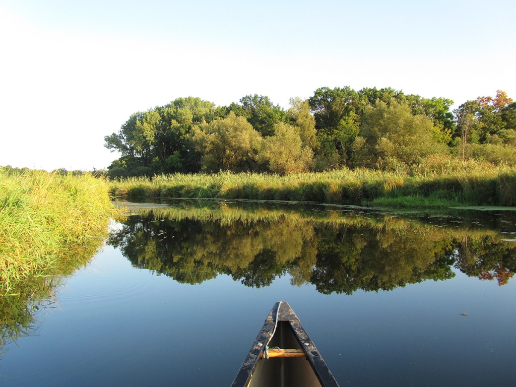
There’s good access to the water at the bridge (downstream side, river-left) that serves as both put-in and take-out since this a there-and-back paddle trip. For only a hundred yards or so you’ll comb through lily pads, cattails, and marsh grass before the scene blows wide open in a lake-like setting. Essentially, this is where Dorn Creek and Six Mile Creek merge before emptying into Lake Mendota (off to the right/east). Here, you turn left, however, and paddle upstream and north. The current is next to nonexistent, so this poses no difficulty or particular hardship. The settings are still quite wide here and will remain as much until the bridge at County M, preceded first by a brand new handsome pedestrian bridge that is mostly used by bicyclists. On the other side of the road bridge the creek will bend to the left, and then right through a quintessential marsh and prairie environment, now only a narrow stream that is 20′ wide at best.
I learned once, somewhere, that the difference between a marsh and a swamp is this: trees. A swamp has trees, a marsh doesn’t – or at least not as many and mainly on the perimeters. Depending on your druthers for venturing upstream, you’ll likely be in a predominantly marshy landscape, and on a sunny day your skin will just bask (or be braised).
There are occasional straightaways, but it’s mostly a lot of meandering – a couple times the creek will even make jackknife-like tight turns fully 180 degrees. The signature feature here is abandoned nature of the landscape. Hardly a wilderness, it still feels wild thanks to the lack of development. To be sure, civilization surrounds the marshy environs, but you don’t really see any of it while on the water. Indeed, once you get past County M the only building you’ll see is part of a horse…farm? ranch? stables?
I remembered the horses from that first paddle trip a hundred years ago. This time around when I passed one party of two paddlers in kayaks I asked them how far up they were able to go, and they answered “you can go up quite a ways. You’ll see where we turned around.” I’ll see about that, I thought privately, although my Taurean obstinacy had to be tempered by the reality of sitting high up in a long boat, a 15′ canoe. (It’s funny to me that the only times I’ve paddled this narrow-ass creek full of deadfall have both been in canoes). I liked the challenge of that as well as the ambiguity; for each and every time I encountered an obstacle – and there are plenty! – I kept wondering Is this where they turned around or is this where turned around…? The first was a low-clearance tree you have to lean all the way forward for or limbo all the way back – or when in a canoe lie down inside and hope the gunwales clear. This tree presumably lies on private land as it was a few feet away from two patio chairs, at least at the time of this writing. If my canoe can get under it, a kayaker should have no trouble.
This whole trip is a kind of choose your own adventure insofar as how far up you paddle. In other words, how willing you are to paddle upstream and into/onto tree debris. Again, the current isn’t really an issue, but in late summer – especially a hot one like this year – there’s an explosion of aquatic plants and weeds, which, together with low water levels, slow you down considerably.
Pressing on, you’ll soon come upon a seemingly totally random wooden bridge that is part of Carriage Ridge Conservancy surrounding the creek here. A half-dozen zigs and zags follow on the other side of the bridge, and then a long straightaway. After that the landscape changes on a dime, ditching its marsh and prairie airs and adopting a new attitude that is 100 percent swampy bottomlands and woodlots. Even the streambed changes from sandy gravel to muddy muck. And all that former golden sunlight of infinite summer, it’s gone, shrouded now by portentous trees lending an atmosphere of spooky gloom. Is this where they turned around…? Not surprisingly, there’s a lot of downed trees here – strainers, stray branches, akimbo limbs. I cut through a fair amount of the truly impenetrable stuff with my trusty Cindy Loppers, but passing through still is akin to threading a needle in some places (especially in a canoe). But don’t let the mud or obstacle course or darkness mislead you; this part of the trip is actually pretty cool and even pretty in its own way, especially with a couple of modest weeping seeps and natural springs.
But I did give up after a time before getting to my arbitrary ideal of Woodland Drive (aptly named, come to think of it). I could hear vehicles and traffic, so I knew I was near, but it seemed silly at best and indisputably impractical at worst to keep pressing on…for what? That said, wherever I was when I decided to turn around I was quite certain it was farther than the two kayakers had gone, believe you me, by golly! There’s stubbornly negotiating some blockages and impediments without having to get out of your boat, but then there are some clusters you can’t avoid without portaging. Either way, everything you do once will have to be done twice on a trip like this, since it’s there-and-back. Hence turning around before the impractical became ludicrous and laughable.
That’s basically the first half of the trip; everything else is just played in reverse, the only difference being now you’re marginally going with the flow and replaying scenes from your memory, be they from an hour before or a decade.
What we liked:
When you need a quick booster shot of “vitamin P” but don’t have all day, this little number is quite efficacious! It helps that the landscape is quite lovely and mostly undeveloped, despite being on the fringe of the second largest city in all of Wisconsin. I loved the mere simplicity of this trip – how close it is to my driveway as well as the voided necessity of shuttling (and all those jazzy logistics).
What we didn’t like:
Don’t get me wrong – this is still predominantly a marsh environment (with the unruly woods upstream as a kind of “bonus feature” if this were a DVD, which does not necessarily strike of chord of resounding extraordinariness for most paddlers (myself included).And, to be fair, paddling upstream still makes me flinch and snicker with nonplussed reservation. Furthermore, if you do venture far enough to get into those unruly woods where “paddling” has been superseded by a kind of crossfit-equivalent of extreme landscaping, well, that can quickly get tiring and dispiriting. Oh – and messy. I’m not so fastidious as to be flustered by a small storm’s worth of broken branches, leaves, twigs, and assorted arboreal debris from snapping, snipping, and sawing my way through the maze and obstacles. No, sir. But what I do mind is the amount of rogue spiders now having fallen into my boat (a hopelessly wide open canoe at that) and onto my body. After a dozen or so – and big, ugly ones at that, not the mindlessly harmless daddy longlegs variety at that – I started debating in my head on a scale of 1 to 10 how much of an overreaction or hypercorrection it would be if I just lit the canoe on fire and ran screaming out of the woods. Of course, all of that was my own doing – it was I who disturbed them; I get that. Still could’ve done without it, though.
If we did this trip again:
I’d definitely do this trip again, as is. The only difference would be A) taking a sawzall or chainsaw with me and B) do it either earlier in the year or even later, to avoid all the weeds and aquatic plants.
This little junket was just what the doctor ordered: a quick escape for the sake of being on the water on a day when something more ambitious wasn’t in my cards. It’s easy to get to and be at. The wildlife was delightful and the overall wild-esque landscape with hardly any development – despite being surrounded by such – lent the whole experience a unique feel.
The one thing I rue about paddling in general (at least rivers) is all the work it takes – loading a boat on a vehicle, getting all the gear, driving to the destination, doing a shuttle, etc. (And let’s not even get into the whole smorgasbord of weather and water levels.) It’s entirely different from road or mountain biking, or skiing, or running. For instance, let’s say your destination is 45-60 minutes away and maybe 7 miles long, which is a pretty good average. That all sounds neat and tidy in and of itself and none too formidable, but the reality is that’s gonna be the better part of your day: the driving time alone, round-trip, is 90 minutes to two hours + half an hour realistically for shuttling + 2-4 hours on the water (depending on your pace and size of your party). Totally worth it – and something I do damn near every single weekend from April to November (and at least once a month from December to March) – but it is a time commitment, no two ways about it.
Perhaps that it explains the explosive popularity of SUPs and lake paddling…? That and social media.
Thus the appeal of a trip like this: slipping on and off the water as you please, only minutes away, and no worries of leaving a car somewhere and how many boats can it take and the headache of getting back to the put-in, etc. I love me an adventure like nobody’s business, the more recluse and obscure the better. But sometimes there are too many chores to do and not enough time for somewhere sexy. A trip like this is a perfect compromise.
***************
Related Information:
Six Mile Creek I: Waunakee Village Park to South Woodland Drive
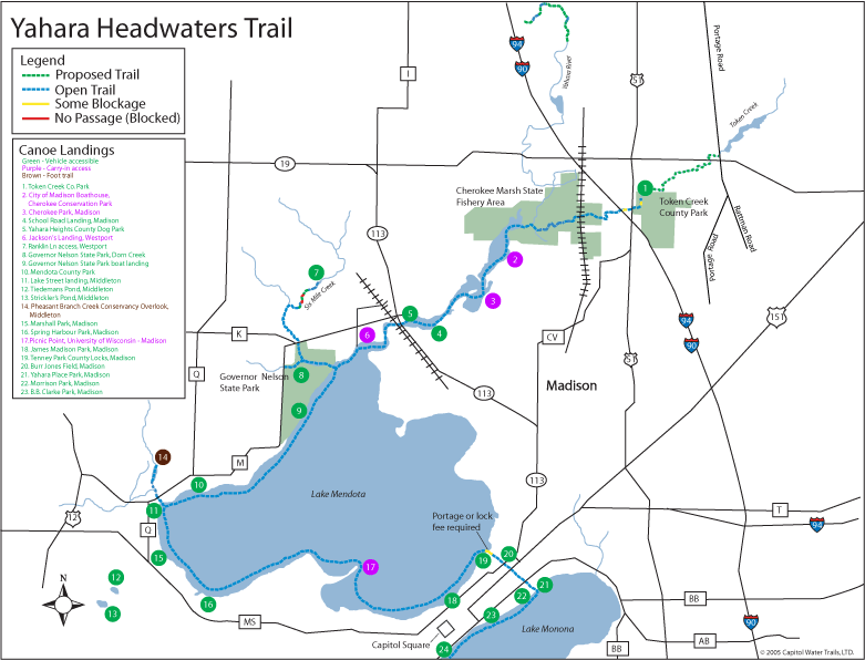
Map: Capitol Water Trails
Photo Gallery:


1 Comment
Rick Hannah
August 25, 2022 at 11:56 amThe time commitment in paddling can be a bit of a pain. However, once on the water, all that effort is rewarded, as I slip into my zen place.