
Columbus to Astico Park:
A far more interesting paddle than I ever expected due to a surprising amount of variety – provided, you enjoy some wide-river paddling. The first half is narrow and intimate with easily-navigable deadfall followed by a section strewn with boulders, boulder gardens, and delightful riffles. The second half transitions to a broader and deeper body more typical of the Crawfish, but bonus points are given for the wonderful Astico Park campground awaiting at the end which offers a convenient and compelling overnight riverside camping option pre- or post-paddle.


Rating: ☆ ☆ ☆ ☆
Trip Report Date: October 11, 2022
Skill Level: Beginner
Class Difficulty: Riffles
Gradient:
≈ 1.8′ per mile.
Gauge Recorded on this Trip:
Beaver Dam: ht/ft: 839.87 | cfs: 118
Current Levels:
Beaver Dam: ht/ft: 839.16 | cfs: 33.9
Visual Gauge:
Crawfish River Visual Gauge
This picture of the dam at the Columbus put-in might help determine whether your trip would be similar to this one. In this specific case, I’d suggest a higher watermark than what it currently shows.
Recommended Levels:
Beaver Dam is a correlative gauge so it’s no surprise that it’s not an entirely accurate way of gauging water levels. In Timothy Bauer’s guide Canoeing & Kayaking South Central Wisconsin, he recommends a minimum of 60cfs on the Beaver Dam gauge to avoid scraping. However, I would recommend a minimum of at least double, maybe even 150, because these were low levels. It was completely doable, but there’s a wonderful section full of boulder gardens and/or ledges that was a bit bumpy at 118, suggesting it requires more water. You’ll enjoy it at higher levels than these to fully realize the riffles and small drops throughout. At the same time, this river is prone to flooding and the first half of this trip wouldn’t be safe at very high levels due to all the deadfall and potential strainers. So just a bit higher is ideal.
Put-In:
Udey Street Dam off Campbell Street, Columbus, Wisconsin
GPS: 43.33718, -89.01019
Take-Out:
Astico Park bridge
GPS: 43.32613, -88.94934
Time: Put in at 10:50a. Out at 1:20p.
Total Time: 2h 30m
Miles Paddled: 8.5
Wildlife:
Fish, ducks, geese, heron aplenty, a beaver and a bald eagle.
Shuttle Information:
4 miles. This half-rural/half-highway jaunt is a short 20-minute bike shuttle, but that half along Highway 60 is a busy one. Thankfully, it has a decent shoulder.

Background:
To be honest, the Crawfish is rarely top of mind when I’m considering places to paddle. I reported on a section much further downstream years ago (one of dozens, I’ll admit, deserves a proper update) which set my opinion on the entire river and its appeal (which wasn’t very complementary). But I’ve since driven over it numerous times throughout the years, always thinking, “yeah, I should probably revisit it.” Those are usually days where I’m headed somewhere far less alluring than being on a river – any river that day. But let’s be real, it’s flat, it’s wide, and it looks slow, (and mostly is) which is why it’s been dubbed the “Crawl-Fish.” But this section is a bit of a contrarian, because it’s one of the few sections of the river that offers far more than what you might glean from casually driving over it.
Weather entirely instigated this trip on this day. It was not where I was intending to venture, but it was on my rainy day list of places to visit. It’s also a section that wasn’t on our site, but was featured in (fellow Miles Paddler) Timothy Bauer’s guidebook, (and longest-titled book, ever) Canoeing & Kayaking South Central Wisconsin, 60 Paddling Adventures Within 60 Miles of Madison.
We’ve shared pieces (parts?) of the Crawfish to this site that are covered in his guidebook, but not all. And we didn’t have this one. To be completely honest, this is the first time I’ve used his book to inspire a new adventure and get me where I wanted to go, so I finally felt like the investment of a few copies finally paid off! Timothy, of course, does a wonderfully accurate job with his write-up and description. But it’s funny what one reads and retains. Or at least, what I took away.
What I didn’t focus on was his description of “a surprising amount of diversity” or “an unexpected boulder garden with riffles and light rapids adds a spike of fun to an otherwise lazy float trip.” No, I completely blew by those headlines. So it came to my utter surprise and delight that the first part of this trip is really interesting. And aesthetically not what I expected with riffles, numerous boulders, mini-boulder gardens, small ledges, and sometimes even creek-like canopied sections.
But who really reads copy, right? I mean, are you actually reading this right now and committing it to memory or are you simply skimming it?
What I did focus on instead was his mention of a “bizarre loop” where he notes a humongous logjam on the left before a footbridge. So my attention was dialed into the impending deadfall (and potential portage) while completely ignoring all the good described in that upstream portion. I think that only added to my surprise and enjoyment of the trip, despite focusing on the bad. But hey, it’s rather human to remember the bad while overlooking the good, right?
One element I really enjoyed was paddling this in fall. It wasn’t entirely coincidental in choosing to check this off the rainy day list at this particular time, though. It was me hedging, because even the most mundane of paddles can look a little better in fall. There’s just something kind of special about fall paddling. The crispness of the air, the crunch of leaves on both land and water, the visual of leaves floating on the surface taking on the trail/shape of the current, and of course, the colors of Wisconsin’s fall palette. It just adds a different dimension and it’s incredibly appealing.
Spring is a great time to visit rivers and creeks before all their foliage comes in because you’ll see more in the barren landscape that you might otherwise not. But conversely, fall can make even the slowest and lackadaisical woodsy paddles more interesting. The Crawfish is one of those rivers. The colors can make up for the humdrum in stunning ways, or even in a simple lonesome stretch where one underdog tree shows off its color – something no one else would ever witness because it’s only accessible by boat on a random riverbank.
Read more about fall paddling Wisconsin in my first-ever guidebook, Canoeing & Kayaking South Central Wisconsin, 60 Fall Paddling Adventures Within 60 Miles of Madison Hue Should Really Check Out, by Barry Kalpinski. Coming in 2034 (or, probably not really ever).
One last notable and convenient aspect to this trip is its ending at Astico Park. There, you’ll find some great river-side camping options which would make for an ideal finish to this day trip, especially since the back-half of it’s wider and slower. You could simply float back to camp towards the northeast point of the park and take-out tent-side.
Overview:
Parking at the put-in is located along the unmarked and unpaved gravel road at the top of the Udey Street dam in Columbus. Access to the water is just below, where depending on water levels can be from a variety of positions and/or openings as there’s a lot of rocks, boulders and rubble scattered about.
After setting off, the sound of the water pouring from the dam quickly recedes as you paddle through a narrow backyard passage and below the County Line bridge. It’s wild-feeling, mostly-canopied, and gets scrubbier with more and more deadfall along the banks that provide hideaways for many, many ducks. The water was really clear, but it was also very shallow – much of the time only 6″ deep – which highlighted just how abused this stretch of river was due to its proximity to population and their garbage. I made a game of counting the tires I’d pass over (I counted nine in just the first twenty minutes). But that aside, the secluded environment is wonderful and that continues, though a bit wider, for the next stretch.
The river soon doubles back on itself on its way towards River Road. This was what Timothy references as a “bizarre loop” (it looks like a foot from above if you look at it on Google Maps.) There are huge piles of deadfall from the hardwoods that surround the banks, but they were all negotiable and nothing hairy to contend with.
But what’s funny is that I kept thinking about that one giant mound of deadfall mentioned in the guide. Every pile I’d think, “Is it this one? Maybe it’s this one? No, it definitely had to be this one he’s talking about.” But in reality, there are piles everywhere for quite awhile and many of them, quite impressive. The chance that I’d know exactly which one he was referencing was absurd, and it was highly unlikely with so much time between that report and this visit that it was still in the same condition or even sitting in the same place in the streambed. Regardless, it didn’t really matter. There were no portages.
Prior to the private footbridge is a quaint section that gets narrow around a bend. It’s really pretty with small boulder gardens and some larger boulders scattered throughout. After the footbridge, the river bends to the left in a long arcing curve where the surroundings open and River Road abuts river-right for a bit, jogs for a moment, and then returns alongside the road as a long straightaway. That entire straightaway is wide open, so if you have a headwind, it’s not ideal (trust me).
River Road is soon in the rear-view as the stream takes a turn physically heading northeast where it becomes narrow and canopied again – and also much more interesting. It gets crazy (in only the way you’d expect that the understated Crawfish River can get crazy) with many more boulders and many small boulder gardens. There are “lines” or fence-like settings of boulders throughout (that also can be seen from Google Maps) that create small ledges. Some are certainly man-made but others appeared natural.
This change in the makeup was completely unexpected but also quite welcome for the next mile and a half or so. I had no idea the Crawfish had these kind of boulder gardens. It was pretty and fun, but the water was looowww – much lower than I’d suggest for running this section.
I made it through alright, but it required a certain maneuver to distribute my weight. Most paddlers know what maneuver I’m talking about. It’s where you lean back over your seat as far as possible to even-out your weight which helps float over the shallowest of water. Almost like planking. It works, but it can hurt, and at long intervals, it’s pretty unsustainable from a comfort POV.
It can be so uncomfortable in fact, that I thought to myself “this has to be a yoga move.” When I got home, I actually asked my (yogi) wife (and First Lady of Miles Paddled) if there was a similar move as I demonstrated the flattening of my body while in an invisible boat.
Coincidentally and ironically, she told me “yep, it’s called low-boat.” I was stunned. I mean really, how perfect is that? I think I responded, “you’re shitting me?!” For years there’s not only been a name for this maneuver, but it’s also a yoga position and it’s perfectly named? Then I wondered which came first? Like the chicken and egg thing. Then I went through a stage of, “Wait, so I’ve yoga’d while kayaking? I’m a dual-threat paddler and a low-boating pro?” (The next day, the shine wore off this revelation when my bruised back told me to stick to solo sports and also watch water levels.)
After the last of the boulders, there’s another long straightaway where the river widens (and thankfully deepens if you’ve been low-boating) as it bends to the right. From here on out, the last half of the trip is more like most of the Crawfish. Not only is it wider and deeper, it keeps getting deeper and almost stagnant at times before the Ninabuck Road bridge. But soon the river grows even wider before its widest berth at over 200′ (compared to the first half at 70-100′) downstream from County Road TT which marks the beginning of Astico Park on river-right.
The river winds widely around the peninsular park and campground where you can catch a glimpse of some of the appealing riverside campsites which were adorned nicely in reds, oranges and golds this time of year. Soon, you’ll see the Astico Park pedestrian bridge in the distance and spot the dock and takeout on river-left. It’s a very picturesque exit to the trip.
Downstream is Jaeger Mill, located at the top of the Danville Dam. It’s an Insta-worthy mill which can also be instantly-viewed via Highway T if you don’t want to paddle the wide berth down-and-back to Astico Park.
What we liked:
Half of the trip was what I expected – wide and slow. It was the other half that surprised me pleasantly (maybe even amazingly.) It was just so interesting with so much more diversity than anticipated (again, maybe I should’ve read that guidebook a little closer).
Plus, I love that this has the makings for a great paddle-camp option. It’s that extra cherry on top that gives this paddle an extra star on top of already being a solid 3-star paddle throughout. Add to that, I love how close this is to Madison for a quick daytrip – with or without the added overnight option.
Lastly, it was especially pretty in fall.
What we didn’t like:
I can’t really think of anything. The second half is flat, wide, and slow, but that part was expected so I can’t knock it.
If we did this trip again:
I’ll definitely revisit this trip again, but at higher water levels to really appreciate that second quarter with the boulder gardens. And next time, I’ll likely take advantage of the Astico Park campground to celebrate the day’s trip at one of those riverside sites.
***************
Related Information:
Crawfish River I: Milford to Jefferson
Crawfish River II: Olson Road to Aztalan State Park
Crawfish River III: County Road I to County Road G
Camp: Astico County Park
Wikipedia: Crawfish River
Miles Paddled Video:
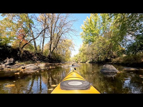
Photo Gallery:


No Comments