
County Road O to Banfield Bridge Recreation Area:
This trip on the hitherto unexplored lower Little Platte River will reward paddlers with swift riffles and stunning rock outcrops in the beginning, a wild sense of solitude in the middle through much slower water, and abundant wildlife throughout. On the downside, this is a long trip out of necessity, with no good accesses until the take-out. Midway through, there are several logjams requiring difficult portages, not to mention down trees aplenty that will inspire creative agility to maneuver around, over, or under. Accordingly, due to the long distance and obstacle courses, this should be considered for intrepid paddlers only.

Rating: ☆ ☆ ☆
Trip Report Date: June 28, 2018
Skill Level: Intermediate
Class Difficulty: Class I
Gradient:
≈8 feet per mile the first 5 miles, ≈2 feet per mile for the remainder
Gauge Recorded on this Trip:
Rockville (Platte River): ht/ft: 4.27 | cfs: 235
Gauge note: The Platte River is a correlative gauge.
Current Levels:
Rockville (Platte River): ht/ft: 4.02 | cfs: 95.7
Recommended Levels:
This is the recommended minimum level. Ideally, look for 4.5′ on the gauge to avoid scraping in the first 5 miles.
Put-In:
County Road O, Cornelia, Wisconsin
GPS: 42.68966, -90.56429
Take-Out:
Banfield Bridge Recreation Area, West Banfield Road, West of Dickeyville, Wisconsin
GPS: 42.63097, -90.65305
Time: Put in at 12:30p. Out at 6:00p.
Total Time: 5h 30m
Miles Paddled: 15
Wildlife:
Bald eagles, great blue herons, swallows, songbirds, muskrats, turtles, owl, tiny snake, pelicans and sandhill cranes.
Shuttle Information:
12 miles. Spectacularly scenic, but long. And hilly as all hell.

Background:
We first explored the Little Platte back in July 2013, 2016, and 2017. Those trips were and remain some of the very best “pioneer paddling” we’ve ever done. Rapids galore, rock outcrops everywhere, astounding wildlife, mile after mile – at least the segment of river from Old Lancaster Road, just west of downtown Platteville, to County Road O, out in the countryside of Cornelia. Since 2013 we’ve wondered all but salaciously about the lower Little Platte River – i.e., downstream of County O. Not that there was a whole lot of info or intel on the “regular” Little Platte River, but there’s just nothing out there on the final miles of the lower Little Platte. The absence of even a scant breath was conspicuous. Why? For a river so spectacular in one segment, there’s just nothing about any other portion of it?!? The omission was peculiar to say the least. So, we got to forming an exploratory committee.
The topo map of the area in question looked very promising; the little river bounces off one bluff after another like a pinball, with enough reason to expect exposed rock outcrops the way a minerals speculator would twiddle his fingertips, imagining future benjamins just raining down from mine shafts. Plus, being further downstream, it stood to reason that water levels wouldn’t be quite as fickle as they are in the Old Lancaster Road to County O trip. The Little Platte is one of those rivers you must wait to paddle til it is high enough, not just because you want to go there. (Well, of course you can, but you’ll be scraping and/or walking your boat more than paddling it, which is half as much fun as visiting the dentist for a filling or filing taxes.) Nonetheless, it would be a fool’s errand to bother making the drive down to this part of the state if the gauge is below 4′. Frankly, because the gauge on the main Platte River is still just a correlation, the level should be even higher than 4′ so as to cruise without scraping and rendering your boat’s bottom a carpenter’s plane.
Suffice it to say, it’s rare for the gauge to read above 4′. Even when it does, it doesn’t stay there for too long. Timing is everything. As much as we like to joke that when such-and-such a river reaches such-and-such a stage, you call in sick to work, a little thing called reality often gets in the way of that. (Stupid reality!) That’s half the reason why it’s taken five years to do this trip. The other half is logistics. While there are three bridges between the put-in and take-out, not a single one of them makes a practical access. And by “practical” we mean the least bit remotely feasible. The first two bridges – Church and Oak roads, respectively – both are carpeted in dense, waist-high leafy green plants/weeds that may or may not be poisonous (but why even take the risk of finding out?), along steep muddy banks, surrounded by private property, and with no real parking roadside. Is either doable? Sure, but for only 1% of realistic folks. Both would be a huge pain in the ass, where you’d be best to have a grappling hook and rappelling rope. The third bridge is Highway 61, which is absolutely a no-go; it’s a fast, busy highway where there’s nowhere to park or access to the water. Thus, to do this trip commits one to a long day of 15 miles, past the confluence with the main Platte River, down to the Banfield Bridge Recreation Area, where there’s an excellent access 1.5 miles upstream from the mighty Mississippi River. And if the paddling is 15 miles, you can only imagine how long the shuttle is… Llllooooonnnggggggg. And hilly as all hell.
And so like any exploratory committee worth its salt, it took us five years to make a run for office.
There was an added serendipity to this trip. Our pal, Jeff Jackson, the Stewardship Specialist of the Southwest Badger Resource Conservation & Development Council, joined us as part of a fact-finding expedition to identify and locate Japanese hops, an aquatic invasive species (AIS) run amok in Wisconsin. Our modest mission was to specifically locate the presence of the invader in various corridors along the river and then report that data to the DNR so as to target a riparian zone for future volunteer removal efforts. For example, the north bank of the Little Platte River east of Church Road. What we found, to our shock and dismay, was a kind of low-budget horror movie/X-Files episode where some sentient menace spreads ubiquitously over everything – banks, boulders, power lines, even downed trees. In places it was so thick, it was kind of cool. But, of course, not. Indeed, we found Japanese hops running along the riverside corridor pretty much continually for 12ish of the 15 total miles in this trip. In other words, it’s pretty much an infestation.
Those of you familiar with our blog might have noted that, unlike Barry who can’t get enough of the stuff, Timothy is no fan to hops when it comes to his beer druthers. In fact, a hopless beer would be ideal. (That one’s for free, microbrewers out there. Put it in your hopper!) Regardless, unlike Cascade or Chinook, Saaz or Willamette, Japanese hops are not used in brewing. A pity it’s not for those who do like their beer bitter, given the rampant presence of the stuff in Wisconsin’s waterways. Still though, if you can make a pesto out of garlic mustard, why not a one-off IPA with Japanese hops?)
Anyhoo, in part because we mapped out this trip in separate segments between bridges, but mainly because these river segments are uniquely idiosyncratic and unlike what precedes or follows each, we’re going to write this report a bit differently than our standard affair. To be sure, where these bridges straddle the river is nothing more than an arbitrary, artificial separation created by humans who needed a way to get to the other side. The river is just doing its thing precisely as it has had for many millions of years. However, these bridges do allow for an uncanny demarcation partitioning individual character traits from segment to segment. Also and equally uncanny, each bridge-to-bridge segment is 4-ish miles until Highway 61. Jeff and I likened it to different chapters in a novella. After all, what is a river but a story? You’re constantly moving from a beginning to an end, with who knows what in between? This is true for any river, as conditions change all the time. But it’s an especially potent novelty when pioneer paddling. Having never been here before and knowing not what to expect, we were excited about this all-day journey.
Before we start this story, just keep in mind please that we’re treating these bridges solely as arbitrary boundaries, with no intended suggestion that one can put-in or take-out at any of these roads as a kind of a la carte trip. One can’t. To do this trip at all is for all intents and purposes a full 15-mile commitment.
Cool? OK, let’s go!
Overview:
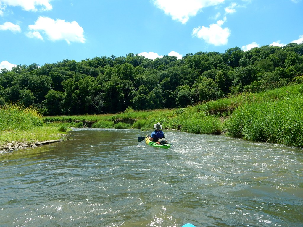
County Rd O to Church Road (≈5 miles): The put-in at County Road O is on the downstream side of the bridge, on river-left. It’s a rugged access point – it’s rocky, weedy, and the incline from the river to the road is a smidge steep, not to mention a touch muddy at the water’s edge – but it’s really not a hardship; the bank here is water-level, and there are some large rocks embedded in the bank to avoid getting muddy.
In every sense, this segment continues in character as the better known Little Platte River does upstream: it’s rowdy and rollicking with frisky riffles and little ledges galore; it courses through steep hillsides and bluffs; and is lined with stunning rock outcrop walls. All right, lower Little Platte, I see what you’re doing here…Unless you don’t like rock outcrops, boulders, and fun rapids, this near 5-mile clip is the funnest and most rugged segment of this trip. It’s a classic pool-riffle-pool stream, meaning riffles will be followed by quietwater tranquility… for a moment, only to hustle again and scamper downstream. It’s also for this reason that we can’t stress enough that the Little Platte must be paddled when the main Platte River’s gauge reads above 4′. (Although don’t let us get in the way if you want to donate curlicues of scraped plastic from your boat to the riverine environment. Lord knows my boat has shed the better part of a whole duct tape roll, which pieces are probably making their way down to New Orleans by now, or the Atlantic Ocean via Lake Michigan.)
After an initial enclosed rock wall the river flows through an open pasture then makes a hard left-hand turn to an especially striking rock wall. Little ledges follow. We happened upon a totally random advertisement for Wollersheim Winery stuck in the left bank. At first glance it looked like a large sign or small billboard. Upon closer inspection we saw that it’s actually part of semi-trailer! (More on this below.) At a north bend the river will split around a large island; take the right channel and duck under the huge tree (the left channel, even without the tree, was a no-go). A huge looming bluff faces you as you sail eastward, behind which is Highway 151 (which wasn’t as audible as we’d feared it would be). A very pretty section follows, with that steep hillside from the bluff framing the left bank, with gorgeous boulders, rock outcrops, and riffles.
The landscape will open up to an especially lovely country vignette, with soft pastoral hills in the backdrop, a sheen of green against a blue sky. One more thin slip through woods and riffles follows, and then you’ll see the Church Road bridge in a straightaway. End chapter 1.
Church Road to Oak Road (4.25 miles): As if someone flipped a switch, the river really changes personalities below Church Road. First of all, gone are the riffles. Just gone. For better or worse, from here on water level concerns are a whimsy of the past (part of this has to do with a substantial feeder creek coming in from the left bank, but it’s also because there’s just no more notable gradient). Secondly, deadfall clutter starts in earnest. It’s as if the trees had just been holding on to all dear life up to this point, and below Church Road, gave up the ghost. Some of the obstacle course was negotiable with flexible maneuvering and stubborn will, but we did have to portage once – going over a bank-to-bank fallen tree, rather than enduring the sloppy slog through mucky mud by getting out and going around.
There still are bluffs in this segment, but no more rock outcrops or boulders. It’s mostly bucolic and nondescript. Once again, the next bridge, at Oak Road, will appear in a straightaway. This concludes the somewhat lackluster chapter 2.
Oak Road to Highway 61 (4.25 miles): This segment has a few notable commonalities with its upstream predecessor (slow current, agricultural, cluttered), but it feels downright wild in some spots, jungle-like actually. You’ll see glimpses of bluffs through the treelines on both sides of the river. Like any good story, this penultimate chapter is rife with conflict and adversaries, but also resolution! Deadfall is a real problem here. We were subjected to three back-to-back-to-back portages in a sequence that would tax most paddlers’ patience. This stretch of the river has all the look and feel of a floodplain together with sloughed mortal coils of ancient oxbows. As such, all that standing water makes for good breeding grounds for blood-thirsty mosquitoes. So, in addition to getting dirty as all get-out from portaging, now we were bleeding too… like any good protagonists would.
There’s an impressive pedestrian bridge in the middle of the nowhere that is the bottomlands segment. Impressive in that it has pulley chains to raise or lower the whole structure itself – I guess in times of flood stage. Have never seen that before…
The environment does eventually open up, and things get better. A short but cleared straightaway leads to a paddler’s dilemma where a small island splits the river in two channels. The current is so slack here that it’s hard to discern which channel is best. We went left, for no particular reason. What’s kind of cool is, if you went right, you’d be less than 300′ away from the main Platte River, just lurking on the other side of a farm field. Regardless, the mainstream of the Little Platte is flanked by an attractive woodsy hill on the left for 2/3 of a mile. On our trip, the river here was dead calm, with no current. There was a lot of debris bobbing atop the surface, which we surmised was backwater coming from the Mississippi, which was very high at the time.
As elsewhere, a long, broad straightaway precedes the next bridge, at Highway 61. Before you pass it, however, the main Platte River enters the scene on the right. The two converge like a letter ‘Y’ immediately upstream from the bridge. Consider it the denouement concluding chapter 3.
Hwy 61 to Banfield Bridge Recreation Area (1.5 miles): We’ve paddled this short stretch before and knew we were in for a treat. Below the long bridge at Highway 61 is an idyllic setting with hardly any development. Essentially, it’s a backwater of the Mississippi River, only three miles downstream from Highway 61. But the flatwater is surrounded by undulating bluffs, and there seems always to be great waterfowl in this section. For us, it started with a pair of pelicans and then rounded off with a baker’s dozen sandhill cranes. In the past, tundra swans and bald eagles galore. Unless you’re battling against the wind, which can often happen here, take your time to soak up this special scene. It has a subtle Adirondacks feel to it.
Soon enough the bridge at Banfield Recreation Park (technically Indian Creek Road) will come into view. There’s an excellent access at the small wayside park upstream of the bridge, on river-right. There are no facilities here, but plenty of room for parking. Plus it’s where all the babes, ice-cold beer, and hot barbecue were waiting for us once we… Wait a second, that’s the Hollywood version of this story’s ending. Sorry about that!
What we liked:
The first five miles are “classic” Little Platte River: swift, clear current, light rapids, and gorgeous geology. After Church Road the landscape is not without its charm; it’s just not as exotic. But we loved some of the intimate moments that the wooded bluffs and downright jungle-like environment allowed. It was really great to see one singular river meander through such a diversity of landscapes, again lending itself to a book-like journey/story.
After enduring the hardship and challenges of some of the trickier portaging, the long, open straightaways were welcome opportunities to relax. The best of these stretches is where the Little Platte and Platte Rivers come together just upstream from Highway 61. Given the name, we’ll infer that the Little Platte is technically the tributary of the main Platte, but at the confluence they’re apiece. And given the terrain they course through in southwestern Wisconsin, they feel more like twins separated at birth who at long last reunite before giving their all to the mighty Mississippi.
And to that point, there’s a moment, say a hundred yards or more upstream of the bridge at Indian Creek Road/Banfield Recreation Area, where if you squint just right you’ll see the bluffs of Iowa way downstream. It’s a rare purview to see the Mississippi River from 1.5 miles upstream, and the effect is pretty heady. We’re a lucky lot to live so near to this American icon.
On an educational note, we’re so glad and lucky to have paddled with Jeff Jackson of the Southwest Badger Resource Conservation & Development Council. Not only was the company on such a long (and at times dicey) expedition utterly welcome, training our eyes to look for aquatic invasive species was very informative. Oftentimes it’s easy to think of preventing the spread of AIS as the duty of motorboats or anglers with their boots and waders. But we paddlers too have a responsibility to be mindful stewards of the rivers and lakes we play on. From here on, we’re taking a handheld brush with us on our trips to scrub our boats and sandals after we reach a take-out. Thanks Jeff!
On a completely unrelated and random note, here’s the back story to that Wollersheim Wine semi. After taking photos of the semi while paddling, Jeff reached out to Wollersheim both to let them know of their “rogue rig” but also to find out what the story is with it. Turns out that Wollersheim once placed small billboard-sized signs on semis in strategic locations just for mere advertising. How this one got in the Little Platte River remains a bit of a mystery. Probably something like the truck itself and/or the boxcar was auctioned off at some point and picked up on the cheap by a farmer – let’s say for storage. In the last few summers alone we’ve seen some awfully vicious storms rake through southwestern Wisconsin, upwards of half a foot of rain in one setting sometimes. So, our best guess is the boxcar was left a little imprudently close to the edge of a field some years back, and a flood-stage river either swept the whole kit and caboodle up and away or merely eroded the banks with such force as to create a concaving that led inevitably to gravity dragging the works down and to the water.
Or aliens.
Whatever it was, it reminded us that every river tells a story.
What we didn’t like:
For starters, this is a long trip, especially when you consider that below Church Road the current slows down to a dead crawl. In other words, for 10 of the 15 miles of this trip, things are slooooowwwww. Add to that the many obstructions and complicated portaging between Church Road and Highway 61. This sibling stretch of the other, better Little Platte River trip is not at all unlike a brother or sister to whom you are blood-related and circumstances-raised, but otherwise polar opposites: so much in common, yet worlds apart.
If we did this trip again:
Honestly, it’s unlikely that we’d do this again. While we’re glad to have finally gotten to it, and loved doing it with Jeff and learning about aquatic invasive species, it’s too long a trip and too far a drive to redo, especially given the crappy portages and crawling-slow water for 2/3 of the journey. There’s a reason why this long portion of the river had been obscure. But we’d come back to do the “regular” section of the Little Platte River anytime the water’s running high.
***************
Related Information:
Little Platte River I: Old Lancaster Road to County Road O
Little Platte River III: Crosscut Road to Quarry Road
Photo Gallery:


No Comments