
County Road E to Dam Lane:
A very scenic stretch of a truly obscure stream, this trip on Mill Creek begins quietly in a beautiful swath of Driftless hills and finishes in a white-knuckled tumble down tricky rapids. Water levels are typically reliable – but so are downed trees to portage around, ride over, or duck under. Not for beginners, due to the narrow width, obstacle dodging, and skills to handle the rapids at the end, but paddlers with good boat control and comfort handling obstacles will delight in this trip.


Rating: ☆ ☆ ☆ ☆
Trip Report Date: October 14, 2021
Skill Level: Intermediate
Class Difficulty: Class I+
Gradient:
≈2′ per mile
Gauge:
n/a
Recommended Levels:
Water levels are usually reliable for this trip.
Put-In:
County Road E near Goplin Hill Road, Basswood, Wisconsin
GPS: 43.2825, -90.52235
Take-Out:
Dam Lane
GPS: 43.22373, -90.46577
Time: Put in at 12:50p. Out at 5:15p.
Total Time: 4h 25m
Miles Paddled: 8.25
Wildlife:
Great blue herons, hawks, songbirds, horses and a beaver.
Shuttle Information:
7.25 miles, essentially flat and OK for bicycling, but there’s a surprising amount of traffic along County Road E.

Background:
Sometimes you just play hooky. Especially when good weather days are on borrowed time come October. (Yes, I know this is a luxury, and if you think I don’t think I’m lucky as hell to be able to take a day off from work – paid time off at that – then we haven’t met.) Such was the case for this random Thursday in mid-October. We chose to return to Mill Creek because ever since we first paddled it back in 2018 (nearly to the day) we’ve wanted to A) explore the creek further upstream and B) recapitulate the surprising thrills of rapids that we encountered back then. To make a long story short, Scotty lives in Platteville, and I (Timothy) live in Madison, so Mill Creek is kinda/sorta midway between us. Ish. Ergo, we met at Mill Creek and let the chips on this gamble-paddle fall where they may.
We carved out this particular section of river for two reasons exclusively: 1) upstream of our put-in the creek is flat and marshy and 2) we remembered that past Dam Lane and Highway 193 the creek lost a lot of its charm and charisma (in direct proportion to its bottoming out and being bombarded by fallen trees), so it felt prudent to skip it. I’m sure to say this again, towards the end, but if there is one definitive trip to do on Mill Creek, it’s this one.
Overview:
The bridge at County Road E near Goplin Hill Road (not to be confused with other County E bridges crossing the creek) offers access that is by no means ideal, but neither is it the most adverse place from which we’ve launched boats before. For us, the section that had the least mud and fewest weeds or angular rocks was on the downstream side of the bridge, river-right. It required a slight schlep of boat and gear from the road to the water, but nothing too cumbersome – and definitely worth the price of admission. Take a moment to savor the view here, as the creek lies in the middle of a lovely little valley, surrounded by pastureland and buxom Driftless hills.
The paddling is really pretty right off the bat, too, with a steep wooded bluff flanking river-left for the first half-mile. That said, you won’t be able to gawk all the time, as there’s plenty of fallen tree obstacles in the very narrow creek that will require you to duck under, ride over, wend around, cut down, or have to portage. Keep your long boats at home for this trip, as the creek is only 20′ wide on average. (Or, throw such caution into the wind, as I did by using a 14.5′ canoe, and render this trip the paddling equivalent of conflict resolution and problem solving.) But things will straighten out again with another lovely vista of a wooded bluff in the backdrop (which you’ll eventually sidle up next to on river-right). After that will be more tight twists and turns, where downed trees can be expected. And then another lovely view of nearby flowing hills before reaching the bridge at County Road E just south of Townline Road. This section of the creek might well be its prettiest anywhere, and the distance between the two bridges is less than 2.5 miles.
It’s another mile and a half til the next bridge, but this stretch is plenty pretty in its own right, where the creek passes a horse pasture and some meadows. It’s after the next bridge (Basswood Road) where the surroundings are truly lovely again, with a sharp right-hand bend preceding a long stretch with a steep bank on the left and a modest ridge behind it, glowing green in the sun. A couple sharp meanders lie in between this straightaway and another leading to the next bridge, at Crossover Road (where our trip in 2018 started).
The longest stretch of the creek in between bridges starts at Crossover Road; from here it’s three additional miles til the take-out, and Mill Creek is at its most curious here. At first, things start off normal enough: narrow stream, some deadfall to contend with, a mix of meanders and straightaways. There’s even a marshy feel here. But suddenly the creek will split in two at the head of what is a bizarrely ginormous island (although you won’t be able to appreciate how large this island is until you reach the tail-end of it, where the other channel converges). In 2018 we went river-right, not knowing any better or expecting anything. This time around, Scotty went right and I went left. Taking the left channel is approximately 1300′ long, whereas the right channel is half a mile long. There are Class I+ rapids in each channel, so it’s really your call which one to take. The left channel was pretty wild: only 10′ wide most of the time, with lots of tight twists and one-foot ledges through a Lilliputian canyon of calcified clay. In a 14.5′-long canoe I got a little nervous running some of the totally unexpected sequences. Nervous and lucky. More conservative paddlers should take the right channel, where the rapids are still really fun, but not as technical. Scotty did encounter one necessary portage here, however.
After the two channels converge the creek will mostly flow straight without any kinks past steep banks in what feels like an abandoned landscape. Essentially it is, since this area used to be underwater on account of a dam that lied upstream of the Highway 193 bridge but was removed in 2007. As a vestige of that former dam, there’s a feint horizon line just above the take-out – but the “drop” is half a foot at best, depending on water levels. This is essentially the end of the trip, but do savor the view of the exposed rock outcrop here. And look for a feint footpath on river-right where the banks are none too steep or muddy. From there it’s a short schlep to the turn-around parking area at Dam Lane.
What we liked:
We’ve tipped our hat multiple times throughout the years of how enamored we are of the Driftless Area, so that should come as no surprise. But there’s something about obscure streams in the Driftless Area that wins your heart over in a way that is unique and distinct to, say, the usual suspects – like the Kickapoo or Lower Wisconsin (which Mill Creek is in the middle of). They feel more protective, more secretive. There’s nothing outlandishly ostentatious about Mill Creek – no dramatic cliffs or huge rock walls – but this section of the stream is singularly pretty and surrounded by lovely rolling hills and ridges. The first leg of this trip is a case in point, where for 2 ¼ miles in between the two County E bridges the creek quietly takes its time past pretty wooded bluffs first on the left and then, further downstream, on the right, while in between are lovely views of beautiful hills in the backdrop.
The other signature feature of this trip is the still-inexplicable whitewater about a mile upstream of the takeout, where that disproportionately humongous island (for such a small creek) splits the stream in two narrow channels, both of which descend into sudden Class I+ rapids. When we encountered this section in 2018 we were thrilled. When I took the left channels this time around it felt even wilder (and harrier). Truly, it was a delightful jolt of adrenaline.
What we didn’t like:
There’s a fair amount of deadfall to contend with, but that was 100% anticipated for such an obscure stream as this. In all honesty, it wasn’t nearly as bad as we’d braced ourselves for. It also helped that both Scotty and I were plied with battery-operated reciprocating saws and industrial-strength loppers; so we were able to clear paths for one another (and now anyone else…at least until the next storm) instead of portaging.
Neither the put-in nor the takeout offers great access, but both are totally doable and relatively mud-free and even-keeled. We’ve slogged through much worse.
If we did this trip again:
We’d definitely do this again – somewhere between a heartbeat and lamb-tail’s shake. It’s a truly lovely landscape but also fun and engaging on account of the deadfall to maneuver around (but again, it’s not all work). And then there’s the choose-your-own-adventure section created by the enormous island upstream of the take-out, offering two separate routes, each with engaging (and totally random) rapids, is just a wild yawp of surprising thrills! Mill Creek is not necessarily a destination, must-do paddle, but it’s a real treasure hiding in plain sight there for the sheer experience of it for anyone with a modicum of skills and generous will to go a little out of the way to get there.
***************
Related Information:
Mill Creek I: Crossover Road to Highway 60
Camp: Victora Campground
Miles Paddled Video:
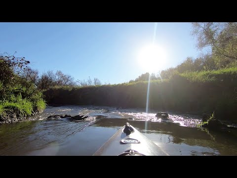
Photo Gallery:


No Comments