
Deerskin Road/Forest Road 2199 to Rangeline Road:
The Deerskin River is a wild and mostly undeveloped little gem that gently meanders through classic northern Wisconsin landscape over crystal clear water, a sandy bottom and around occasional glacial erratic boulders. It’s a short but varied trip that changes complexion from open to forested to marsh, and back to forested surroundings. With easy accesses and an obstruction-free run from start to finish, it’s well worth the day trip if you’re in the Eagle River area. Quite frankly, this was a surprising little find that exceeded any of my expectations.


Rating: ☆ ☆ ☆ ☆
Trip Report Date: August 17, 2021
Skill Level: Beginner
Class Difficulty: Flatwater
Gradient:
≈ 6′ per mile
Gauge Recorded on this Trip:
Anvil Lake (Eagle River): ht/ft: 95.27 | cfs: 1696.26
Gauge note: This is a correlative gauge which may not actually be helpful in the least since it measures lake levels but hey, I recorded it anyway.
Visual Gauge:
Deerskin River Visual Gauge
Located at the takeout on Rangeline Road.
Recommended Levels:
These were great levels but I have no idea if the correlative gauge above is any indication of water levels since it’s lake data. The Deerskin is said to have steady levels throughout the year. I’ve provided a visual gauge which is sitting feet in front of you at the takeout. If it looks like that, you’re good to go.
Put-In:
Dirt road access off Deerskin Road/Forest Road 2199, Chequamegon-Nicolet National Forest
GPS: 45.98363, -89.13153
Take-Out:
Rangeline Road, Eagle River, Wisconsin
GPS: 45.95171, -89.1764
Time: Put in at 9:45a. Out at 12:00p.
Total Time: 2h 15m
Miles Paddled: 5.25
Wildlife: Blue winged teals, trout, sandhill cranes, a wood duck and some undentified critter.
Shuttle Information:
The shuttle is a short six minutes by car. To find the put-in, take Deerskin Road all the way into the edge of the Nicolet National Forest (FR 2199). Just a few hundred yards after the road turns to gravel take the first unmarked dirt road on the right. It’s a little rutty at first, but most vehicles should be OK. There’s a clearing before the access point for additional parking. The put-in is clearly defined with a trout limit sign marking entry. This is also completely doable by bike and almost entirely paved. It’s a bit hilly, but manageable… …and watch fer deer.

Background:
How does the operator of Miles Paddled spend a family reunion with seventy people? He looks to escape and paddle the Deerskin River, of course. (Ha ha. I kid, my wife’s entire family is awesome.) But a family reunion is what brought us up to Eagle River and with seven days ahead of us, I figured I just might find some time for a diversion from the resort. Actually, I’d planned on making time because my wife’s cousin John is an avid paddler and we’d been talking about getting out together for some time now. I was happy to see he had two canoes strapped to the top of his truck when he arrived, one being the sweet Bell Wildfire I picked up for him at the Rutabaga boat swap just last year.
I wanted to explore something nearby for a day excursion. I knew that the near-headwaters of the Wisconsin River was popular but I was looking for something more obscure, of course. I discounted Eagle River itself as an idea because any lengths of it between lakes were too short and congested with power boats, pontoons, jet skis, etc., but I assumed that there had to be something more interesting considering the number of lakes in the area.
So while looking over some maps and my GPS, I came across Deerskin River which rung a bell. I had remembered hearing the name (it is rather unique) and then found it in Rick Kark’s guide. The information he provides is admittedly outdated but I put it on my to-scout list. Upon looking into it further, it seemed like there was a legit take-out off Rangeline Road, the question now became, where’s the ideal put-in? I found a link from years past that suggested the Northwoods Land Trust might be able to help me locate the proper put-in upstream so I reached out and not only did they respond but they even provided specific coordinates. Coincidentally, the take-out happened to be a mere six minutes up the road from where we were staying and the put-in, just twelve. It was a sign.
As soon as I got to Eagle River, I scouted both access points but was a little nervous that A) there may not be enough water, and more importantly B) there might be too much deadfall as the put-in was in a heavily-wooded piece of the Nicolet National Forest and the creek looked very narrow. I had learned weeks prior that Eagle River suffered widespread damage from a massive storm that swept the area and there was still evidence everywhere of debris, downed trees, damaged buildings and signs within the city itself. Surely, this narrow creek was going to be choked with deadfall creating a portage-fest based on everything I saw. Turns out, never judge a river by its access points since they were completely wrong assessments.
After scouting I stopped by the local outfitters, Wildwood Outdoor Adventures, and spoke with some friendly folks who gave me some good intel. I was told by one of the guys that the water was up and everything was on the menu. I asked about the storms and he said all he’s been doing is clearing and unless something new fell, all should be good. They service the nearby semi-headwaters area of the Wisconsin River but he recommended some of the mysteriously theme-named trips (like “Wildlife Paddle”, “Northwoods Bucketlist Paddle”, etc). I had a hunch that one of their paddles might be Deerskin. I’m not entirely sure they service this section, but I surmise one of those two is this trip on the Deerskin as there was some evidence that it had been maintained with a few fresh saw cuts. And even if it’s not, I’m sure they’d be willing to offer shuttle service if you inquired.
While running for some fishing bait, I scouted the takeout a second time a day prior to our trip and had a random encounter with two kayakers taking-out. They confirmed that it was free and clear and that it took them 3.5 hours but admitted they just floated the entire way. So, feeling confident as one can about water levels and deadfall, John and I set out early on the Deerskin River the next morning.
Overview:
The Deerskin River begins near the Michigan Border but these are the last few of the paddleable miles before it reaches Scattering Rice Lake, one of the Eagle River chain of lakes which eventually flows into the Wisconsin River. It’s a prized trout stream, biologically diverse and wildly varied. This specific stretch changes complexion numerous times, adding to its appeal. From briefly narrow to wide open to light-marsh to forested to wide again and then heavy marsh back to wooded and boulder-studded river bottom, it makes for an interesting and enjoyable paddle.
The put-in is off the beaten path, quite literally. There’s a short semi-rutted dirt road that leads to the access point and a clearing with parking for a few vehicles. The landing itself is steepish, but not very challenging. While the river appears narrow right at that put-in, it gives way to open space as soon as you clear the landing.
The first thing you’ll notice is the amazing water clarity. This will change by the time you get to the takeout but for the most part, the water is crystal clear and the river bed’s sandy bottom undulates like underwater sand dunes. It can go from a foot shallow to 6′ feet deep in the stroke of a paddle. Soft shallow grasses flank both banks with medium-sized brush, flowers and the occasional patch of cattails. It feels very open and the trees are kept in the distance for now.
The river twists and turns for quite awhile until suddenly, the environs change and the surroundings become more forested with tall pines and a few boulders appear, dotting the riverbed. The forested environment becomes thicker making for some interesting reflections on the water, as well as adding a dimension from the layers and layers of cedars, spruce and white pines flanking the banks.
This felt like a very rugged section in contrast to the clean, open feeling of the gentle marsh grasses, but with a pristinely-forested up north kind of feel. Branches and tree limbs bend and arch over the water, while others stand straight and perfect as arrows.
Some branches stick up and out of the bank, some from the riverbed directly at and in front of you, requiring some basic maneuvering skills under the occasional limb (which by the way, any of these could become an obstacle the next time a storm rolls through). Occasionally, the weeds and grasses listing gently on the surface swaying downstream were abundant but not a disruption to bog down any sort of momentum. You’ll encounter some areas with a handful of boulders that could constitute a boulder garden but what was really surprising was the size of some impressively large random ones that sporadically appear, chiseled into interesting shapes by water and time. I really had no expectation there would be such variety through half the paddle.
This continues for quite some time until the environment once again becomes open, much like the start of the paddle. The makeup gets a bit more varied with a few small grassy islands that split the middle creating channels where most often you could safely assume either one were deep enough to take. John and I often wove through different paths but could barely continue the conversation over the tall grasses.
Soon it becomes very marsh-like, almost instantly. Lilypads become more common along the edges, the water turns from crystal clear to opaque brown, and the floor transitions to more mud versus sand. While the river is generally only as wide as 20′, it opens up to its widest at 75′ in this marsh section. As a sidenote, the Google Map view isn’t all that accurate when it comes to the width on this river. The marsh is much narrower than it appears from the satellite view. Either way, it’s never terribly uncomfortable to paddle side-by-side but easier to navigate some tight turns in the narrows as a train.
At the end of the marsh is a new sign indicating the edge of the Dan Wisniewski Deerskin River Nature Preserve, dedicated as recently as 2020. The sign notes the takeout location to hike/tread lightly back into the 40-acre reserve which holds an abundance of old growth white cedars which are “remnants of what these swamp forest habitats looked like before the logging days”.
Just past the Nature Preserve is a DNR location where recent monitoring of the invasive species purple loosestrife is taking place. We only knew that’s what it was because there was a sign attached to one of the many new poles indicating so. This was quite a coincidence because weeks later I would help create a feature on Aquatic Invasive Species with Jeanne Scherer who is an AIS specialist for the UW Madison Extension Natural Resources Institute, and her specialty species as the statewide biocontrol coordinator is purple loosestrife. Coincidence, indeed.
A short clip later, there’s a rather noticeable change once last time to a forested and narrow section. Here, development is most obvious with many cabins on both banks set back and up from the river. It’s a short leg but it’s pretty with boulders almost the entire way to the takeout. The takeout is river-left before the Rangeline Road bridge and it’s a much easier than the put-in. Parking is shoulder-of-the-road parking with enough room for a few cars. Out of curiousity we paddled past the Rangeline bridge where just beyond are a few more sizeable boulders but the current soon slackens as it enters Scattering Rice Lake.
What we liked:
Everything about this trip. Specifically, the fact that it far exceeded my expectations. To be honest, I wasn’t very optimistic this would be paddleable or even that interesting even it were. I couldn’t have been more wrong. With easy access, solid water levels, no obstructions and a shocking amount of environmental diversity, I couldn’t have asked for more.
Above all else, paddling with John for the first time was the highlight. He knows we at Miles Paddled can (and do) get ourselves into some situations and I didn’t necessarily giving him a confident “hey, this is going to be a great paddle” prior to this trip. But I sensed he could roll with the punches, come what may. He’s well-seasoned (most likely, more than me) as he’s been guiding trips in the Boundary Waters for some time and he’s passionate about paddling. It was awesome to get out on the water with him after talking about it for so long. Best yet, it turned out to be a pretty solid trip.
What we didn’t like:
Not a thing. This was a great paddle and highly recommended. We saw very little wildlife on the river but it was late morning and I was rather chatty. There were deer everywhere on the roads around Eagle river, however. They’re the northwoods equivalent of squirrel in sheer numbers, often just grazing on the side of the road.
If we did this trip again:
Rick Kark has explored upstream sections of Deerskin, as well as the nearby Blackjack Creek. I understand the appeal and see why he wanted to continue exploring further and further upstream until it became too bogged down with deadfall -but that is what you’d likely encounter if you too, were curious. Instead, we’d reco and redo this section which is clean, easy and pretty, with no deadfall despite recent storms but of course, only with a little help from some friends.
Midway through our paddle John was curious what I’d rate this since I said everything starts at a three to begin with. I immediately said three but as I was explaining all the reasoning, the river kept unfolding with more and more personality, and soon it became a four. But it did beg the question, why not a five? Well, I have a very specific piece of criteria on what makes a five. Maybe I’ll share that someday.
Finally, I don’t think I’ve ever suggested this before, but I think this section of the Deerskin would make for an awesome evening paddle. With its wonderfully wide views and northwoods surroundings, I’m willing to bet it would make for a real pretty sunset cruise. Maybe that’s what we’ll do at the next reunion.
***************
Related Information:
General: Deerskin River Nature Preserve
Good People: Northwoods Land Trust
Outfitter: Wildwood Outdoor Adventures
Miles Paddled Video:
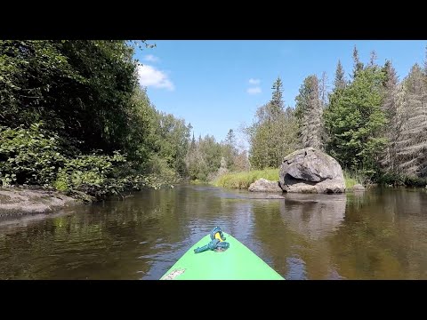
Photo Gallery:


2 Comments
Thalweg
September 6, 2021 at 9:23 amIf you want a slightly longer paddle on the Deerskin, there is a good put-in just over a mile upstream of your suggested put-in. To get there, rather than turning on the first unmarked dirt road after FR 2199 turns to gravel, continue an additional .5 miles to FR 2199B. Turn right on FR 2199B and follow it until it dead ends at the river (about .5 miles). FR 2199B can appear sketchy, but it’s passable all the way to the river. Put-in coordinates are N45.98799, W89.12135. There is a small parking area there (large enough to park 3-4 cars). The landing itself is as flat as flat can be, in fact there is a small pier at water level, so launching couldn’t be easier.
It’s just over 1 mile of paddling from the landing at the end of FR 2199B to where you put in. I encountered 1 downed tree (easily portaged) in this stretch when I did it in late May 2021, but other than that it was a very pleasant paddle.
If you want to make a day of it, from the end of FR 2199B you can paddle upstream on the Deerskin to the mouth of Blackjack Creek and then upstream on Blackjack Creek to Blackjack Springs. It’s 2.75 miles from the end of FR 2199B to Blackjack Springs. You have to paddle against a moderate current for the first 5 minutes while you’re on the Deerskin, but the current on Blackjack Creek is imperceptible (although you may have to drag over 1 or 2 low beaver dams). This area is in a federally designated wilderness area and the springs itself are in a state natural area. The scenery is excellent. Part way up Blackjack Creek, there is a hill on your right (river left) that you can climb to get a commanding overlook of the area.
The side trip up Blackjack Creek to the springs is well worth it. You can do this as a 5.5 mile no-shuttle round trip from/to the end of FR 2199B or you can make a day of it by continuing on downstream on the Deerskin to Range Line Rd (as you described).
One other note on the Deerskin, you mentioned that Google Maps isn’t very accurate regarding the width of the river on part of the Deerskin. That’s because there used to be a dam and flowage on the Deerskin. The dam was removed in 2001 and the river has since reverted to its original channel. However, Google Maps (and most other maps for that matter) still show the flowage even though it hasn’t existed for 20 years now.
Barry Kalpinski
September 6, 2021 at 11:35 amThanks for the great info – especially the dam removal. I never came across that info but it does explain the satellite image. I also didn’t mention that on that first road, there was a another put-in way at the end of it but it was rather brushy and not as clean as the first one. I did scout the next road into the forest but it kind of ended at a turnaround and it was still a ways away from the creek to haul a boat. Sounds like there’s another road I need to scout next time. Appreciate the info!