Valley Road to Paoli:
An otherwise pleasant river, this is not a segment of the Sugar I’d recommend. There are just too many wires to slip through, deadfall to negotiate, concrete footbridges to portage, etc.
 Rating: ☆
Trip Report Date: July 22, 2011
Skill Level: Beginner
Class Difficulty: Class I
Gradient:
3.5′ per mile
Gauge Recorded on this Trip:
Verona: ht/ft: n/a | cfs: 54
Brodhead: ht/ft: n/a | cfs: 380
Current Levels:
Verona: ht/ft: 3.26 | cfs: 66.2
Brodhead: ht/ft: 1.86 | cfs: 545
Recommended Levels:
We recommended this level. Please note that anything below 50 cfs will be extremely shallow and frustrating. We recommend a minimum of 60 cfs on the Verona gauge.
Put-In:
Valley Road, Verona, Wisconsin
GPS: 42.97305, -89.56618
Take-Out:
County PB Bridge, Paoli, Wisconsin
GPS: 42.92949, -89.5244
Time: Put in at 5:30p. Out at 8:00p.
Total Time: 2h 30m
Miles Paddled: 6.75
Alternate Trip Ideas:
Riverside Road to Paoli (5 Miles)
Wildlife:
Some herons, two mergansers and great big flopping carp.
Shuttle Information:
5.5 miles.
Background:
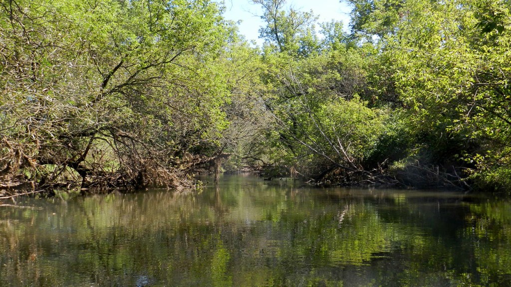
Taking my cue from Capitol Water Trails, I was inspired to explore a couple stretches of the Sugar River not mentioned in the more official paddling books. Well, it turns out there’s a reason why they’re not mentioned, they’re hardly paddleable. I was initially excited to “escape” so close to home, however, I didn’t find its proximity consolable in the least after a number of annoying obstructions (one right after the other). The Sugar here, is narrow and windy and is not altogether unattractive but neither is it so great as to warrant putting up with its frustrations (at least in my opinion).
What we liked:
There are a couple of steep hillsides (which I always like) and there are a few more sweeping vistas of the surrounding landscape (which I like as well). Towards the very end is a one-foot drop that is splashy and fun to go down and/or surf against. There’s usually enough water to run this virtually year round and yes, it is quite close to home (if you live in Madison). Lastly, odds of spotting a heron or two are pretty good as well.
What we didn’t like:
Take your pick: the barbed wires, the deadfall, the concrete footbridges, the mud… it’s just not worth it. None of those obstructions individually or in aggregate dissuade me much, so long as the river itself is worth it (or the surroundings). Neither is the case for this section of the Sugar. I found it much more frustrating than fun.
If we did this trip again:
Very doubtful, unless all the crap is cleared out.
Trip Update:
I ended up doing a shorter clip of this trip on 3/10/13. Perhaps infused with renewed paddle inspiration after Canoecopia, and needing to get out of the house at the time, I went out for a jaunt. Bad idea – very bad, dumb idea!
First off, it was raining/sleeting and about 35 degrees. Second, it had been raining all weekend with warmer temperatures a couple days preceding that, which meant the snow was melting very quickly. Thus the Sugar, which is otherwise painfully plain and pretty slow, was raging. This actually attracted me to it, but it was a poor judgment call on my part. Take it from me, when you see whole logs flow down the river, it ain’t safe!
There was a lot of water this day and it was moving very quickly. All of the obstructions were still there and profoundly more dangerous in high water conditions. I got pinned against one fallen tree and then before I had a second to figure out what to do or how to do it I got dragged by the current underneath the tree and took a rather undesirable swim. I was dressed for such an incident but still the whole thing pretty well spooked me out. A lesson was learned, albeit the hard or at least humiliating way.
***************
Related Information:
Sugar River Overview: Sugar River Paddle Guide
Sugar River II: Paoli to Belleville
Sugar River VIII: White Crossing Road to Valley Road
Good People: Upper Sugar River Watershed Association
Good People: Lower Sugar River Watershed Association
Map: Upper Sugar River Trail
Outfitter: Sugar River Outfitters
Wikipedia: Sugar River
Miles Paddled/Driftless Kayaker Video:
Alternate Trip Report: Shorter Paddle (5 Miles)
Riverside Road to Paoli
September 14, 2014
☆ ☆ ☆
A charming and short stretch quietly nestled in the soft hills and farms of southwestern Dane County, featuring clear water, riffles, pretty stands of majestic oaks, good wildlife, a fun rapid and the button-cute hamlet of Paoli. This section has been greatly improved upon and receives our paddling endorsement.
Gauge Recorded on this Trip:
Verona: ht/ft: 3.27 | cfs: 53
Brodhead: ht/ft: 1.84 | cfs: 496
Current Levels:
Verona: ht/ft: 3.26 | cfs: 66.2
Brodhead: ht/ft: 1.86 | cfs: 545
Put-In:
Riverside Road, Verona, Wisconsin
GPS: 42.95855, -89.55882
Take-Out:
County Road PB Bridge, Paoli, Wisconsin
GPS: 42.92949, -89.52439
Time: Put in at 1:10p. Out at 2:45p.
Total Time: 1h 35m
Miles Paddled: 5
Wildlife:
Blue-winged teal, great blue heron, green heron, deer, killdeer, kingfishers and unidentified fish.
Background:
If ever there were a stream that embodied the old adage “you never paddle the same river twice,” it’s the Sugar – this section in particular. They say you never paddle the same river twice because each experience is unique and has its own feel and conditions (favorable or fubar) change all the time. This was my third time paddling the Verona-to-Paoli leg of the upper Sugar and it was by far the best occasion. Some of that has to do with my own growing up as a paddler but much of it is thanks to the commendable work of both volunteers cleaning up the Sugar as well as Dane County purchasing tracts of now public land along the river.
Gone are the concrete footbridges midway through this short jaunt as well as the fallen tree against which I was pitifully pinned and rolled under last year (an almost lethal debacle that still spooks me when I replay the incident in my head, one whose eerie association with the term “deadfall” is uncomfortably close to home). Two strands of barbed wire remain but they’re fairly decrepit, easy to discern from afar and duck under. Plus they’re both located shortly after the put-in at Riverside Road, so they shouldn’t surprise you. In fact, there were no obstructions until the very end of the trip.
About midway into this paddle I happened upon two other kayakers lazing about in the sun and they told me that a friend of theirs had paddled this stretch recently and had informed them of a downed tree near the dam (where the 2’ drop is located) and another by the Range Trail bridge. That information was spot-on. Shortly after the 2’ drop is a downed tree but a narrow clearing on the far-left made it passable. Alas, about 25 yards downstream from the Range Trail bridge was a honking-big fallen tree from bank to bank, likely the victim of one of the several thunderstorms we had had back in early September. That one I had to climb over – the only such annoyance on this otherwise spectacularly improved trip. The good news is that the great folks at the Upper Sugar River Watershed Association (USRWA) know about it and plan on clearing it (which, by now, a month later, may well have happened already). So I think it’s entirely reasonable that this stretch should be obstruction-free if you choose to paddle it and it’s definitely worth checking out.
What we liked:
What begins as little more than a drainage ditch near the headquarters of Epic cuts its way through Dane and Green counties and then down into Winnebago County in Illinois, more or less marking the periphery of the Driftless Area. As such, the surrounding landscape is picturesque. Plus there’s something cool in knowing that this little stream that begins just west of Madison flows all the way down to Illinois where it teams up with the Pecatonica before joining the Rock – both of which begin in Wisconsin – on its way to the mighty Mississippi.
One of the nicest parts of this little trip is how much variety there is in only five miles. True, most of the paddling is through pastures but there are a couple steep hillsides, a glimpse here and there of the gently rolling landscape at the fringe of where the last glaciers came and ended and the Driftless begins. Especially nice are the many old oaks, handsomely macabre in their gnarled isolation. The river does meander but it has moments of straightaways too, sometimes tree-canopied, other times in savanna settings of unbroken sunshine. Predominantly rural/agricultural, this trip finishes in the cute-as-a-button tiny town of Paoli, today a hub for road bicycling enthusiasts and also an artist community.
The water is clear, the bottom sandy and the current generally reliable. But for one very wide section about midway, the river is generally 30-40’ wide. There are obstacles to dodge but usually none so formidable as to be dangerous (again, usually). One of the darling highlights near the end is a 2’ drop where there used to be a dam. Predictably, you’ll hear the sound of the rushing water well before you come upon it. Also, there’s a sign that reads “Dam, Swift Water” alerting you beforehand. A well-marked portage trail allows you to circumvent the drop – or allows you to run it, get out and run it again as many times as your heart desires. It’s a sweet little drop that is a perfect combination of not really dangerous but just adrenaline-raising enough. Surfing below the drop is a whole lot of fun, too.
Riffles will take you along 100-200 yards of pretty backdrops of woods and steep banks to the charming take-out behind the beautifully restored old mill building. There’s no designated launch but the lawn is only half a foot higher than the water, so taking out is pretty easy. A short walk across the lawn leads to the gravel parking area on Canal Street.
What we didn’t like:
This is the upper Sugar River, so adequate water levels can be an issue. At 3.27’ and 53 cvs, (the levels at which I paddled this trip on this day) there was just enough water to manage the shallow sections. Still though, I’d recommend paddling this with more volume. Another 2-3” would have been perfect, especially for the fun riffles leading into Paoli.
The barbed wire also is unfortunate, of course. It’s pretty easy to discern and negotiate, as I mentioned above but still, who wouldn’t prefer that it never be strung across public rivers in the first place?
Last, the put-in at Riverside Road is totally fine and adequate but it’s somewhat confusing in that from first appearances it doesn’t look all too inviting or accessible. There is no signage for one and the path leading from the road to the river is more a trampled one made by footsteps, not one that was mowed. The bank is steep and the parking is along the road. You just have to trust me on this: the actual public access is on the upstream side of the bridge on the river-right. What’s strange is on the downstream side, river-right, there is a sign facing the river – meaning that it’s legible only if you’re already on the river – stating that this side is private property and that public access is on the other side of the bridge. Presumably this is for paddlers who have put-in upstream (about which consideration I’ll mention something in a moment) but why not have at least a modest, unadorned sign (hell, a flier) on dry land telling you where you may and may not go?
OK, so why not put-in further upstream? It’s a good question, particularly since there are two acknowledged public-access landings on USRWA’s own map of the upper Sugar. One on Bobcat Lane (north of Highway 18/151) and the other on Valley Road (south of Highway 18/151). I’ve never even scouted Bobcat Lane but it seems safe to speculate that one would need a whole lot of recent rain or snowmelt to put-in there without getting stuck in shallows. The map indicates a “rapids” between Bobcat and Valley roads, which sounds intriguing. As for Valley Road, I do not now recommend it. As of 2013 there still were barbed wires and a questionably legal cattle gate on the segment of the river between Valley and Riverside.
Incidentally, Bobcat to Valley is 2.3 miles and Valley to Riverside is 1.8 miles, so tacking both on would make for a 9.1-mile trip to Paoli. But until we learn that the Valley to Riverside section is relatively clean (at least from the cattle gate, for God’s sake!) then we recommend only the Riverside to Paoli section. Also, there is a very dangerous cattle gate that is indisputably illegal – flagrantly and egregiously illegal – just downstream from Paoli. USRWA and Capitol Water Trails both know about it. Even the DNR knows about it. The property owner has been asked to remove it and by asked I mean offered to have it replaced by something more paddler-friendly by the very groups themselves at no extra cost to the property owner and yet still the monstrosity is in place!?! Until it is dismantled, we strongly discourage the Paoli to Belleville section.
If we did this trip again:
Well, this is my third time paddling this trip. Due to its proximity to Madison and its potential for a short morning or after-work paddle, it’s always fun. Next time I will wait for a little more water on the river to enjoy the riffles better. At some point I will embark on the upstream options, because I’m a stubborn and curious guy.
Photo Gallery:


6 Comments
Andy Richardson
September 14, 2013 at 1:56 amI went through this section (before finding this awesome website) on July 20, 2013. I agree, probably not worth doing again. Besides the dead falls and the low cement crossings, there was also a cattle gate somewhere near the first red mark on the map above. I could not manage to get under the gate in my kayak (are we supposed to be able to do that?). This gate had a very narrow water passage on the right hand side, yet that narrow passage was lined with barbed wire on the river side. I thought I would certainly end up needing to grab or otherwise scrape off a few layers of skin trying to go down that alley which appeared to be about as wide as my kayak. So I managed to get out in what was a mud bottom. More like quick sand. Almost lost both sandals in the muck. Eventually went barefoot. I was able to walk my boat under the gate, through the muck, to the other side. And move on to the next obstacle.If you're going to do this route, bring some decent work gloves with you. It will make dealing with the wires (some are barbed, some are not, some are hard to spot depending on the level of the sun) much easier.Putting in a Riverside Road will cut out the cattle gate above.
Miles Paddled
August 29, 2016 at 7:52 amHey Andy,
Thanks for comments and your kind words!
A lot has changed on this little trip just in the last three years. For one, the low-clearance cement crossings have all been removed, thanks to the Dane County Parks acquisition of lands along the river near the Bruce Tree Company farm.
As for the cattle gate, that ugly monstrosity is still there, alas. It’s for that reason that we recommend beginning at Riverside Road, one bridge downstream from Valley Road. To be clear, if a gate does not swing forward (downstream), allowing for safe passage, then it is in violation of the law. While this is the case, it’s a rarely/barely enforced law. And we get it: the farm, farmer, and maybe even the cattle have been there before recreational paddling became as popular as it has. As paddlers, we see all navigable waterways as prospects for our canoes and kayaks. But we understand that it takes awhile for the way things always were to catch up with current events and trends. At some point this cattle gate will have to be in compliance, but until such time we should put in at Riverside Road. Thanks again Andy!
Richard H
August 28, 2016 at 4:37 pmThe wife and I did this trip today. Shakedown for our new Kayaks. We paddled upstream for a bit and was stopped by the cattle gate that is still there.
Nice flow at 65 cfm but a few trees made it a little cautious and one tree is completely blocking the route and needs to be portaged round.
Thanks guys for all the work you do.
Miles Paddled
August 29, 2016 at 7:53 amHey Richard,
Thanks for chiming in. It sounds like you started at Riverside Road, not Valley Road, which we strongly recommend since the nasty cattle gate remains intact. The Verona to Belleville section of the Upper Sugar is very narrow and tree-lined, making it quite prone to deadfall. It’s a classic example of how conditions on a single stream or section of stream can change after one storm or windy day. Do you recall approximately where the downed tree is located? The good folks at the Upper Sugar River Watershed Association do an outstanding job of clearing out blockages. We’d be happy to report this to them. Thanks again!
Richard Hollingworth
September 11, 2016 at 5:49 pmMP
Yes, we started on Riverside but paddled upstream until we got to the cattle gate. The tree obstruction is just after you go under the 69 I believe. I should have marked it on my GPS, lesson learned.
Miles Paddled
September 11, 2016 at 8:28 pmThanks Richard, we (and I’m sure other readers) appreciate the info!