Lee Road to Veterans Memorial Park:
A breathtaking trip visually, surrounded by a picturesque glaciated valley of rugged rolling hills, virtually all of which is public land, the aptly named Spring Creek here in the gorgeous Lodi Marsh is fed by innumerable springs, many pouring right out of the ground. The only problems are the million (more or less) deadfall obstructions and low water levels.
Rating: ☆ ☆ ☆
Trip Report Date: March 4, 2018
Skill Level: Beginner
Class Difficulty: Flatwater
Gradient:
~1′ per mile
Gauge:
Spring Creek: ht/ft: 3.8 | cfs: n/a
Recommended Levels:
This is the recommended minimum level. But even this is very low and quite impractical.
Put-In:
Lee Road
GPS: 43.27394, -89.56698
Take-Out:
Veterans Memorial Park, off Water Street, Lodi, Wisconsin
GPS: 43.31056, -89.52661
Time: Put in at 1:40p. Out at 6:00p.
Total Time: 4h 20m
Miles Paddled: 7
Wildlife:
Sandhill cranes, tundra swans, great blue herons, geese, wood ducks, mergansers, hawks, killdeer, kingfishers, red-wing blackbirds (notable given that this was March 4th), muskrats, beaver and deer.
Shuttle Information:
4 miles. Not the best bicycling shuttle, as Riddle Road is pretty heavily trafficked for a country road, but it’s plenty doable.
Background:
Before I got into paddling I hiked a lot (back in that twilight era before I swapped my boots for boats). One of my favorite places was the Lodi Marsh state natural area segment of the Ice Age Trail. It still is to this day. Together with Gibraltar Rock just northwest of Lodi, and the reticulated network of trails at Devil’s Lake State Park just across the Wisconsin River via the Merrimac Ferry, the Lodi-Baraboo hills area constitutes some of the best hiking in southern Wisconsin. For geology geeks, it’s a rich area featuring quintessential U-shaped glaciated valleys, a genuinely staggering topography for this part of the state. But it’s also where the bulwark of Baraboo Range quartzite impeded the last glaciers – basically, ancient mountain chain vs. colossal blocks of ice – leaving the area a unique mix of glaciated and unglaciated.
There are two trails comprising the Lodi Marsh segment of the Ice Age Trail, west and east. The west trail is a rare loop, so you begin and end at the same place, along a knob hill and prairie with direct access to a spring that literally flows out of the rock like a bubbler. The east trail is a more traditional point-to-point, one-way hike from Riddle Road to Highway 113 through forested areas and steep hills. I’ve hiked both of these trails countless times in the almost 15 years I’ve lived in Madison; always inspiring, never disappointing. But ever since I’ve become a paddling fanatic, I’ve wanted to experience Lodi Marsh via the water. I mean, it’s not a marsh for nothing! This trip has been on the backburner for a long time, and for some reason or another the first weekend in March was billed to be the day to do it.
Overview:
There is no official place to put-in, but there is a designated parking area off Lee Road, at an elaborate natural springs percolating right out of the earth, coming from who knows where. For all intents and purposes, this is the beginning of Spring Creek. It’s really shallow here – this is essentially the source of Spring Creek. If ever the expression “the sum is greater than its individual parts” applied to a stream, it’s Spring Creek at Lodi Marsh. There are springs coming from all directions, it’s quite unique. As a result, water volume will increase as you progress downstream… but it’s slow-going. You’ll probably need to schlep your boat 30 yards or so from the parking area until it’s deep enough with scraping the bottom (although the bottom is all sand and silt).
Things are nice and clear in the very beginning, even if the creek is shallow. Then you slip into some woods, and everything gets hairy and harried real quick. Strainers, vines, submerged logs, fallen trees – it’s pretty much a s#!t show for ¾ of a mile. Some of the obstructions are certainly negotiable if you’re flexible and agile (and in a boat no longer than 11′). But you’ll invariably need to portage a time or two (or seven or eight).
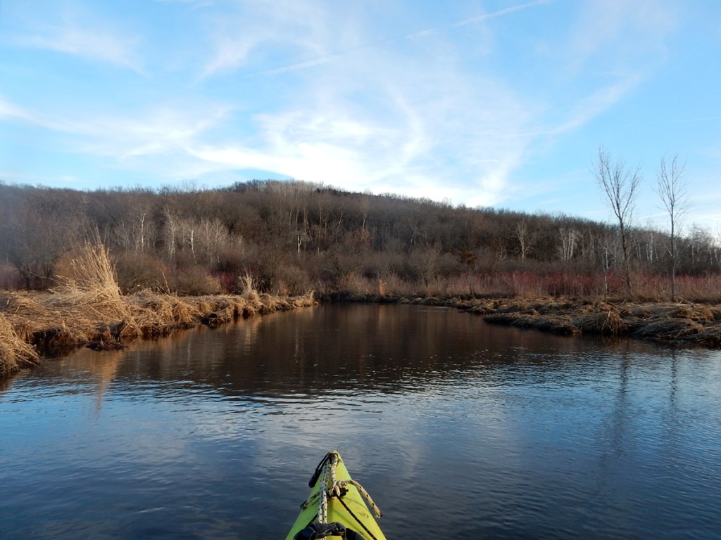
Eventually, the trees disappear, the landscape opens up, and you’re basically in the marsh proper. Hello cattails! Hello birds of different feathers, especially during migration time. The only time we saw wildlife was in the marsh proper (maybe because we were too loud or distracted with the deadfall elsewhere), but it was outstanding. For the next 5-ish miles everything is clear and unobstructed. There are valley views galore – some providing the steepest backdrop you’re likely to find on a stream in southern Wisconsin. And there are no fewer than three outstanding natural springs feeding the mainstream, all on the right. Two of the three will be too shallow to paddle up, and even one – which is the most dramatic of any of the springs in Lodi Marsh – will be a little sluggish. We strongly recommend just getting out and walking along the banks to the springs’ sources, especially the most prominent of the three. The water coming out of the rock looks like a bubbler.
As you head into the heart of the marsh, the creek will just go bananas meandering this way then that, zigging here, zagging there. For those of us fond of straight lines being the most efficient distance between two points, the course of Spring Creek will just mug you in a dark alley. The weary paddler will be forgiven if she just wants to get out and walk a shortcut. There’s a set of power lines, where one could do this, by and by.
Suddenly, you’ll come upon a totally random but well-built pedestrian bridge. Presumably it’s for a farm… or perhaps a snowmobile trail. It’s admirably constructed, either way. After this, both banks will be tree-lined again with some obstructions to dodge; we didn’t have to portage anything, however. Indeed, we were downright shocked that this was open. We know we’re not the only folks who’ve paddled this, so thanks might be in order to those who’ve cleaned this up some, even if it’s just for fishing.
This brief stretch leads to the culvert bridge at Riddle Road. It’s not a great take-out option, but A) it’s doable and B) the next .7 mile is just awful, so it behooves you big-time to get out here while you can. Also, everything downstream from Riddle Road is totally developed and private land. First, you’ll pass a half-dozen back yards, where the first portage will be found. (From here to Veterans Memorial Park the creek does an encore performance of its deadfall number, but now with steep banks that don’t permit the easiest portaging.) Then a gorgeous railroad bridge/tunnel (aka “brunnel”) from 1888 comes into view. You need to take the left channel at a small island, as there’s strung barbed wire on the downstream right side. Why?!? The current is peppy in the brunnel, but the limestone blocks out of which it was built are supremely admirable and deserve attention.
Depending on your flexibility and stubbornness, you may need only to portage once or twice in the next couple hundred yards. More likely, 3-4 times. Besides the steep banks, the current picks up in this section (and will continue through town), making portaging extra tricky (and why you should have taken out at Riddle Road when you had the opportunity).
Finally, a straightaway appears where the creek trots directly parallel to Water Street and the road bridge connecting Water Street and Highway 113. The ad hoc take-out is on the downstream side of this bridge, on the left. It’s a pleasant riffly spot, but there’s no good place to exit here. All there is, is riprap and then an annoying retaining wall above it. Frankly, it’s a crappy place to take out, but it is at least public, and street parking is a few paces away. Otherwise, there’s no real access for another half-mile or so through downtown Lodi (where the creek is almost always too shallow to paddle – but really fun and uniquely scenic when it’s up).
What we liked:
While the put-in is a little dodgy in terms of paddling, it’s quite beautiful. It’s a rare thing to see such a striking sight as a natural spring just percolating out of the earth, and this one is quite dramatic. And the water color here, of course, is crystal clear with a cushy sand bottom. It’s lush. We even saw footprints from someone fishing as well as those of a sandhill crane. Wet fossils.
While you’re on the creek, there’s something really cool about seeing all these feeder natural springs come in from every which way. Once you’re out of the godforsaken wooded area in the first mile you’ll be paddling along a knob hill 150′ tall. There are three natural springs at the base of this hill, the third of which is one of the best examples I’ve ever seen. In springtime, this area gets carpeted with skunk cabbage. We were a few weeks too early for that.
In addition to the springs, the main reason I’ve wanted to paddle Lodi Marsh these many years is to take in all the hills and bluffs from the water’s perspective. This did not disappoint in the least! Indeed, there’s one hill due north of the marsh that provided probably the tallest backdrop I can think of in southern Wisconsin while paddling. The valley views and gurgling springs made this trip worth it. And the wildlife was pretty awesome.
What we didn’t like:
Loads of deadfall, low water.
Consider this: it took us two hours to paddle approximately one mile. That’s incomprehensibly horrible! But that’s A) how low the water was/is in the beginning and B) how many obstructions there are. We did do a fair amount of sawing and snipping – call it Spring cleaning, which of course added to our time. But there are still a half-dozen mandatory portages. The bulk of this junk is in the first mile, from Lee Road. After that, it took us only 90 minutes to paddle 5-ish miles, which is pretty good time on any stream, especially for one that meanders as bewilderingly as Spring Creek through the marsh.
And then it took us the better part of another hour to paddle the 2/3 of a mile from Riddle Road to Water Road, due to its many obstructions and frightening portages. That section just flat out sucks, to be frank. Not only is it entirely developed (a mix of residential back yards and commercial buildings), but we’d been lulled/led to feel a sense of confidence and optimism after the essentially unobstructed sections from the marsh proper to Riddle Road. Everything was on the up and up and looking good, until we ran into one cluster after another after another, etc. By this point, it was starting to get dark, and we were wet, cold, disappointed, and pretty much mentally done with this creek. Had it been more negotiable, I’m sure our attitude towards it would have been less critical. But as it is, it leaves little to be desired. The railroad “brunnel” is truly beautiful, but it comes at an expensive cost.
The put-in off Lee Road is really pretty aesthetically, but it makes for an impractical place to launch a boat – or even begin a trip. The creek was about a foot of water deep here and would stay that shallow for a good ¼ to ½ mile downstream. It was more using your paddle to push off the creek bottom than actual paddling. And butt-scooting.
The take-out at Veterans Memorial Park is pretty lousy as well, but for different reasons. First off, there really is nowhere to take out. The setting here is unusual. There’s a thin strip of irregular riprap on river-left in a riffly current. You have to just line up parallel to it and exit sideways… without letting go of your boat, which otherwise would be whisked away downstream. And then you have to hoist your boat up and over a 3′-tall retaining wall, which is a far cry from convenient, especially if your boat has water in it (which it almost certainly will after all the portaging and contentious deadfall) and weighs heavier than it ordinarily would. It’s a short schlep to the street here, where parking is a little ambiguous. We parked on the street, since it’s a public park right here and there are no signs prohibiting leaving a car there. Totally adequate, but it felt a little weird. And there’s nowhere to even pee discreetly at the park.
If we did this trip again:
Honestly, unless there is a dedicated effort to clean up the first mile with legions of chainsaws, then we really can’t recommend putting in at Lee Road (unless you don’t mind getting in and out of your boat many times). Better just to schlep your boat from one of the two parking areas off Riddle Road and accessing the water wherever you can. The current is next to nonexistent, so paddling upstream to take in the various springs and valley views would be easy – and a whole lot less frustrating and filthy than putting-in at Lee Road. Furthermore, the only case to make for paddling past the Riddle Road culvert bridge is going through the railroad “brunnel,” but it comes at a cost of difficult and moderately dangerous deadfall/portaging. Having experienced this already, if we ever paddle the marsh again, we’d just take out at the Riddle Road bridge.
Ultimately, however, this trip really is better for a pair of boots than boats. The views of the valley and the springs are just as sweeping and majestic from the Ice Age Trail as they are from the creek itself. It’s a rare day indeed when we’ll concede that, but paddling through the marsh is just a slog. We’re glad we finally did it, but it’s unlikely that we’ll be doing this again anytime soon.
Either way, dumb puns and all that aside, Happy Spring everybody!
***************
Related Information:
Spring Creek I: Fair Street to County Road V
Good People: Friends of Scenic Lodi Valley
Photo Gallery:


No Comments